Coeur d’Alene
Subbasin Summary
(including Coeur d’Alene Lake and all tributaries)
Prepared for the
Northwest Power Planning Council
March 16, 2001
Subbasin Team Leader
Coeur d’Alene Tribe
Contributors
| Idaho Department of Fish and Game |
USDA Forest Service |
| Idaho Department of Environmental Quality | USDA Natural Resources Conservation Service |
| Idaho Department of Lands | USDI Fish and Wildlife Service |
DRAFT: This document has not yet been reviewed or approved by the Northwest Power Planning Council.
Table of Contents
RELATIONSHIP OF THE SUBBASIN TO THE NWPPC FISH AND WILDLIFE PROGRAM
EXISTING PLANS, POLICIES AND GUIDELINES
GOALS, OBJECTIVES AND STRATEGIES
RESEARCH, MONITORING AND EVALUATION
FY 2002 Project Proposals Review
Appendix A: Wildlife species list for the Coeur d'Alene subbasin
Appendix B Coeur d'Alene Tribe Trout Production Facility HGMP (separate document)
List of Figures
Figure 1. Location of the Coeur d’Alene Subbasin within the Columbia River Basin Location in document
*Figure 2. Primary geographic areas within the Coeur d’Alene Subbasin Location in document
*Figure 3. Principle streams and waterbodies of the Coeur d’Alene Subbasin Location in document
*Figure 4. Land ownership within the Coeur d’Alene Subbasin Location in document
*Figure 5. Coeur d'Alene subbasin rain-on-snow sensitivity Location in document
*Figure 6. Historic versus present occurrence of westslope cutthroat trout in habitat patches on the Coeur d’Alene Reservation. Location in document
*Figure 7. U.S. Fish and Wildlife Service Wintering Bald Eagle Summary Location in document
*Figure 8. Vegetation coverage and principle streams in the St. Joe River geographic area of the Coeur d’Alene Subbasin Location in document
*Figure 9. Vegetation coverage and principle streams in the Coeur d’Alene River geographic area of the Coeur d’Alene Subbasin Location in document
*Figure 10. Vegetation coverage and principle streams in the Coeur d'Alene Lake geographic area of the Coeur d’Alene Subbasin Location in document
*Figure 11. Coeur d'Alene subbasin 1910 fire history Location in document
*Figure 12. Potential big game winter range in the Coeur d'Alene subbasin Location in document
*Figure 13. Water quality limited water bodies in the Coeur d’Alene subbasin Location in document
*Figure 14. Water pollution point sources within the Coeur d’Alene subbasin (NPDES and CERCLA sites) Location in document
*Figure 15. Road density within the Coeur d’Alene subbasin Location in document
*List of Tables
Table 1. Fish of the Coeur d’Alene Subbasin
Table 2. Historical and occupied range for westslope cutthroat trout (various sources)
Table 4. Wildlife species of concern potentially present in the Coeur d’Alene subbasin
Table 5. Breakdown of vegetative cover by key geographical area in the Coeur d'Alene subbasin
Table 6. Coeur d'Alene Subbasin Wetland Summary (As modified from Jankovsky-Jones 1999)
Table 7. Wildlife riparian habitat summary for Coeur d'Alene Indian Reservation
Table 8. Past accomplishments of BPA funded projects in the Coeur d’Alene subbasin
Table 9. Coeur d'Alene Subbasin Summary FY 2002 - 2004 BPA Project Proposal Matrix
COEUR D’ALENE SUBBASIN
Figure 1 Location of the Coeur d’Alene Subbasin within the Columbia River Basin
This document has been called for under the "Rolling Provincial Review Process" associated with the year 2000 amendment of the Columbia Basin Fish and Wildlife Program. It is intended to provide an interim framework for identifying and prioritizing fish and wildlife protection, mitigation, and enhancement activities while comprehensive subbasin assessments and subbasin plans are completed for each of the Region’s 53 subbasins.
Significant time and resource constraints as well as inconsistent agency and stakeholder participation has limited the ability of the core members of the subbasin team to conduct a process sufficient for creating a consensus based, comprehensive strategy for fish and wildlife mitigation actions in the basin that is inclusive of all agency and stakeholder support. This document is not intended to identify and resolve all resource management issues and differences, nor does it supercede the sovereignty and legal rights of the Coeur d'Alene Tribe or the legal rights and responsibilities of the State of Idaho in any way.
RELATIONSHIP OF THE SUBBASIN TO THE NWPPC FISH AND WILDLIFE PROGRAM
The Pacific Northwest Electric Power Planning and Conservation Act (Act) of 1980 explicitly gives the Bonneville Power Administration (BPA) the authority and responsibility "to protect, mitigate, and enhance fish and wildlife to the extent affected by the development and operation of any hydroelectric project of the Columbia River and its tributaries in a manner consistent with…the program adopted by the Northwest Power Planning Council (NPPC)…and the purposes of this Act." The Act further requires BPA and the federal hydropower project operators and regulators to take the program into account to the fullest extent practicable at each relevant stage of their decision-making processes.
The NPPC is a planning, policy-making, and reviewing body. It develops and monitors implementation of the Columbia River Basin Fish and Wildlife Program (Program), which is implemented by BPA, the U.S. Army Corps of Engineers (USACOE), the U.S. Bureau of Reclamation, and the Federal Energy Regulatory Commission (FERC) and its licensees. The Program is not intended to address all fish and wildlife problems in the Columbia Basin from all sources. Rather, the Program is meant to accommodate the needs of other programs in the basin that affect fish and wildlife, and unify and coordinate a framework for fish and wildlife mitigation and recovery activities across the basin.
Section 4(h) of the Act establishes statutory guidelines that the NPPC must adhere to in the development of the Program. The NPPC ensures that the Program complements the existing and future activities of the federal and region’s state fish and wildlife managers and appropriate Indian tribes and that they remain consistent with the legal rights of appropriate Indian tribes in the region (Section 4[h][6]). The NPPC also ensures this consistency by giving deference to the recommendations of the basin’s fish and wildlife managers in all decision-making processes and that they remain consistent with the legal rights of the appropriate Indian tribes. There are various statutory standards within the Act that the NPPC must adhere to, including:
Ultimately, the NPPC will amend into the Program specific subbasin plans that are consistent with the basin wide goals and objectives in the Program. The NPPC relies on subbasin summaries to provide the context for the development of subbasin plans. The subbasin assessment and planning process will complete the Program at the subbasin level and provide the implementation plans out of which fish and wildlife projects are proposed for BPA funding to implement the Program. These subbasin summaries are an interim arrangement pending development of the new Program. Subbasin summaries are a documentation of existing assessments, plans, and other information available within each subbasin and are written by subbasin teams.
ROLE OF THE FISH AND WILDLIFE MANGERS
Fish and wildlife managers comprise the core members of subbasin teams. Core members of the Coeur d'Alene subbasin team which have the legal responsibility for fish and wildlife management are the Idaho Department of Fish and Game (IDFG), Coeur d'Alene Tribe (CDAT), and the U.S. Fish and Wildlife Service (USFWS). These entities are responsible for coordinating fish and wildlife needs and management strategies; ensuring that subbasin summaries and plans have all of the elements necessary to protect, mitigate, and enhance fish and wildlife affected by the development, operation, and management of the FCRPS; and ensuring that the summaries are ready to submit to the NPPC. Other key members of the subbasin teams include 1) federal, state, and tribal land managers; 2) federal, state, and tribal water quality managers; and 3) private land owners and water rights holders. Their role in the subbasin team is to provide input on the status of habitat quality, ongoing monitoring efforts, and habitat strategies; recommend habitat actions to meet habitat quality objectives; and assure consistency with other planning efforts.
PROTECTION, MITIGATION, AND ENHANCEMENT RESPONSIBILITIES
The construction and operation of specific dams directly led to the complete and immediate extirpation of all anadromous and some resident fish populations as well as the permanent destruction of thousands of acres of critical fish and wildlife habitat throughout portions of the Upper Columbia River and its tributaries. Such is the case with Chief Joseph, Grand Coulee, and Albeni Falls Dams as well as additional hydrofacilities constructed along the Spokane River. The loss of biomass, hydrological alteration, and subsequent management of the landscape in ways not possible were it not for the existence of the dams, has severely altered the natural processes and ecosystem functions that defined and maintained the natural resources and tribes of these areas.
In its analysis of the contribution of the hydropower system to salmon and steelhead losses (see Council documents 87-15, 87-15A and 87-15B), the Council has addressed the extent to which resident fish substitutions should be used to mitigate losses of salmon and steelhead production in these areas.
The Council has concluded that: 1) compensation mitigation in blocked areas is appropriate where salmon and steelhead were eliminated by the development and operation of the hydroelectric projects; 2) to treat the Columbia River and its tributaries as a system, substitutions are reasonable for lost salmon and steelhead in areas where in-kind mitigation cannot occur; and 3) flexibility in approach is needed to develop a program that complements the activities of the fish and wildlife agencies and tribes and is based on the best available scientific knowledge.
Past mitigation within the subbasin has occurred primarily through implementation efforts by the Coeur d'Alene Tribe as off-site protection, mitigation, enhancement and compensation activities called for under Section 4(h) of the Pacific Northwest Electric Power Planning and Conservation Act and the Northwest Power Planning Council Fish and Wildlife Program. These activities provide partial mitigation for the extirpation of anadromous fish resources from usual and accustomed harvest areas and Reservation lands. Additional mitigation is also occurring to address impacts to resident fish and wildlife populations and habitats attributable to development of the Federal Columbia River Power System.
The Coeur d'Alene Subbasin lies in four northern Idaho counties: Shoshone, Kootenai, Benewah, and Latah. Coeur d'Alene Lake is the principle waterbody in the subbasin and serves as the base elevation for the principle streams and rivers in the area (Figure 2). The lake is the second largest in Idaho. Population centers are located on the northern most shoreline of Coeur d'Alene Lake (Coeur d'Alene) and at the mouth of the Coeur d'Alene River (Harrison). The city of Coeur d'Alene is the largest in Kootenai County and Harrison is the second largest in Benewah County. The largest town in Benewah County (St. Maries) lies about 19 kilometers (12 miles) upstream of Coeur d'Alene Lake on the St. Joe River.
The Spokane River, the only surface outlet of Coeur d’Alene Lake, flows westerly from the northern end of the lake to its confluence with the Columbia River, 160.9 kilometers (100 miles) to the southwest. A series of falls on the upper Spokane River formed barriers to the post-glacial dispersal of fishes, such as the Pacific salmon and steelhead trout, from the lower Columbia River to the Coeur d’Alene subbasin (Simpson and Wallace 1982).
The Coeur d’Alene subbasin is approximately 9946 square kilometers (3840 square miles) and extends from the outlet of Coeur d'Alene Lake upstream to the Bitterroot Divide along the Idaho-Montana border (Figure 1). Elevations range from 646 meters (2,120 feet) at the lake to over 2134 meters (7,000 feet) along the divide.
The lake lies in a naturally dammed river valley with the outflow currently controlled by Post Falls Dam. Post Falls Dam holds the lake level at higher elevations for part of the year than would occur under natural conditions and creates a backwater effect in the lower Coeur d’Alene, St. Joe and St. Maries rivers. At full pool (lake elevation 648.7 meters) the lake covers 12,900 hectares (31,876 acres) and at minimum pool level (lake elevation of 646.2 meters) the lake covers 12,200 hectares (30,146 acres). The lake is 42 kilometers (26 miles) long and anywhere from 1.6 to 9.6 kilometers (1 to 6 miles) wide. The lakes mean depth is 22 meters (72 feet) with a maximum depth of 63.7 meters (209 feet).
Many tributaries feed Coeur d'Alene Lake. The two principle tributaries are the Coeur d'Alene and St. Joe rivers that drain the Coeur d'Alene and St. Joe mountains, respectively (Figure 3). The St. Joe River basin drains an area of approximately 4,470 sq. kilometers (1,726 sq. miles) and contains more than 1,189 kilometers (739 miles) of streams with over 78 principle tributaries. The Coeur d’Alene River basin drains an area of approximately 3,858 sq. kilometers (1,489 sq. miles), and contains an estimated 1,052 kilometers (654 miles) of stream with over 78 tributaries. In addition, over 27 tributaries encompassing more than 321 kilometers (200+ miles) of streams feed directly into Coeur d’Alene Lake.
The climate and hydrology of the watersheds of the Coeur d'Alene subbasin are influenced by maritime air masses from the pacific coast and prevailing westerly winds, modified by continental air masses from Canada. Summers are mild and relatively dry, while fall, winter, and spring brings abundant moisture in the form of both rain and snow. Precipitation in the subbasin ranges from about 76 cm to over 254 cm (30-100 inches) per year. Cyclonic storms, consisting of a series of frontal systems moving west to east, produce long duration, low intensity precipitation during the fall, winter and spring. A seasonal snowpack generally covers the landscape at elevations above 1,372 meters (4,500 feet) from late November to May. Snowpack between elevations of 914 and 1,372 meters (3,000 and 4,500 feet) falls within the "rain-on-snow zone" and may accumulate and deplete several times during a given winter due to mild storms (US Forest Service 1998). The precipitation that often accompanies these mild storms can cause significant flooding because the soils are either saturated or frozen and the rain and melting snow is added directly to the runoff.
The runoff period and peak discharge from the lake generally occurs between April and June, but the highest peak flows recorded are from mid-winter rain-on-snow events. Peak flows from the St. Joe and Coeur d’Alene rivers have exceeded 1416 m3/s (50,000 cfs) and 1982 m3/s (70,000 cfs), respectively. Average monthly discharges from both the St. Joe and Coeur d’Alene rivers range from September lows of between 11 to 14 m3/s (400-500 cfs) to April-May highs of 198 to 227 m3/s (7,000 to 8,000 cfs).
Recently completed geographic assessments of the Coeur d’Alene and St. Joe river basins describe geologic and geomorphic processes affecting the Coeur d’Alene subbasin (US Forest Service 1998a, 1998b). Pre-Cambrian metasediments underlie most of the Coeur d’Alene subbasin. Faulting and subsequent mineralization in portions of this area have resulted in deposition of valuable minerals including sulfides of lead, zinc, silver and antimony and smaller quantities of copper, cobalt and gold. The lower reaches of the rivers and streams draining into Coeur d’Alene Lake have been eroded in Miocene basalts, which overlie the basement complex. The basalts, in turn, are overlain by glacial alluvium or windblown loess deposits of post-glacial origin (Ross and Savage, 1967). The southern portion of the St. Joe River basin and the St. Maries River basin have been modified or influenced by intrusions of the highly granitic Idaho Batholith. These intrusions have resulted in the formation of re-metamorhosed sedimentary rock that tends to be less stable than landforms based primarily on metasediments.
The relatively rapid rate of mountain-forming uplifting, along with the runoff associated with a moist climate, has resulted in larger streams and rivers adjusting by cutting deep canyons and valleys. Breaklands are a common land type in the St. Joe and Coeur d’Alene river geographic areas. Breaklands are typically steep and may be more susceptible to mass erosion in some areas.
Glaciation played a role in the landform development of the subbasin. Coeur d’Alene Lake has origins related to continental glaciation, and provides the base level for each of the geographic areas in the subbasin (Figure 2). The river valleys of the lower St. Joe and Coeur d’Alene rivers evolved into broad, widely meandering depositional river channels with extensive, frequently flooded zones and wetlands adjacent to the main channel. These areas are highly productive for aquatic species, and are very sensitive to actions occurring in upstream areas. Alpine glaciation in the upper reaches of the St. Joe and Coeur d’Alene rivers watersheds resulted in alluvial valleys which may be important for bull trout. The St. Maries watershed tends to be more rounded with less relief than most of the rest of the basin. Streams tend to be lower gradient, meandering streams, with a high percentage of the bed and banks, comprised of finer alluvial materials and deposits from ancient Lake Clarkia.
Land ownership in the subbasin is a checkerboard of private, federal, state and Tribal parcels (Figure 4). A portion the subbasin (approximately 760 square kilometers) lies within the boundaries of the Coeur d’Alene Indian Reservation and the entire subbasin lies within the Tribes’ aboriginal territory.
The watersheds of interest have evolved and adapted to a series of geologic and climatic events, including general regional uplift, volcanism, intrusion of granite materials, and several stages of glaciation and climate change. The historic range of conditions resulted in watersheds and biotic communities that have developed and evolved with an operating range and resiliency that allows them to adjust to both frequent and rare events. Recently, dramatically increased human populations have exerted stresses on the aquatic and terrestrial ecosystems. Anthropogenic changes, such as, urbanization, construction of Post Falls Dam, conversion of forests and wetlands to pasture and agricultural lands, road construction, and introduction of exotic species have disturbed many natural processes of the Coeur d'Alene subbasin and their biotic systems.
Forest management activities occur on National Forest, Bureau of Land Management, State of Idaho, Coeur d'Alene Indian Reservation, and private timberland. These activities include road building, harvesting, thinning, fertilizing and fire suppression.
Early logging in the Coeur d’Alene subbasin was largely centered on the river valley bottoms where logs could be easily skidded or transported by flume to the river and ultimately floated to downstream mills. Splash dams were used in the North and Little North Forks of the Coeur d’Alene River and tributaries to the St. Joe River, and in particular on Marble Creek. Railroad logging was common in portions of the Coeur d’Alene River and St. Maries watersheds. Prior to the establishment of the Idaho Forest Practices Act in 1990 and the National Forest Management Act, streams and riparian areas received little protection from harvesting, skidding and processing activities. The legacy of these activities still affects fish habitat in some areas of the basin and they must be addressed to protect and restore fish habitat.
Large openings in the forest canopy that permit free air movement over the snow pack can accelerate the rate of snow pack depletion. Openings from fires, insects and disease, and wind have always existed in the forested watersheds of the Coeur d’Alene subbasin, however, the relatively recent clearing of forestland for homesteads, logging, pasture, and agriculture have substantially enhanced this phenomenon. In Lake Creek for example, where nearly 40 percent of the basin area has been cleared for agriculture, peak discharges have increased by an estimated 55percent for 100-year events when compared with the pre-settlement period (CDA Tribe 1998). Forest clearing has occurred in the other Coeur d'Alene subbasin watersheds, and measurable increases in peak discharges for these areas have also been documented (IPNF 1994).
Agricultural activity is largely confined to the valley bottoms along the lower Coeur d’Alene, St. Joe, and St. Maries rivers, and on the Palouse region south and west of Coeur d’Alene Lake. Grazing allotments were established on some National Forest lands following the wildfires of 1910 and the 1930's. Large numbers of sheep were grazed until natural plant succession decreased forage, making grazing infeasible. Some cattle grazing allotments still exist in portions of the Coeur d’Alene and St. Maries rivers watersheds, and private ranches dot the valley bottoms. Current grazing of pack and saddle stock by outfitters and the Forest Service is short-term and site specific.
Agricultural activity has contributed to stream degradation in portions of the basin through increased sediment delivery, modifications to riparian areas, and the establishment of dikes and drainage districts which modify floodplains and may restrict spawner access to tributary streams. More recently, voluntary implementation of best management practices and participation in programs such as the Conservation Reserve Program (CRP) has helped to reduce agricultural impacts on water quality and streams.
Mining activities in the basin are focused on precious metals, gemstones and aggregate. Development of the Silver Valley mining district in the South Fork Coeur d’Alene River valley since the 1880's has brought significant and essentially permanent changes to the South Fork watershed. Silver mining is still active in the valley, but at a much reduced level due to low silver prices.
A large garnet placer mining operation in the St. Maries River watershed has resulted in significant alterations to Emerald and Carpenter Creek since the 1940's. Current mining operations in these streams have placed considerable emphasis on reclamation in recent years, with significant improvements to aquatic habitat as compared with conditions between 1950 and 1990. Garnet mining operations still significantly alter stream courses, but reclamation generally is completed within two years of disturbance. New placer mining for garnets is currently being proposed along a 3.2 mile reach of the St. Maries River between the mouths of Emerald and Carpenter creeks. Early gold placer mining operations in tributaries to the North Fork of the Coeur d’Alene River (Beaver and Prichard creeks) resulted in destruction of stream channels and floodplains, and continue to negatively impact fish habitat. Some placer mining also occurred on a lesser scale in upper St. Joe River tributaries, but impacts appear to be less severe than those in the Coeur d’Alene River watersheds.
Stone, sand, and gravel (aggregates) are mined for local use, primarily for road construction and surfacing. Several aggregate sources are located within the basin, and in some cases aggregate mining is used in conjunction with stream stabilization projects to reduce bedload transport and accumulation in low gradient reaches of streams.
Recreational suction dredging is conducted under permits issued by the Idaho Department of Water Resources with input from the Idaho Department of Fish and Game. Dredging seasons are established to minimize the risk to incubating trout eggs and recently hatched alevins, and are specific to the water body. In tributaries in the watershed known to be important for bull trout and westslope cutthroat trout spawning, an applicant must go through a more comprehensive permitting process before being allowed to operate a suction dredge.
The most significant water resource project within the subbasin is the Post Falls dam, which influences water levels in Coeur d’Alene Lake and the lower reaches of the St. Joe and Coeur d’Alene rivers for most of the year. Construction of Post Falls Dam was completed in the early 1900's. Regulation of water levels has significantly influenced habitat conditions along the lake shoreline and the lower reaches of the two principle rivers in the subbasin.
One of the more profound disturbances that the watersheds have been subjected to is from road construction. The road network in the subbasin includes five state highways, numerous county and municipal roads, and an extensive network of unimproved roads. Those areas with the highest density of roads occur on lands managed primarily for timber production. Some roads initially constructed for timber harvest are still used for land management purposes, while many are now used mainly for recreational access and still others have been abandoned and are no longer maintained. On slopes, roads intercept the downward movement of subsurface water and cause it to flow rapidly on the surface. Road location and construction has created erosion rates far beyond those under which the watersheds and streams evolved. Furthermore, this road system has been constructed in many of the most sensitive locations (floodplains, and unstable land types) within the watersheds. Average road densities on the Coeur d’Alene River District of the Panhandle National Forest exceed 16 km/sq. km (ten miles/sq. mile). The density of unimproved roads exceeds 4 km/sq. km (2.5-miles/sq. mile) in most of the other subbasin watersheds.
Beginning in the late 1800's, two major railroads served the Silver Valley, resulting in channelization of the South Fork and mainstems of the Coeur d’Alene River and some tributaries. In the early 1900's a third major rail line (the Milwaukee) was constructed through the North Fork St. Joe River drainage and then down the mainstem St. Joe River. A spur line was constructed along the St. Maries River. Several short line railroads were constructed around the basin for logging purposes. With the exception of the St. Maries River Railroad (which uses a portion of the Milwaukee line along the St. Maries and lower St. Joe rivers) none of these rail lines are functional any longer. However legacy effects of past construction practices are evident and old, unmaintained railroad beds continue to pose serious risks to fish habitat in some portions of the basin.
Figure 2 Primary geographic areas within the Coeur d’Alene Subbasin
Figure 3 Principle streams and waterbodies of the Coeur d’Alene Subbasin
Figure 4 Land ownership within the Coeur d’Alene Subbasin
Figure 5 Coeur d'Alene subbasin rain-on-snow sensitivity
Twelve native fish species and sixteen introduced exotic fish species inhabit the Coeur d’Alene subbasin (Table 1). Simpson and Wallace (1982) assembled coarse scale distribution maps for most of these fish species. The distribution maps were prepared from data gathered primarily from fish collections of the Idaho Department of Fish and Game and the University of Idaho. More detailed descriptions on the status of key native species are given in the sections that follow.
Table 1. Fish of the Coeur d’Alene Subbasin
|
Common Name |
Scientific Name |
Location* |
Native |
|
Bull trout |
Salvelinus confluentus |
B |
Yes |
|
Westslope cutthroat trout |
Oncorhyncus clarki lewisi |
B |
Yes |
|
Chinook salmon |
Oncorhynchus tshawytscha |
B |
No |
|
Rainbow trout |
Oncorhynchus mykiss |
Ri |
No |
|
Kokanee |
Oncorhynchus nerka |
L |
No |
|
Brook trout |
Salvelinus fontinalis |
Ri |
No |
|
Mountain whitefish |
Prosopium williamsoni |
B |
Yes |
|
Lake superior whitefish** |
Coregonis clupeaformis |
L |
No |
|
Northern pike |
Esox lucius |
B |
No |
|
Tiger muskie |
Esox masquinongy x E. lucius |
B |
No |
|
Northern pikeminnow |
Ptychocheilus oregonensis |
B |
Yes |
|
Redside shiner |
Richardsonius balteatus |
Ri |
Yes |
|
Speckled dace |
Rhinichthys osculus |
Ri |
Yes |
|
Longnose dace |
Rhinichthys cataractae |
Ri |
Yes |
|
Tench |
Tinca tinca |
L |
No |
|
Longnose sucker |
Catostomus catostomus |
B |
Yes |
|
Largescale sucker |
Catostomus macrocheilus |
L |
Yes |
|
Bridgelip sucker |
Catostomus columbianus |
L |
Yes |
|
Channel catfish |
Ictalurus punctata |
B |
No |
|
Brown bullhead |
Ictalurus nebulosus |
L |
No |
|
Black bullhead |
Ictalurus melas |
L |
No |
|
Largemouth bass |
Micropterus salmoides |
L |
No |
|
Smallmouth bass |
Micropterus dolomieui |
L |
No |
|
Black crappie |
Pomoxis nigromaculatus |
L |
No |
|
Pumpkinseed |
Lepomis gibbosus |
L |
No |
|
Yellow perch |
Perca flavescens |
L |
No |
|
Torrent sculpin |
Cottus rhotheus |
Ri |
Yes |
|
Shorthead sculpin |
Cottus confusus |
Ri |
Yes |
*L -Lake, Ri - River, B - Both
**Field observation by Ronald Peters, Coeur d'Alene Tribe Fisheries Manager
Wildlife species are abundant within the Coeur d'Alene subbasin. Ungulates consist of white-tailed deer, mule deer, rocky mountain elk, and moose. Carnivores are widespread and diverse throughout the basin including such species as the lynx, wolverine, gray wolf, black bear, fishers, martens, and other species. Other important guilds include various waterfowl populations, upland birds, neo-tropical migratory birds, small mammals, amphibians and reptiles.
Herptofauna known or suspected to inhabit the Coeur d'Alene subbasin include the long toed salamander Ambystroma macrodactylum, Coeur d’Alene salamander Plethodon idahoensis, Idaho giant salamander Dicamptodon aterrimus, tiger salamander Ambystoma tigrinum, garter snake Thamnophis sirtalis, western toad Bufo boreas, Pacific chorus frog Pseudacris regilla, Columbia spotted frog Rana pretiosa, and tailed frog Ascaphus truei.
Wide spread changes in land-use patterns have caused the decline of many of the more sensitive native species. Bull trout have been listed as threatened under the Endangered Species Act by the USFWS (1998) and the status of westslope cutthroat trout is currently under review.
These changes in land-use patterns are not always to the detriment of native species. Some species like the northern pikeminnow have flourished as a result of the slackwater effects created by Post Falls Dam. Most of the introduced exotic species are also doing well under the current management of Coeur d’Alene Lake, which results in more littoral habitat for warm water species. Northern pike, largemouth and smallmouth bass, as well as, yellow perch and black crappie are all doing well. Historically, westslope cutthroat trout were the most abundant game fish species in the lake and streams of the subbasin. Mountain whitefish were likely the most abundant species in riverine habitats. Today, kokanee salmon are the most abundant fish species in Coeur d’Alene Lake.
The Coeur d’Alene subbasin lies within the native range of bull trout, however, historic abundance and trend data are scarce. Bull trout can also be difficult to detect during surveys because they utilize hiding areas well, and tend to be nocturnal. Therefore, they are often missed or underestimated during daytime snorkel surveys. Survey and abundance measures are further limited by the fact that fluvial and adfluvial bull trout may utilize a portion of a stream for only a limited amount of time.
There are no historic data available that would allow an estimate of the number of bull trout in the subbasin as a whole or within any sub-watershed of the basin. Some information on bull trout distribution during the 1930's (Maclay 1940) is available, but the records do not provide information on locations of sitings or relative abundance. Scott (1997) reported catching bull trout in the lower St. Joe River near the turn of the century. During the 1960's and 1970's several studies were conducted on westslope cutthroat trout in the basin and incidental observations of bull trout were recorded (Averett 1963, Rankel 1971, Thurow and Bjornn 1978). Available data have been classified using seven classes of observations (Panhandle Bull Trout Technical Advisory Team 1998). Historic distribution of spawning and early rearing areas have been mapped based on available data and the best professional judgment of the Technical Advisory Team (TAT) for the Governor’s Bull Trout Recovery Plan.
There are no data sets of sufficient length to assess current bull trout population trends in the Coeur d’Alene subbasin. Even where declines in bull trout populations could be large, detection of trends will often require more than ten years of sampling (Rieman and Meyers 1997). The only information available to give an indication of long term trends is a comparison of known current distribution with reported historic distribution. The value of these comparisons is limited because of the limitations of the data, and in particular the historic information.
Current observations (1985 or more recent) of bull trout distribution were summarized by the TAT. Distribution is shown in Figure 5. Electrofishing, snorkel, redd count, creel and gill netting surveys have identified the presence of sub-adult and adult migratory bull trout in many areas of the basin including Coeur d’Alene Lake. Bull trout probably use many of the accessible areas of the St. Joe watershed for sub-adult and adult rearing and Coeur d’Alene Lake for adult rearing.
There is limited current data available that would provide an estimate of the total number of bull trout (densities) in the basin or within any individual watershed. Redd counts conducted in the upper St. Joe River and tributaries provide a minimum estimate of the number of spawning adults in the system, but because all potential spawning areas are not counted it is likely some spawning activity is missed.
The complete absence of bull trout from tributaries to the North Fork Coeur d’Alene River in recent, thorough fish population inventories, compared with reported distribution in that watershed historically, suggest that bull trout have become essentially extirpated from the Coeur d’Alene River system. Comparison of historic and current distribution data for the St. Joe River system suggest bull trout may have been more widespread, but that conclusion is only partially supported due to the lack of specificity of the historic data.
Populations of adfluvial westslope cutthroat trout reside in Coeur d’Alene Lake as adults and sub-abults and disperse to tributaries lower in the subbasin to spawn and rear through the juvenile lifestage. Populations of fluvial fish reside in the St. Joe, St. Maries and North Fork Coeur d’Alene rivers, with spawning and rearing occurring in smaller tributaries. In addition, resident populations of westslope cutthroat are widely dispersed throughout many of the same watersheds. Strongholds for both adfluvial and fluvial lifeforms are concentrated in the St. Joe River and its tributaries and the Coeur d’Alene River and its tributaries upstream of Enaville (Bennett and Dunnigan 1997; Apperson et. al. 1987; Hunt and Bjornn 1995). Smaller, more isolated adfluvial populations are distributed in many of the lower elevation tributaries to Coeur d’Alene Lake (Lillengreen et al. 1998).
Historically, westslope cutthroat trout were the dominant salmonid in streams of the Coeur d’Alene basin (Behnke and Wallace 1986). There is little data documenting historic abundance of westslope cutthroat trout, but densities were probably high throughout the basin. From 1901 to 1905, the St. Maries Courier reported catches of 7 to 9 lb. trout and fishing trips where anglers caught 50 to 100 "speckled trout" averaging 3 to 5 lbs. In 1892, trout were a major source of protein to settlers and were commonly sold in Wallace butcher shops (Idaho Fish and Game, Region 1 Files). Recent efforts to document changes in distribution of westslope cutthroat trout show significant reductions within some watersheds compared with the known historic range (Table 2). The pattern of changing distribution found within tributaries located on the Coeur d’Alene Reservation (Figure 6) is probably indicative of many other lower elevation tributaries in the Coeur d’Alene subbasin (C. Corsi, IDFG, pers. comm.).
Table 2 Historical and occupied range for westslope cutthroat trout (various sources)
|
Historical range occupied (%) |
Occupied range classed as strong (%) |
Assessment Area |
Source |
|
65 |
0 |
CDA Reservation |
Coeur d’Alene Tribe (Unpublished) |
|
82 |
11 |
Idaho |
Reiman/Apperson (1989) |
|
85 |
25 |
Interior Columbia Basin |
ICBEMP (USFS/BLM) |
The current patterns of cutthroat trout abundance and distribution vary among watersheds and among years, but seem to be highly correlated to seasonal changes in water quality and quantity (Peters and Vitale 1998). Downstream displacement has been recognized as a common occurrence and seems to be an adaptation to habitat availability (Chapman and Bjornn 1969; Bjornn 1971). Bennett and Dunnigan (1997) observed that most successful reproduction in the Coeur d’Alene River system occurs in 3rd order and small tributaries that generally have watershed areas less than or equal to 60 sq. km. Population surveys completed on the Coeur d’Alene Reservation also demonstrated that abundance of juvenile cutthroat is greatest in first and second order tributaries, suggesting a close link to the most heavily utilized spawning areas (Lillengreen et al. 1998).
The upper St. Joe River (upstream of the North Fork) is currently regarded as one of the strongest westslope cutthroat trout populations in the state (Rieman and Apperson 1989) and has been lauded as a successful example of wild cutthroat trout management (Apperson et al 1987). Following the implementation of special regulations, cutthroat trout catch rates increased from 0.2 fish/hour to 2.5 fish/hour, and the percentage of fish in the catch longer than 250 mm increased from 2.5 percent to 18percent (Thurow and Bjornn 1978). Westslope cutthroat trout in the lower St. Joe River (downstream of the North Fork) are fairly abundant and widely distributed, although some hybridization with introduced rainbow trout is occasionally seen (Apperson et al 1987). The St. Maries River population appears to be somewhat depressed, but westslope are still widely distributed. Cutthroat trout were present in all tributaries to the Coeur d’Alene River as documented in surveys completed by the Idaho Department of Fish and Game (Apperson et al. 1987). These same surveys reported that rainbow trout and cutthroat-rainbow hybrids comprised less than 25 percent of the salmonids in any given tributary.
More recent biological evaluations indicate that populations occupying lower elevation watersheds are at risk based on both low population numbers and habitat losses (Lillengreen, et. al., 1996). Range wide causes of decline include competition with and predation by non-native species, genetic introgression, overfishing, habitat loss and fragmentation, and habitat degradation (Liknes 1984; Liknes and Graham 1988; Rieman and Apperson 1989; McIntyre and Rieman 1995). In Idaho, habitat loss was identified as the primary cause of decline in streams supporting depressed populations (Rieman and Apperson 1989).
Due to the persistence of adverse conditions in lower elevation tributaries to Coeur d’Alene Lake, cutthroat trout populations are thought to be at least moderately damaged (i.e. average spawning escapements fall between the minimum viable population and the number of adults needed to produce 50 percent of the carrying capacity of the stream environment). Reiman and Apperson (1989) estimated that populations considered as "strong" (greater than or equal to 50 percent of historic potential) by Idaho Department of Fish and Game (IDFG) remained in only 11 percent of the historic range within the State of Idaho. The probability of persistence was calculated for several populations occupying lower elevation watersheds in the Coeur d’Alene subbasin, using methods described by Reiman and McIntyre (1993) (Table 3).
Table 3. Mean annual population estimates, the estimated mean annual variance in the infinitesimal rate of population growth, and probabilities of persistence over 100 years for westslope cutthroat trout populations monitored on the Coeur d’Alene Reservation
|
Stream |
Years |
Mean Annual Population Estimate |
Variance |
Probability of Persistence |
|
Alder Creek |
3 |
808 |
0.03 (0.02-0.04) |
0.58 |
|
Benewah Creek |
3 |
5,553 |
0.16 (0.04-0.36) |
0.67 |
|
Evans Creek |
3 |
2,675 |
0.33 (0.05-0.71) |
0.45 |
|
Lake Creek |
3 |
4,946 |
0.14 (0.02-0.26) |
0.70 |
95% confidence interval is shown in parentheses
Despite the apparent instability of cutthroat trout populations in lower elevation tributaries to Coeur d’Alene Lake, preliminary genetic analyses of 16 populations show that relatively pure stocks exist in Reservation waters (Spruell et al. 1999). Only minimal amounts of hybridization with rainbow trout (Oncorhynchus mykiss) have occurred and some populations show no hybridization at all. The risk of hybridization, however, is thought to be greater for populations in the Coeur d’Alene and St. Joe rivers, where stocking of rainbow trout has occurred.
For these same populations, allelic distributions, estimators of pair-wise divergence, and significance measures indicate little correlation between geographic distance and genetic differentiation (Knudsen and Spruell 1999). Based on an island model of migration, the estimated rate of gene flow among populations is approximately seven individuals per generation (Allendorf & Phelps 1981). However, this estimate is based on past conditions. The current level of migration may be reduced since the number of migrants decreases in proportion to the reduction in population size. Nevertheless, sufficient migration to prevent the loss of rare alleles has probably taken place in the recent past.
The level of genetic differentiation estimated in Coeur d’ Alene cutthroat trout by microsatellites appears to be considerably less than estimates from other areas obtained using allozymes. For example, across the range of the species, the estimated FST is 0.333 (R. F. Leary, pers. comm.). Within the South Fork of the Flathead River, FST was estimated to be 0.150 (R. F. Leary, pers. comm.). Both of these values were based on allozymes in which genetic distinction should arise more slowly. Thus, the microsatellite-based FST estimates presented by Knudsen and Spruell (1999) appear to be quite low for westslope cutthroat trout. However, levels of heterozygosity appear to be reasonably high, minimizing the possibility that inbreeding depression is currently a problem.
Based on the results of genetic research, it could be theorized that even though westslope cutthroat trout populations are not "strong", they are not threatened to a large extent with hybridization. Implications are that if the effect of habitat limiting factors can be reduced, then genetically pure populations would have a chance to recover.
Mountain whitefish are one of the most abundant and widely distributed game fish in the Coeur d’Alene subbasin. Strong populations are found in riverine habitats of the Coeur d’Alene, St. Joe, and St. Maries rivers. Recent surveys indicated that mountain whitefish were the dominant game fish captured in electrofishing samples from the Coeur d’Alene, St. Joe, and St. Maries rivers (Apperson et al. 1987). Although mountain whitefish were found primarily in mainstem reaches of large rivers, their presence was also noted in several smaller tributaries to the St. Joe and St. Maries rivers.
Northern pikeminnow populations in the St. Joe and St. Maries rivers have been intensively researched in past years. Falter (1969) found no trout in stomachs of 449 northern pikeminnow collected from the lower St. Joe River. Sculpins, dace, crayfish, redside shiners, insects, tench, yellow perch, and pumpkinseeds were identified as dominant prey of northern pikeminnow. He attributed the lack of predation on trout by pikeminnow to habitat segregation of the two groups. Despite these findings, social influence and concerns with interspecific competition and predation prompted numerous eradication programs. These programs were discontinued following treatments in 1973 and 1975 in the St. Maries and St. Joe rivers, respectively. In surveys conducted in 1986 and 1987, Apperson et al. found that numbers were at or near population levels prior to treatment. Gillnetting and electrofishing samples indicated that northern pikeminnow were among the dominant species present in slackwater areas of the St. Joe and St. Maries rivers.
This pattern of habitat loss and fragmentation is characteristic for many lower elevation watersheds in the subbasin.
Wildlife species are abundant within the Coeur d'Alene subbasin. Ungulates consist of white-tailed deer, mule deer, rocky mountain elk, and moose. Carnivores are widespread and diverse throughout the basin including such species as the lynx, wolverine, gray wolf, black bear, fishers, martens, and other species. Other important guilds include various waterfowl populations, upland birds, neo-tropical migratory birds, small mammals, amphibians and reptiles. Refer to the attached appendix for a detailed listing of the 226 different species believed to have been native to this subbasin.
Hard data depicting the status and distribution of most wildlife species occurring within the subbasin is limited. Most information exists in the form of harvest data covering priority big game species such as deer, elk, and moose with little being known of non-game and rare or sensitive species. Some information exists for threatened and endangered species, however, recent listings and changes in management strategy for these species have been hampered by a general lack of data that can be used for management of these species. Several different categories of wildlife have been described to better illustrate species of management priority within the subbasin. These categories are not intended to be all inclusive, nor are they intended to limit the scope of this document and subsequent implementation efforts to wildlife species identified within these categories. They are simply provided to provide the reader with a better picture of the wildlife species and distribution within the Coeur d'Alene Subbasin.
Currently, ungulate populations within the subbasin are inclusive of four species including: Rocky Mountain Elk, Mule Deer, White-tailed, and Moose. Despite their widespread distribution and importance, little information exists on the status and distribution of specific ungulate populations in the subbasin. Existing information is somewhat spotty and is concentrated in the areas of harvest rates and general herd composition data. Ungulate populations are heavily utilized for subsistence and recreational purposes and are considered of very high priority throughout the subbasin. The Idaho Department of Fish and Game establishes and enforces harvest seasons and bag limits for non-Indian sportsman, while the Coeur d'Alene Tribe does the same for harvest activities on Reservation and ceded lands by Coeur d'Alene Tribal members.
Elk (Cervus elaphus)
The Idaho Department of Fish and Game (IDFG) has conducted herd composition and distribution surveys for elk within the subbasin since the 1950’s. In the 1980’s, IDFG initiated efforts to monitor population trends for elk in some areas of the subbasin, however, sampling difficulty, financial resources, safety concerns, and staff availability limit this effort. Aerial survey flights conducted by the Coeur d'Alene Tribe from 1997 to 1999 for areas near the Coeur d'Alene Indian Reservation raised some concern over unusually low cow:calf ratios and low numbers of mature bulls (Coeur d'Alene Tribe data on file). It is generally accepted that elk numbers are higher now than they were historically. The 1910 fires and subsequent reburns in the following years have been credited with creating favorable habitat for elk throughout much of the upper portions of the subbasin. Refer to Figure 11 for an illustration of the extent of the 1910 fires. However, continued succession of the many brushfields that were created by the fires is believed to be contributing to an apparent long-term decline in elk populations throughout the majority of the subbasin (Hayden, IDFG pers. comm.). More recently, abnormal weather patterns during the winters of 1995-96 and 1996-97 produced unusually deep snowpacks that were believed to be a significant factor in unusually high winter mortality rates in elk and deer populations during those years in the upper portions of the subbasin. Populations seem to be rebounding from those excessive winter mortality years.
Moose (Alces alces)
For many years it was believed that the Idaho Panhandle provided little suitable moose habitat and that populations would remain relatively low (IDFG 2000 Moose Progress Report for the Panhandle Region). Traditionally, open areas and extensive riparian areas that typify moose habitat are not widespread in the region. Rather, moose often utilize closed canopy timber with interspersed shrub fields and creek bottoms. Today, moose populations appear to be steadily expanding due largely in part to silvicultural practices and the creation of early-seral shrub fields by forest fires.
Aerials surveys conducted by the Idaho Department of Fish and Game (IDFG) during January 2000 indicated moose densities of 0.5 moose per mile2 in the surveyed portion of Unit 2, and 1.1 to 1.5 moose per mile2 in the surveyed portion of Unit 1. However, moose densities within the Coeur d'Alene subbasin are believed to exist in lower numbers than those occurring in the game management units identified above. Significant sources of mortality for moose populations in the subbasin include both legal and illegal harvest and road kills. The IDFG reported that fifteen controlled hunts were authorized in the Panhandle Region in 1999 with a total of 123 permits. A mandatory report yielded a successful rate of 81 percent. The Coeur d'Alene Tribe reported a harvest rate of 100 percent for their controlled hunt tags authorized from 1996 to 1999.
Historically, the Idaho Department of Fish and Game and the Coeur d'Alene Tribe have managed moose for rapid population increases. Intense harvest restrictions by both the State and the Tribe have played a major role in the recent increase in moose populations. Idaho State seasons have been set on a bulls-only, controlled-hunt basis with conservative permit levels. This includes the limitation of harvest on a one-kill-in-a-lifetime basis. The Coeur d'Alene Tribe places heavy restrictions on moose harvest as well. Harvest within the ceded areas in managed under a control hunt system, with a complete closure within the boundary of the Reservation.
White-tailed Deer (Odocoileus virginianus)
Prior to the 1900’s, white-tailed deer were apparently relatively scarce in the sub-basin, existing along the streams and rivers, lakes, and edges of mature conifer stands, and within younger stands created by fire, disease, and insects. The period from 1910 to 1931 included major wildfires that created hundreds of thousands of acres of younger forests beneficial to white-tailed deer. Timber harvest and agricultural practices also created habitat conditions favorable for white-tailed deer.
Harvest data is the primary data source currently available for making white-tailed deer management decisions in the subbasin. Hunter success rates and the percentage of females in the harvest are used to index population trend, but the long seasons and variable weather influence makes interpretation difficult. Idaho Department of Fish and Game (IDFG) harvest records indicate that population levels were steadily increasing, with temporary setbacks including the severe winter of 1996-97. Deer seasons in the sub-basin have traditionally allowed hunters to take either white-tailed deer or mule deer under the same tag. With the exception of the 1998 season, all seasons have been for either sex deer, season-long. As reported in the Idaho Department of Fish & Game White-Tailed Deer Management Plan 11, 265 hunters harvested 2, 874 deer in the sub-basin during the 1999 hunting season.
The most important habitat requirement of white-tailed deer in the sub-basin is low elevation, closed canopy stands important during deep-snow winters. Continued encroachment of residential and recreational development in low elevation floodplain and riparian habitats threatens the availability of this critical habitat component.
Mule Deer (Odocoileus hemionus)
Prior to the 1900’s, mule deer were apparently relatively scarce in the sub-basin. The period from 1910 to 1931 saw major wildfires that created large brush fields beneficial to mule deer. Despite a series of severe winters, mule deer populations continued to increase, and by the mid-1950’s, mule deer were estimated by the Forest Service and IDFG biologists alike, to outnumber white-tailed deer in the high elevation back-countries of the sub-basin. Overall, mule deer populations in the sub-basin have declined since the 1950’s and 1960’s.
Harvest data is the primary data source currently available for making mule-deer management decisions in the subbasin. Deer seasons in the sub-basin have traditionally allowed hunters to take either mule deer or white-tailed deer under the same tag. With the exception of the 1998 season, all seasons have been for either sex deer, season-long. As reported in the Idaho Department of Fish & Game Mule Deer Management Plan 5,592 hunters harvested 320 deer in the sub-basin during the 1999 hunting season.
Mule deer are best adapted to seral, transitional habitat types. Habitat succession is a continual and dynamic process and those habitats best suited for mule deer have declined significantly. Mule deer habitat in the sub-basin can be expected to decline in quantity and quality as succession progresses, turning brushfields back into timber.
Mountain Goat (Oreamnos americanus)
There are currently no established populations of mountain goats in the subbasin that are known to exist. Periodically, individuals or small groups of mountain goats are observed in the upper St. Joe and Coeur d’Alene River drainages. These mountain goats are most likely temporarily dispersing from established populations in nearby sub-basins and quickly return to traditional areas.
Carnivores are at the top of the food chain and are often viewed as indicators of overall ecosystem health. Little information exists to characterize the status and distribution for most forest carnivores in the subbasin. Declining habitat availability and quality as well as human induced mortality has influenced the distribution and status of most carnivores within the subbasin. Most management decisions for these species are made through the interpretation of annual and long-term harvest data.
Black Bear (Ursus americanus)
Although the black bear was classified as a game animal by the Idaho Department of Fish and Game in 1943, true big-game status and protection was not achieved until 1983 with the elimination of year round hunting seasons and two bear bag limits. Although it is difficult to estimate the size of black bear populations, IDFG research has shown that black bear densities vary among areas in Idaho (Idaho Department of Fish and Game Black Bear Management Plan, 2000-2010). Recent research activities suggest black bear densities in the North Fork of the Coeur d’Alene River (1999) and Marble Creek (2000), a tributary of the St. Joe River, were .22 and .30 bears per square kilometer, respectively. These densities may not reflect densities across the entire sub-basin as habitat types and qualities vary.
No economically feasible methods are available to monitor the abundance of black bears in the sub-basin. As a result, IDFG biologists have relied on a variety of indirect measures of harvest data to assess population trends. Harvest data from the mandatory check and report system are the primary source of information used to make management decisions. Three hundred thirty-three black bears were harvest by hunters in the sub-basin according to the IDFG mandatory check and report program. All data analysis units within the sub-basin currently meet or exceed criteria established by the Idaho Department of Fish and Game to ensure the long-term viability of black bear populations in the sub-basin and to provide recreational opportunity for the hunting and non-hunting public.
Mountain Lion (Felis concolor)
The management of mountain lions has changed dramatically during the past 30 years. Through 1971 the mountain lion was classified by the Idaho Department of Fish and Game as a predator, with a continuous open season and no bag limit, and, in many years, a bounty was paid for dead mountain lions. With reclassification as a game animal in 1971, more conservative management was initiated to increase the mountain lion population.
The 1972 season was open September through December, with one mountain lion allowed per year. During the late 1970s and early 1980s, seasons remained relatively short, with some units virtually closed. Most of the Coeur d’Alene River drainage, for example, was open for only 7 days in 1970, from November 26 through December 2. Seasons have closed generally at the end of December, or in mid-January during most of the 1980s and 1990s.
The Population Direction Goal for this area in the most recent Idaho Department of Fish and Game Mountain Lion Management Plan (1991-1995) called for an "increasing lion population." White-tailed deer are considered to be the mountain lion’s primary prey species. Abundant deer during the late eighties and early nineties, combined with other unknown factors, allowed lion populations to increase to what many consider historic high levels. Beginning in 1993, seasons were extended several times, so that lion hunting seasons in the sub-basin currently close March 31. The IDFG is currently in the process of developing a new species management plan for mountain lions.
Bobcat (Lynx rufus)
Early indications from the survey of the lynx population in the St. Joe National Forest indicate a high incidence of bobcat hair in the samples of hair taken (Stock, USFS pers. comm.). While this indicates the presence of bobcat in the Subbasin, subbasin wide distribution, status, and trend are unknown. With a diet consisting largely of small mammals, lagomorphs and small birds, habitat within the Coeur d'Alene Subbasin is expected to be favorable to bobcats.
As required by CITES, the Convention on International Trade in Endangered Species of Wild Fauna and Flora, a treaty in effect since 1975, all hunters and trappers in the sub-basin are required to report their harvest and secure a pelt tag to harvested bobcats. During the 1999-2000 harvest season, which ran from December 1 through January 31, the IDFG issued 117 CITES tags to sportsmen that harvest bobcats in the sub-basin. Harvest estimates vary from year to year, most likely a function of weather conditions and hunter/trapper access and participation.
Wolverine (Gulo gulo)
Wolverine are believed to be present within the Coeur d’Alene Subbasin. However, no extensive work has been undertaken to quantify the distribution and status or trends of this species. The Idaho Conservation Data Center lists sightings of the wolverine in Kootenai and Shoshone Counties, large portions of both counties are within the Coeur d’Alene Subbasin. The species is listed as a State Species of Special Concern and is on the Federal Watch List. A petition to list the wolverine under the Endangered Species Act was submitted in July of 2000. This petition put in motion a review to be accomplished by the U.S. Fish and Wildlife Service, however this review is currently a low priority for the Service.
Fisher (Martes pennanti)
Fisher have been sighted in Benewah, Kootenai, and Shoshone Counties. However, no extensive work has been undertaken to quantify the distribution and status or trends of this species. They are listed as a State Species of Special Concern and are on the Federal Watch list.
The Coeur d'Alene subbasin is located in the Pacific Flyway for migratory waterfowl. Most of the western portion of the subbasin including Lake Coeur d'Alene, the Coeur d'Alene River and the lateral lakes area provide riparian, wetland, and lake habitats that support feeding, resting, and reproductive needs for many waterfowl species. Waterfowl populations, in particular those associated with the Coeur d'Alene River area have been impacted through the presence of trace (heavy) metals throughout the majority of the available habitat. More discussion on this issue is provided in the habitat areas and quality section of this document.
Waterfowl are most abundant in the subbasin during the spring migration. Peak one-day waterfowl counts estimated during surveys of the Coeur d'Alene River area in 1994 through 1997 identified 3,758 tundra swans, 13,230 Canada geese, and 1,730 mallards (Audet et al. 1999c). Neufeld (1987) reported that flocks of 800 to 2000 tundra swans and 2,000 to 10,000 Canada geese arrive in the basin during late February or early March, and remain for three to five weeks before flying to more northerly breeding grounds. The majority of the Idaho breeding population of Harlequin ducks is concentrated on approximately 30 streams in the upper St. Joe River, upper Coeur d'Alene River, and Marble Creek, a major tributary to the St. Joe River (Jankovsky-Jones, 1999). Recent mid-winter waterfowl counts conducted by the Idaho Department of Fish and Game on Lake Coeur d'Alene have identified a total number of waterfowl ranging between 8,000 in 1995 to 20,000 in 1998. Survey results were dependent upon weather conditions and their influence on the migratory patterns of the various species present in the subbasin
Little information exists about the status and distribution of furbearers in the sub-basin. Most management decisions are based upon the interpretation of annual and long-term harvest data. The Idaho Department of Fish and Game maintains records of annual trapping licenses sold, trapper days afield and mandatory harvest reports. Fifty-eight sportsmen indicated they participated in trapping activities in the sub-basin during the 1997-98 season. Hunting/trapping season records indicate that 453 beaver, 1,444 muskrat, 12 mink, 46 raccoon, 7 weasel and 19 coyote were harvested in Benewah, Kootenai and Shoshone counties during the 1997-98 season. No martens were harvested in the sub-basin during this period.
Observations made by agency personnel, trappers, and hunters suggest that trapping and hunting season have not adversely impacted furbearers. Variable and unpredictable pelt prices continue to influence trapper/hunter participation and, consequently, the harvest of furbearers (IDFG Furbearer Progress Report).
Habitat changes, particularly loss or modification of floodplain, riparian and old growth habitats may have detrimental impacts on furbearer populations. Additional information is needed to make proper management decisions.
Idaho has 243 species of birds that are believed to breed in the state. Of these, 119 are neotropical migrants, birds that breed in Idaho but migrate to winter in the neotropics of Mexico, Central America, the Caribbean, and South America (Idaho Partners in Flight 2000). Despite the high number of species present both in the State, and in the Subbasin, little attention has been given to identifying the distribution and status of most of the avian species that reside in the area throughout some portion of the year. The Idaho Bird Conservation Plan identifies 60 "High Priority" breeding bird species for the State of Idaho, many of which are believed to currently (or historically) occur in the subbasin.
Typical birds of prey that inhabit the subbasin at different times of the year include such species as the bald eagle (Haliaeetus leucocephalus), osprey (Pandion haliaetus), American kestrel (Falco sparverius), red-tailed hawk (Buteo jamaicensis), northern harrier (Circus cyaneus), cooper’s hawk (Accipiter cooperii), swainson’s hawk (Buteo swainsoni), sharp shinned hawk (Accipiter striatus), northern goshawk (Accipiter gentilis), great-horned owl (Bubo virginianus), barred owl (Strix varia), and western screech owl (Otus kennicottii) to name a few.Typical songbirds that inhabit the subbasin at different times of the year include thrushes, sparrows, warblers, kingbirds, flycathers, swallows, hummingbirds, and blackbirds.
Additional information that details the status and distribution of avian species that occur in the subbasin is needed. The lack of information regarding avian species in the basin contributes to the difficulties of developing sound management decisions for addressing the needs of these species. Data gaps often contribute to misinformed decisions that can lead to both the over and under protection of these species. Although additional information on the distribution and status of avian species would be valuable in making management decisions, efforts will prove most effective when concentrated on habitat based initiatives that protect and enhance habitats for key species guilds.
Information on the distribution and status of small mammals within the subbasin is limited. Additional information detailing the distribution and status of small mammals would be beneficial for making management decisions that may impact or promote these species.
Information on the distribution and status of amphibians and reptiles within the subbasin is limited. Existing information is largely associated with incidental observations made during wetland and stream habitat inventory work conducted by various management agencies and universities. Additional information detailing the distribution and status of amphibians and reptiles would be beneficial for making management decisions that may impact or promote these species.
Four amphibian species of concern and one reptile species of concern are known to occur in the subbasin. These include the Coeur d'Alene salamander (Plethodon idahoensis), western toad (Bufo boreas), northern leopard frog (Rana pipiens), Columbia spotted frog (Rana pretiosa), and the northern alligator lizard (Elgaria coerulea). Other Herptofauna known or suspected to inhabit the Coeur d'Alene subbasin include the long toed salamander Ambystroma macrodactylum, Idaho giant salamander Dicamptodon aterrimus, tiger salamander Ambystoma tigrinum, garter snake Thamnophis sirtalis, Pacific chorus frog Pseudacris regilla, and the tailed frog Ascaphus truei. Nearly half of the known locations for Coeur d'Alene salamanders are within the St. Joe and Coeur d'Alene River drainages. The salamanders occur in association with springs or seeps, spray zones of waterfowl, and the edges of streams (Groves et al. 1997).
There are 27 wildlife species of concern, including one endangered and two threatened species known to inhabit the subbasin. (Table 4) Little information exists that can be used to characterize the distribution and status of most of these species. Additional information that details the status and distribution of rare animal species that occur in the subbasin is needed. The lack of information regarding rare species in the basin contributes to the difficulties of developing sound management decisions for addressing the needs of these species. Data gaps often contribute to misinformed decisions that can lead to both the over and under protection of these species and their habitats. The US Forest Service, US Fish and Wildlife Service, Idaho Department of Fish and Game, and the Coeur d'Alene Tribe each maintain a separate species of concern list for their respective management areas. These lists have been combined to include one all encompassing list of wildlife species of concern that potentially occur within the Coeur d'Alene subbasin.
Additional information that details the status and distribution of threatened, endangered, and other special species of concern that occur in the subbasin is needed. The lack of information regarding these species and their needs contributes to the difficulties of developing sound management decisions for addressing the needs of these species. Data gaps often contribute to misinformed decisions that can lead to both the over and under protection of these species and their habitats.
Gray Wolf (
Canis lupus)Gray wolf populations were extirpated from the western U.S. by the 1930s. Subsequently, wolves from Canada occasionally dispersed south into Montana and Idaho but failed to survive long enough to reproduce. Public attitudes toward predators changed and wolves received legal protection with the passage of the Endangered Species Act (ESA) in 1973. Wolves began to successfully recolonize northwestern Montana in the early 1980s. By 1995, 6 packs lived entirely in northwestern Montana. In 1995 and 1996, 66 wolves from southwestern Canada were reintroduced to Yellowstone National Park (YNP) (31 wolves) and central Idaho (35 wolves) as nonessential experimental populations.
The Central Idaho Nonessential Experimental Population Area includes the entirety of the Coeur d’Alene Subbasin that lies south of the I-90 corridor. The Rocky Mountain Wolf Recovery 1999 Annual Report (U.S. Fish and Wildlife Service) documented the Snow Peak Pack, which is composed of 8 individual wolves. The home range of the Snow Peak Pack includes portions of the upper St. Joe River basin. Since 1999, a second wolf pack has been documented in the upper reaches of the St. Joe and is being referred to as the Marble Mountain Pack (Stock, USFS pers. comm.). Wolf populations are expected to expand within the subbasin until they are constrained by resource and/or human imposed limitations.
Grizzly Bear (Ursus arctos horribilis)
The grizzly bear was listed as a threatened species in the lower 48 States under the Endangered Species Act in 1975. The USFWS has described the Bitterroot Mountains as having the best potential for grizzly bear recovery of all unoccupied grizzly habitat areas remaining in the lower 48 States. The Bitterroot Ecosystem offers excellent potential to recover a healthy population of grizzly bears and to boost long-term survival and recovery prospects for this species in the contiguous United States (USFWS 2000).
The USFWS determined in 2000 that there were no grizzly bears remaining in what is referred to as the Bitterroot Ecosystem, which includes the Coeur d’Alene Subbasin in its northwestern segments. The United States Fish and Wildlife Service (2000) has proposed grizzly bear recovery in the Bitterroot Ecosystem under a variety of alternatives. The "Preferred Alternative" is to reintroduce the grizzly bear as a nonessential experimental population in the same manner as the gray wolf was reintroduced. The recovery areas for the various alternatives all include some portion of the Coeur d'Alene Subbasin. Most alternatives include only the upper most reaches of the St. Joe and Coeur d’Alene River drainages. The Preferred Alternative encompasses the portion of the Coeur d’Alene Subbasin south of Interstate 90 and east of State Highway 95 to the Bitterroot Crest (Idaho and Montana State line).
Lynx (Lynx lynx)
The US Fish and Wildlife Service listed the lynx as a threatened species on March 24, 2000. The status and distribution of lynx within the Coeur d’Alene Subbasin is largely unknown. Hair snares are being used in current efforts to document lynx presence within the St. Joe National Forests. Hair samples from the study are currently being analyzed and a final report is planned in the near future. Preliminary results from the study, however, indicate a low incidence of lynx in the hair samples (Stock, USFS pers. comm.). The deep snow requirements of the lynx indicate that, even with good population levels, distribution would be restricted to the upper elevations and mountainous terrain in the Subbasin. More information on lynx distribution and status is necessary if recovery efforts are to be successful in the subbasin.
Bald Eagle (Haliaeetus leucocephalus)
The U.S. Fish and Wildlife Service coordinates a nationwide survey of wintering bald eagles in select areas of the subbasin. See Figure 7 for a summary of the USFWS findings. Peak wintering use in the subbasin is believed to occur in association with the peak of kokanee spawning (mid-November) rather than the late December to early January timing of the USFWS surveys. The Coeur d’Alene River, St. Joe River, Lake Coeur d’Alene, and Hayden Lake areas all support wintering bald eagles. There are currently eight known active bald eagle nests in the subbasin. Additional information detailing bald eagle use during peak spawning seasons would be beneficial in solidifying bald eagle management strategies.
Figure 7. U.S. Fish and Wildlife Service Wintering Bald Eagle Summary
Table 4. Wildlife species of concern potentially present in the Coeur d’Alene subbasin
|
Wildlife Species of Concern Potentially Present in the Coeur d'Alene Subbasin |
||
|
Species (Common Name) |
Scientific Name |
|
|
Endangered |
||
|
Gray Wolf |
Canis lupus |
|
|
Threatened |
||
|
Bald Eagle |
Haliaeetus leucocephalus |
|
|
Lynx |
Lynx canadensis |
|
|
Species of Concern: Birds |
||
|
Barred Owl |
Strix varia |
|
|
Blacked-backed Woodpecker |
Picoides arcticus |
|
|
Black Tern |
Chlidonias niger |
|
|
Boreal Owl |
Aegolius funereus |
|
|
Ferruginous Hawk |
Buteo regalis |
|
|
Flammulated Owl |
Otus flammeolus |
|
|
Harlequin Duck |
Histrionicus histrionicus |
|
|
Loggerhead Shrike |
Lanius ludovicianus |
|
|
Northern Goshawk |
Accipiter gentilis |
|
|
Norther Pygmy Owl |
Glaucidium gnoma |
|
|
Pygmy Nuthatch |
Sitta pygmaea |
|
|
Species of Concern: Mammals |
||
|
California Myotis (bat) |
Myotis californicus |
|
|
Fisher |
Martes pennanti |
|
|
Fringed Bat |
Myotis thysanodes |
|
|
Long-eared Myotis (bat) |
Myotis evotis |
|
|
Long-legged Myotis (bat) |
Myotis volans |
|
|
Pale Townsend's (Western) Big-eared Bat |
Corynorhinus (Plecotus) townsendii pallescens |
|
|
Small-footed Myotis (bat) |
Myotis ciliolabrum |
|
|
Yuma Myotis (bat) |
Gulo gulo |
|
|
Wolverine |
Myotis yumanensis |
|
|
Other Species of Concern: Reptiles and Amphibians |
||
|
Coeur d'Alene Salamander |
Plethodon idahoensis |
|
|
Western Toad |
Bufo boreas |
|
|
Northern Leopard Frog |
Rana pipiens |
|
|
Spotted Frog |
Rana pretiosa |
|
|
*Additional State listed species not included in Federal lists |
||
|
Western Grebe |
Aechmophorus occidentalis |
|
|
Upland Sandpiper |
Bartramia longicauda |
|
|
Merriam’s shrew |
Sorex merriami |
|
Subbasin wide habitat loss, fragmentation, and disturbance as well as human induced mortality have contributed to the extirpation of several wildlife species from the Coeur d'Alene Subbasin. This includes such species as the gray wolf, grizzly bear, and Columbia sharp-tail grouse. Anecdotal accounts suggest that the woodland caribou and rocky mountain bighorn sheep were potential inhabitants of the subbasin. Efforts to reintroduce the gray wolf to central Idaho have resulted in the recent reestablishment of experimental wolf populations in the Coeur d'Alene subbasin. Efforts are currently underway to assess the feasibility of grizzly bear reintroduction to the Bitterroot Ecosystem which includes the majority of the subbasin. More information is needed to determine the feasibility of reintroducing previously extirpated species to all areas of the subbasin.
The introduction of most exotic wildlife species into the Coeur d'Alene subbasin has been a primary outcome of efforts by state management agencies to increase hunting opportunities for Idaho sportsman. Most introduction efforts have been concentrated on upland bird species such as the california quail (Callipepla californica), bobwhite quail (Colinus virginianus), ring-necked pheasant (Phasianus colchicus), gray partridge (Perdix perdix), and wild turkey (Maleagris gallopavo). The bull frog (Rana catesbeiana) is also known to occur in the subbasin. Little is known of the interactions between exotic and native species within the subbasin. More information detailing the status and distribution of these species throughout the subbasin is needed, as well as information detailing their interactions with native wildlife fauna.
For the purpose of this assessment, the Coeur d’Alene subbasin was grouped into three key geographical areas based on landscape features, habitat elements related to native fish and wildlife species, and available assessment information (Table 5). The key sub-area groupings are the St. Joe River and tributaries, the Coeur d’Alene River and tributaries, and Coeur d’Alene Lake and tributaries.
Table 5. Breakdown of vegetative cover by key geographical area in the Coeur d'Alene subbasin
|
Key Geographical Areas |
||||
|
Cover Type |
Coeur d'Alene River |
St. Joe River |
Coeur d'Alene Lake and Tributaries |
Coeur d'Alene Subbasin Total |
|
Forest |
834146 |
935639 |
192244 |
1962029 |
|
Agriculture |
17731 |
19284 |
53162 |
90177 |
|
Rangeland |
62924 |
59758 |
23923 |
146605 |
|
Water |
6034 |
1292 |
31236 |
38562 |
|
Wetland |
4508 |
352 |
877 |
5737 |
|
Other |
28479 |
88526 |
5113 |
1221188 |
|
Watershed Totals (Acres) |
953822 |
1104851 |
306555 |
2365228 |
The St. Joe River excluding the St. Maries River contains an estimated 949 kilometers (590 miles) of streams with over 63 tributaries. The St. Joe River and its tributaries include the core refugia watersheds for native riverine fish and herptofauna. Land ownership is primarily in large blocks. Forty-seven percent of the lands found within the watershed are managed by the Idaho Panhandle National Forests. (See Figure 8 for vegetative coverage and priciple streams.)
St. Joe River Watersheds: Upstream from Heller Creek.
This 5,776 hectare (14,272 acre) portion of the St. Joe River basin includes the upper-most reaches of the St. Joe River and several tributaries. Major river tributaries include (beginning toward the headwaters) Wisdom Creek, Medicine Creek, California Creek, and Yankee Bar Creek. The high elevation and cold water temperatures inherent to this area result in natural conditions that favor the persistence of native species. In addition, the processes within this watershed area have been minimally altered by human management actions. Historic mining and naturally occurring events such as fires and floods are the most noteworthy disturbances associated with this portion of the basin. Currently, a primitive road system is still in use that represents a road density of approximately 0.98 km/square km (0.61-mile/square mile). The land base consists exclusively of National Forest System lands managed by the United States Forest Service (USFS).
Aquatic habitat surveys were completed by the USFS for most streams in this portion of the watershed most recently in 1991 and 1992. Snorkel surveys were conducted by the USFS in Medicine Creek in 1993. In addition, bull trout redd surveys have occurred annually since 1992 in a cooperative effort between numerous agencies and organizations (Data from these surveys are on file at the St. Joe Ranger District office). Plum Creek Timber Company (PCTC) conducted electrofishing surveys during 1994. These surveys confirmed that native species, including bull trout and westslope cutthroat trout, currently spawn, rear, and overwinter within this portion of the St. Joe River basin. Fish populations that exhibit adfluvial, fluvial and resident life history forms utilize this area. Collectively, this watershed area is one of the core native trout refugia watersheds and is, in fact, the most important known source of bull trout within the St. Joe River basin. More than 70 percent of the bull trout redds located within the entire St. Joe River basin have been found in this area and over 50 percent of the redds have been found in Medicine Creek alone.
St. Joe River Watersheds: Copper Creek to Bean Creek:
This portion of the St. Joe River basin consists of approximately 12,100 hectares (29,900 acres) of tributary watersheds in the St. Joe River basin. Major river tributaries include Bean Creek (3,254 hectares), Bacon Creek (2,303 hectares), Ruby Creek (2,409 hectares), Timber Creek (2,230 hectares), and Copper Creek (1,905 hectares). The high elevation and cold water temperatures inherent to this area result in natural conditions that favor persistence of native species. In addition, the processes within this watershed area have been minimally altered by human management actions. Historic mining and naturally occurring events such as fires and floods are the most noteworthy disturbances associated with this portion of the basin. Currently, Bean Creek and Copper Creek are the only two of these tributaries that have roads. A portion of a primitive ridgetop road provides for road densities of about 0.06 0.98 km/sq. km (0.04 and 0.61 mile/sq. mile) in the Bean Creek and Copper Creek watersheds, respectively. The land base consists exclusively of National Forest System lands managed by the USFS.
Aquatic habitat surveys were completed by the USFS in these watersheds most recently in 1992. Bull trout redd surveys have occurred in these streams periodically since 1992 in a cooperative effort between numerous agencies and organizations. Snorkel surveys were also conducted in Timber Creek in 1993 and in Bacon Creek in 1997 (Data from these surveys are on file at the St. Joe Ranger District office). As a result of these surveys, native trout spawning and rearing has been documented in each stream. Fish populations that exhibit adfluvial, fluvial, and resident life history forms likely occur.
St. Joe River downstream to Mica Creek including all tributaries:
The high elevation and cold water temperatures inherent to this area favor the persistence of native trout. Land management activities, however, have significantly altered many natural processes. Historic activities include road construction, timber harvest as well as some development in the lower portions of the watersheds. Naturally occurring events such as fires and floods also are primarily influences on natural processes. Currently, a primitive road system is still in use that represents a road density of approximately 1.57 miles of road/square mile of area. The land base consists of a checkerboard of National Forest System lands managed by the USFS and privately owned timber lands.
Aquatic habitat surveys were completed by the USFS in the watersheds most recently in 1997. In addition, bull trout redd surveys have occurred nearly annually since 1992 in a cooperative effort between numerous agencies and organizations. Electro-fishing surveys and snorkel surveys were also conducted in 1993. (Data from these surveys are on file at the St. Joe Ranger District office). As a result of these surveys, native trout are currently known to spawn, rear, and overwinter within most of these watersheds. Fish populations that exhibit adfluvial, fluvial and resident life history forms most likely utilize this area.
St. Joe River downstream to the mouth excluding St Maries River:
These areas have been heavily impacted by wide spread land use changes, and a high degree of mixed ownership provides challenges for coordinated restoration efforts. Problems associated with elevated temperature and increased sedimentation limit productivity of native fish species. Current operation of Post Falls Dam creates a slackwater effect in this area, which exacerbates problems associated with both temperature and sedimentation. This area does serve as a migratory corridor for adfluvial fish including bull trout and westslope cutthroat trout. Westslope cutthroat trout utilize some of the tributary habitat within these watersheds for spawning and rearing. Spawning and rearing populations of bull trout have not been found in recent surveys, however, individuals are frequently sighted in these watersheds at various times of the year.
St Maries River and Tributaries
The St. Maries River contains more than 240 kilometers (150+ miles) of streams with over 15 tributaries. Alder Creek is an important resident cutthroat trout fishery and has been prioritized by the Coeur d’Alene Tribe for habitat restoration. The St. Maries River watershed has less topographic relief than most of the rest of the St. Joe geographic area. Streams tend to be lower gradient, meandering streams, with a high percentage of the bed and banks comprised of finer alluvial materials and deposits from ancient Lake Clarkia. A large garnet placer mining operation in the St. Maries River watershed has resulted in significant alterations to Emerald and Carpenter Creek since the 1940's. Current mining operations in these streams have placed considerable emphasis on reclamation in recent years, with significant improvements to aquatic habitat as compared with conditions between 1950 and 1990. Garnet mining operations still significantly alter stream courses, but reclamation generally is completed within two years of disturbance. New placer mining for garnets is currently being proposed along a 5 kilometer reach of the St. Maries River between the mouths of Emerald and Carpenter creeks. Legacy effects from not only mining but logging and grazing have contributed to current conditions. There have been only occasional sightings of bull trout in the watershed and westslope cutthroat trout populations are severely depressed.
Coeur d'Alene River and Tributaries
The Coeur d’Alene River basin drains an area of approximately 3,858 sq. km, and contains an estimated 1,052 kilometers of stream (654 miles) with over 78 tributaries. The basin consists of two subdrainages; the South Fork, which drains the Coeur d’Alene mining district and the North Fork, which is located entirely within the Coeur d’Alene National Forest (Funk 1975). The confluence of the North Fork and South Fork at Enaville form the mainstem of the Coeur d'Alene River.
Development of the Silver Valley mining district in the South Fork Coeur d’Alene River valley since the 1880's has brought significant and essentially permanent changes to the South Fork watershed. Silver mining is still active in the valley, but at much reduced levels due to low silver prices. Early gold placer mining operations in tributaries to the North Fork of the Coeur d’Alene River (Beaver and Prichard creeks) resulted in destruction of stream channels and floodplains, and continue to negatively impact fish habitat. Early logging in the Coeur d’Alene Lake basin was largely centered on the river valley bottoms where logs could be easily skidded or transported by flume to the river and ultimately floated to downstream mills. Splash dams were used in the North Fork and Little North Fork of the Coeur d’Alene River. Prior to the establishment of the Idaho Forest Practices Act and the National Forest Management Act, streams and riparian areas received little protection from harvesting, skidding and processing activities. The legacy of these activities still affects fish habitat in some areas of the basin and they must be addressed to protect and restore fish habitat. Bull trout spawning and rearing currently does not occur in this basin and westslope cutthroat trout are severely depressed in some reaches. (See Figure 9 for vegetative coverage and priciple streams.)
North Fork of the Coeur d’Alene River and its tributaries
There are over 100 significant (fish bearing) tributary streams present in this portion of the basin (Panhandle Bull Trout Technical Advisory Team 1998). Major tributaries include Little North Fork of the Coeur d'Alene and Tepee Creek. The high elevation and cold water temperatures inherent to this area result in natural conditions that favor the persistence of native species. Priority streams that support migratory cutthroat trout populations are Cougar Gulch, and Graham Creek (Apperson et al. 1998). Mining and logging activities have impacted the North Fork throughout the drainage. Road densities in some portions of the North Fork drainage exceed 30 km/sq. km (19 miles/sq. mile), with an average road density between 8.0 and 9.6 km/sq. km (5.0 and 6.0 miles/sq. mile) (Panhandle Bull Trout Technical Advisory Team 1998). The proportions of pool and run habitat types in the reach of the North Fork between Tepee and Cow creeks and in Trail Creek were lower than in drainages without roads and extensively logged areas (Hunt and Bjornn 1991).
Bennet and Dunnigan (1997) conducted surveys in 2nd and 3rd order tributaries to measure cutthroat trout densities and estimate which physical habitat and watershed characteristics can be used to predict trout density and biomass. Hunt and Bjornn (1991) completed aquatic habitat surveys throughout the North Fork drainage including Little North Fork and its tributaries and Tepee Creek and its tributaries. In 1986-1987 the Idaho Fish and Game studied the North Fork from the confluence of the South Fork up to the Little North Fork by performing creel surveys, electroshocking, installing migration traps and snorkeling. Each of these studies confirmed spawning and rearing activity by westslope cutthroat trout.
South Fork Coeur d’Alene River and Tributaries
Major tributaries to the South Fork Coeur d’Alene River include Bear Creek, Pine Creek, and Big Creek. Large scale and adverse changes have occurred to the South Fork Coeur d’Alene River and its tributaries as a result of mining, urbanization, agriculture, logging, and road building (Woods and Beckwith 1996). Cleanup of heavy metals and other toxic waste related to mining activity began in earnest in the 1990's. Water quality has improved in many reaches of the South Fork and its tributaries, but heavy metals continue to preclude establishment of a fishery in a portion of the South Fork and in several tributaries (Reiser 1996; ROID 2000).
Water quality data indicate chronic accedences of federal metals criteria for the protection of aquatic life (Ridolfi 1995 and 1999). The primary hazardous substances existing throughout the system include cadmium, lead, and zinc. The metals which exist in the water column are a pathway to injury for biota including, macroinvertebrates, plants, phytoplankton, and fish. Hazardous substances have contaminated floodplain and riverine sediments throughout the Coeur d’Alene River basin (Horowitz et al. 1992; 1993; NRDA Report of Injury Determination 2000). Lead concentrations range between 500 to 17,000 ppm. These concentrations have been documented to act as a pathway to injury for aquatic and terrestrial biota.
Mainstem of Coeur d'Alene River and its Tributaries
The mainstem Coeur d’Alene River extends from the confluence of the North Fork and South Fork downstream to Coeur d’Alene Lake, near the town of Harrison; a distance of approximately 67 kilometers (42 miles). With the exception of the upper 12 kilometers, the mainstem is influenced by the operation of Post Falls dam, and is essentially slackwater during much of the year. Nine small lakes, referred to as the Lateral or Chain Lakes, are present in the floodplain between Coeur d’Alene Lake and Cataldo. Important streams that support migratory cutthroat trout populations in the lower Coeur d'Alene River are French Gulch, Skeel Gulch, Latour Creek. Evans Creek had among the highest densities of resident cutthroat trout in the Coeur d’Alene River basin, as reported by Apperson, et al. (1987) and has been targeted for restoration activities by the Coeur d’Alene Tribe, NRCS, and local soil conservation district offices.
The Idaho Fish and Game most recently surveyed the lower Coeur d’Alene River for aquatic habitat in 1986-87. They concluded that due to the influence of Post Falls dam, it is unlikely that the mainstem Coeur d'Alene River is used by native salmonids for spawning or rearing. This section of the Coeur d'Alene River serves primarily as a migratory corridor or overwintering area.
Coeur d'Alene Lake contains over 321 kilometers (200+ miles) of streams with over 27 tributaries excluding the St. Joe and Coeur d'Alene Rivers. The following streams were surveyed for native trout: Fighting Creek, Lake Creek, Plummer Creek, Benewah Creek, Cherry Creek, Hells Gulch Creek, Alder Creek, Evans Creek, PeeDee Creek, Cottonwood Creek, Squaw Creek (West Side), and all tributaries of these creeks from the mouth to headwaters (Lillengreen et. al 1996). Additional primary tributaries include Wolf Lodge Creek, Mica Creek, and Cougar Creek. No bull trout were found in any of the streams except one sub-adult was found in Lake Creek in 1993 and one sub-adult was found in Fighting Creek in 1998. Adfluvial populations of bull trout do reside in Coeur d'Alene Lake. Westslope cutthroat trout spawn and rear in most of these watersheds however, their populations are severely depressed. Water temperature, excess sedimentation, and interactions with exotic species are the main reasons for the collapse in the native fish populations. (See Figure 10 for vegetative coverage and priciple streams.)
Lake Creek
The Lake Creek watershed covers 23,117 acres and has 95 miles of stream channel. A sediment budget constructed for the watershed shows agricultural sheet and rill erosion to be the largest contributor to both the total budget, and to the stream system. Forest roads are a minor contributor of sediment, but are still an important factor in generating runoff over impervious surface, and converting ground storage to surface flow. Watershed hydrology is strongly influenced by rain-on-snow precipitation events, which occur in late winter and early spring. Runoff generation over agricultural land is a substantial proportion of generated runoff. Lake Creek exhibits flashy hydrology, with peak events > 1,000 cfs contrasted with low flows < 1.0 cfs. Part of this flashy characteristic is attributed to canopy removal and water budget transfers from the ground storage to the runoff component.
Sediment and temperature limit fisheries production in the watershed. Spawning and rearing areas for westslope cutthroat trout are primarily restricted to 2nd and 3rd order tributaries. Cutthroat trout densities exceed 5.0 fish/100 sq. meters throughout the upper watershed and densities as high as 42 fish/l00 sq. meters have been recorded (Vitale et al. 1999). On going restoration efforts are focused on recovering key watershed processes and expanding the current distribution of westslope cutthroat trout.
Benewah Creek
The Benewah Creek watershed covers 37,448 acres and has 136 miles of stream channel. The watershed is primarily managed forest (84 percent) with much of the remaining area used for pasture or agriculture. Road density is 5.4 miles/ sq. mile across the entire watershed (Lillengreen et al. 1998). Forest roads and stream bank erosion are the primary contributors of sediment to the stream channel. Watershed hydrology is strongly influenced by rain-on-snow precipitation events, which occur in late winter and early spring.
Temperature is the primary limiting factor for fisheries production in the watershed. Spawning and rearing areas occur in seven principle tributaries. Cutthroat trout densities exceed ten fish/100 sq. meters in most of these tributaries. On going restoration efforts are focused on recovering key watershed processes and expanding the current distribution of westslope cutthroat trout by regulating summer water temperatures in the mainstem of Benewah Creek.
An adequate description of wildlife habitat areas and quality is difficult to provide when dealing with a planning area and species assemblage as large and diverse as this subbasin summary is intended to cover. Efforts are further hindered by the lack of specific information available for the wildlife species and habitats within the subbasin. As an alternative, an attempt has been made to describe wildlife habitat areas and quality for the subbasin in a manner that characterizes general wildlife habitat types and their ability to sustain a more diverse group of wildlife species within the subbasin.
Wildlife habitat within the subbasin is best described in terms of three general categories; Wetland Habitat, Riparian Corridors and Floodplain Habitat, and Upland Forest Habitat. An effort has been made to describe the quantity and quality of these habitats throughout the subbasin. Available information is patchy at best with the majority of existing information occurring primarily for national forest lands. Most upland forest information is either anecdotal or based on broad scale generalizations for large geographical areas. Although site specific investigations are done at minimal levels, the broader scale information is sufficient for describing habitats for multiple wildlife species.
Each of these vegetation community types is inhabited by mammalian and avian populations, and to a lesser extent, by amphibian and reptilian populations. The wildlife inhabitants are an integral part of the wetland, riparian, and upland forest communities and are often dependent upon several different vegetation types inclusive of both terrestrial and aquatic components.
The U.S. Fish and Wildlife Service has conducted inventories of the extent and types of our nation’s wetlands and deepwater habitats. Wetland maps are being developed by the National Wetlands Inventory (NWI) to describe general wetland distribution and types. Digitized NWI maps for the eastern most portion of the subbasin are still under development at this time. In the "Conservation Strategy for Spokane River Basin Wetlands" (1999), Jankovsy-Jones describes the distribution and conservation needs for a portion of the wetlands within the Coeur d'Alene Subbasin. Available NWI data was digitized and entered into a Geographical Information System (GIS) for maps of the subbasin. Jankovsky-Jones then used GIS to summarize total wetland acres identified by NWI wetland polygons within a project area inclusive of most of Kootenai, Shoshone, and Benewah counties.
Jankovsky-Jones reported that wetlands, including deepwater habitat, represent approximately 4 percent of the 1.9 million acres of land area in the subbasin. Lacustrine systems, which include mostly deepwater habitat, make up over ½ of this percentage. The percentage of upland versus wetland habitat was also compared with the exclusion of deepwater habitat. Wetlands (excluding deepwater habitat) represented approximately 2 percent of the total land area in the subbasin. The dominant wetlands types in the subbasin include palustrine emergent (55.6 percent), palustrine scrub-shrub (22.5 percent), and palustrine forested (15 percent) types. Jankovsky-Jones also found that slightly over 1/3 of the wetlands in her project area are in private ownership. Approximately 3,999 acres of wetland and deepwater habitat are currently protected within the subbasin. This represents less than 5 percent of the wetland and deepwater habitat in the survey area. This equates to approximately 0.2 percent of the total land base in the survey area. Almost two-thirds of the wetlands that are protected are in the palustrine emergent system. The total acres of wetland and deepwater habitat and their level of protection are summarized in Table 6 below.
A preliminary effort to document the historic distribution of wetlands within the Coeur d’Alene Reservation is underway. This type of data, when expanded to the entire subbasin, will be important in prioritizing protection and restoration of wetland habitats. The Coeur d'Alene Tribe Fish, Water, and Wildlife Program conducted an assessment of the Lake Creek Watershed to establish the present condition of the drainage with respect to the physiographic setting, erosion, sediment transport, hydrology, and fish and wildlife habitat (Coeur d'Alene Tribe Fish, Water, and Wildlife Program, 1998). This assessment identifies the existence of approximately 95 total miles of stream channel and associated riparian corridors within the Lake Creek drainage. A review of the Tribal GIS database indicates that there are approximately 364 acres of existing wetlands within the watershed. Hydric soils coverages created by the Tribal GIS Department suggests that there were approximately 464 historical wetland acres that occurred within that portion of the Lake Creek Watershed that lies on the Coeur d'Alene Indian Reservation. This suggests an estimated loss of 46 percent of the historical wetland acreage in this watershed.
Table 6 Coeur d'Alene Subbasin Wetland Summary (As modified from Jankovsky-Jones 1999)
|
Coeur d'Alene Subbasin: Wetland and deepwater habitat and protected status |
||||
|
System Classification |
Total Acres |
Acres Protected |
% of Type Protected |
|
|
Palustrine |
||||
|
Emergent |
2,496 |
20,658 |
12.1% |
|
|
Scrub-Shrub |
281 |
8,373 |
3.4% |
|
|
Forested |
181 |
5,577 |
3.2% |
|
|
Aquatic Bed |
85 |
436 |
19.5% |
|
|
Open Water |
5 |
370 |
1.4% |
|
|
Unconsolidated Bottom |
3 |
166 |
1.8% |
|
|
Unconsolidated Shore |
0 |
6 |
0.0% |
|
|
Total Palustrine |
3,051 |
35,586 |
8.6% |
|
|
Lacustrine |
||||
|
Limnetic |
246 |
41,302 |
0.6% |
|
|
Littoral |
599 |
2099 |
28.5% |
|
|
Total Lacustrine |
845 |
43,401 |
1.9% |
|
|
Riverine |
||||
|
Lower Perennial |
68 |
226 |
30.1% |
|
|
Upper Perrenial |
35 |
2,501 |
1.4% |
|
|
Total Riverine |
103 |
2,727 |
3.8% |
|
|
Total All Types |
3,999 |
81,714 |
4.9% |
|
The construction and operation of Post Falls Dam on the Spokane River has had a significant impact on shoreline, floodplain, and wetland areas along Coeur d'Alene Lake, and the lower Coeur d'Alene, St. Joe, and St. Maries Rivers. A comprehensive analysis of the impacts of Post Falls Dam on wetland, riparian, and shoreline habitats has not been completed to date. Completion of this analysis will assist in improving and mitigating for remaining and lost habitat. Remnant strings of cottonwoods are present along the naturally raised levees of the St. Joe River channel. Remaining cottonwood stands along the St. Joe River are among the most natural stands known in terms of native species presence in the state of Idaho. Windy Bay is perhaps the least developed bay on Lake Coeur d'Alene. The bay is currently in private ownership and protection of these wetlands with an upland buffer should be pursued (Jankovsky-Jones 1999).
Palustrine and lacustrine communities are the dominant communities of the lateral lake wetlands. Palustrine wetlands are dominated by emergent wetland vegetation. Dominant species include sedges, rushes, horsetail, cattail, wild rice, common reeds, bulrushes, and water potatoes. Lacustrine vegetation is characterized by submergent and floating vegetation, including duckweed, potamogeton, and algae.
As opportunities for securing management rights to remaining wetland and shoreline areas arise, they should be actively pursued as an immediate priority. Wetland sites have the potential for restoration. This can be as simple as fencing and allowing native vegetation to recover or may require intensive bioengineering techniques to promote revegetation, channel stabilization, and hydrologic restoration.
Riparian Corridors and Floodplain Habitat
The riparian zone is the transitional area between the aquatic riverine environment and the terrestrial upland environment. They regulate the flow of energy between terrestrial and aquatic environments and between upstream and downstream reaches (Naiman et al., 1993). Riparian habitats provide critical connectivity between upland and aquatic habitats for what is widely characterized as the most productive and diverse plant and animal communities on the landscape (Mosconi and Hutto, 1982; Doyle, 1990; Ames, 1977; Hubbard, 1977; and Patton, 1977). The abundance of water and forage and the compositional and structural diversity of riparian vegetation communities support wildlife species in numbers disproportionate to the physical area of the riparian zone.
The ability of riparian and floodplain habitats to satisfy the life requisites of wildlife species occurring in the subbasin remains largely undocumented. The severity of loss and alteration in these habitat types throughout the majority of the subbasin is without question, and it is clear that fish and wildlife needs have been of lesser priority to other land management activities for these areas. The remaining suitable riparian and floodplain habitat, particularly in the lower reaches of the St. Joe River, continues to be lost development and diminished by flood control and agricultural practices inclusive of diking and draining for both crop production and development, as well as excessive livestock grazing. The protection and restoration of riparian and floodplain habitat throughout the subbasin should be considered a high priority if wildlife needs associated with these habitat types are to be satisfied. Information detailing the status and condition of all remaining and potential riparian and floodplain habitat in the subbasin is necessary for prioritizing protection and restoration efforts. A brief description of riparian corridor and floodplain habitat is provided for each of the three major geographical areas within the subbasin.
Riparian communities in the subbasin are typically dominated by black cottonwoods and willows in the overstory, and douglas spirea, willows, and red-osier dogwood in the shrub layer. The herbaceous layer is often quite diverse with no single species really proving dominant, although typical species include redtop, reed canarygrass (an exotic invader), and sedges.
St. Joe Geographical Area
The St. Joe and St. Maries River drainages include an estimated 740 miles of streams encompassing over 78 different tributaries. Compared to the historical situation, the St. Joe drainage has experienced a high level of disturbance and alteration of available riparian corridors and habitat. There has been a significant decline in mature/old growth forest structures, large individual trees, cedar and hardwood-dominated stands, and understory communities of coastal disjunct plants. A historically unprecedented proportion of the riparian zones in third order and larger drainages are now deforested, mechanically scarified, and/or dominated by early succession vegetation (often with a substantial exotic species component). Most causes of change in riparian zones are attributable to road building practices, human settlement and agricultural activities, past timber harvest practices, stream channel alterations, and the introduction of white pine blister rust (IPNF, 1996).
The St. Maries and St. Joe Rivers include patches of high quality cottonwood forests and shrublands intermingled with agricultural pastures and occasional residential homes. These remnant cottonwood and shrub stands are rare in the subbasin and should be inventoried and targeted for protection.
Coeur d'Alene River Geographical Area
The Coeur d'Alene River drainage includes an estimated 654 miles of streams encompassing over 78 different tributaries. Streams and riparian areas in this drainage have received little protection over the past century as is evident from the severity of the impacts that a century of mining and timber harvest have had on the watershed. The availability and suitability of riparian and floodplain areas as wildlife habitat in the Coeur d'Alene River drainage has been drastically altered from historical times. Increased concentrations of heavy metals, in particular lead, in floodplain and riparian soils pose a significant threat to wildlife throughout the majority of this watershed. Exposure to lead can result in adverse effects to multiple tissues and organs that are critical to the viability and reproductive capability of wildlife. Lead affects hematological (blood), renal (kidney), muscular, behavioral, nervous, and reproductive systems (Eisler, 1988; Pain, 1996). Increased exposure to lead typically results in an increase in the number and severity of adverse effects, from physiological malfunctions to physical deformations and eventually to death. Audet (1997) and others have documented sublethal and lethal effects of exposure to these hazardous substances in various species of waterfowl, amphibians and reptiles, birds of prey, beaver, muskrat, mink, raccoon, mice, and other mammals. Numerous pathways for contamination throughout the wildlife food web including aquatic vegetation, fish, small mammals, and waterfowl have been documented (Audet, 1997).
Coeur d'Alene Lake Geographical Area
Coeur d'Alene Lake and its tributaries encompass over 200+ miles of streams and over 27 different tributaries (excluding the St. Joe and Coeur d'Alene River). Riparian and floodplain habitats associated with Coeur d'Alene Lake and its tributaries have been drastically altered by hydropower development, residential and commercial development, timber and agricultural practices, and livestock grazing. The Coeur d'Alene Tribe has initiated basic assessments of general wildlife habitat condition for the portions of this geographical area that lie within the boundaries of the Coeur d'Alene Indian Reservation. A summary of preliminary findings for this assessment that details total acreages by watershed and cover type distribution for 17 tributaries to the Coeur d'Alene Lake system can be seen in Table 7. Intensive land management activities are clearly occurring throughout the vast majority of the riparian zones within Reservation lands.
The structure and function of upland plant communities in the subbasin are strongly influenced by the length of the growing season, moisture availability, and the seasonal distribution of moisture. Gross physical factors that control moisture availability and growing season length include elevation, slope, and aspect. South facing slopes are typically warmer and drier and support more xeric shrubland and grassland communities. North facing slopes tend to be heavily forested with conifers. Valley bottoms generally stay cooler than slopes with a southerly or westerly aspect, partially a result of diurnal temperature fluctuation and cold air drainage down valleys. Additional orographic effects may produce cold-air pockets that result in localized vegetation response.
Upland forest communities characteristic of north and east facing slopes are often dominated by western hemlock and western red cedar, along with western white-pine, western larch, and lodgepole pine. On south and west facing slopes, douglas fir, grand fir, and Ponderosa pine are typical dominants. On the dry south facing slopes, grasses such as redtop bentgrass, bluebunch wheatgrass, pinegrass, and tufted hairgrass, and the shrub species ceanothus, huckleberry, serviceberry, chokecherry, mountain ash, ninebark, snowberry, and wild rose, among others, are common.
Extreme road densities and excessive levels of access are a principle concern throughout the subbasin. Road densities within the subbasin range from 0.1 to 16.6 miles per square mile (see Figure 15) and contribute to the fragmenting and disturbance of key habitat (especially wintering) areas as well as increase the susceptibility of game populations to harvest. Efforts to include wildlife needs in access management decisions are improving, however, staff and financial resources for most management agencies are limited when compared to the extent of the road system in the subbasin. This has resulted in a failure to manage the entire road system and limited and largely ineffective level of enforcement of existing road closures.
St. Joe River and Coeur d'Alene River Geographical Areas
Upland forest habitats within the St. Joe River and Coeur d'Alene River geographical areas are similar in their composition and management history (with the exception of the extensive presence of mining in the Coeur d'Alene River basin). Extensive fires throughout the area have hindered efforts to get detailed upland forest information for the Coeur d'Alene River geographical area from the US Forest Service. More effort will be made to refine the description for upland forest in this area as time allows. As a temporary substitute, the reader should use the description of the St. Joe River geographical area as a reasonable depiction of general habitat areas and quality in both areas.
Compared to historical conditions, the St. Joe drainage has experiences a major decline in long-lived early seral composition dominant tree species, particularly western white pine, western larch, ponderosa pine, and white-bark pine. There have also been corresponding increases in short lived seral species such as douglas fir and lodgepole pine as well as in drought and fire intolerant mid/late successional grand fir and western hemlock. Historically, the potentially long-lived early seral white pine, larch, and ponderosa pine forest types covered about 45 percent of the drainage, now they cover only 10 percent of the area. The douglas fir and grand fir/western hemlock forest types traditionally covered only 19 percent of the drainage, now they cover over 55 percent of the area. Whitebark pine continues to decline rapidly due to the introduction of white pine blister rust, fire suppression, and past timber harvest practices. The early seral tree species were more tolerant of drought and more capable of producing high biomass and large wood that served important ecological functions. Climactic conditions in the subbasin produce conditions that increase the susceptibility of fir/hemloch stands to major disease outbreaks and fire mortality (IPNF 1996).
Subsequently, the St. Joe area has experienced a general decrease in large diameter trees, large snags, large down woody material, and stands dominated by large, old trees. There has also been a decrease in younger stands with an open overstory of older, larger early successional trees. In drier environments, open stands of large ponderosa pine stands have been replaced by dense, mixed-species stands of small and medium sized trees. This decrease in old growth and mature/large sized stands, and consequent increases in the amount of shrub/seedling/sapling stands and small/medium sized stands has yielded both positive and negative impacts to wildlife in the area. Wildlife species that utilize younger stands benefit from the change, while species that utilize older age stands with larger trees, snags, and large downed woody material suffer a loss of habitat (IPNF, 1996).
Road densities within the St. Joe geographical area range from 0.7 miles/mile2 to 16.6 miles/mile2 Approximately 25 percentof the St. Joe River drainage is inventoried as roadless area. Most of the roadless areas in the drainage are managed by the U.S. Forest Service and lie in the most northcentral and southeastern headwater areas of the watershed. Roadless areas in the St. Joe area are highly correlated with the 1910 fires. Areas that did not burn during the fire are for the most part, heavily accessed by roads. Nearly 48 percent of the National Forest Land in the St. Joe drainage is currently in the roadless category (IPNF 1996). Road densities are especially high in the lower reaches of the watershed where development is more apparent and in the south central/eastern portion of the watershed where the majority of the U.S. Forest Service ownership is checkerboarded with extensive timber company ownership. Road densities in the Coeur d'Alene River geographical area range from 1.7 miles/mile2 to 16.6 miles/mile2 the majority of the area having very high road density.
Coeur d'Alene Lake Geographical Area
The Coeur d'Alene Tribe has described basic changes in the forest structure for forest lands within the boundaries of the Coeur d'Alene Indian Reservation. Conditions identified for the Reservation are generally reflective of conditions within the majority of this geographical area. Upland forest loss, disturbance and development is generally greater nearest the major population centers in this area. Since settlement of this region, timber harvest and fire suppression has served to decrease the size and age classes of the trees within Reservation forests. These management actions have also increase stocking densities, and altered species composition. There are virtually no stands on the Reservation that could be characterized as old growth with large diameter trees, relatively low stocking densities and an abundance of snags and downed woody material. The white pine (Pinus monticola) cover type no longer exists and the ponderosa pine and douglas fir cover types have been greatly reduced, while grand fir, cedar and hemlock cover types have greatly increased.
This alteration of forest types has likely reduced available habitats for those species that prosper in old growth conditions such as cavity nesting birds and woodpeckers, the Coopers hawk (Accipiter cooperii), northern goshawk (Accipiter gentilis), northern flying squirrel (Glaucomys sabrinus), American martin (Martes americana), fisher (Martes pennanti), several species of bats including little brown bat (Myotis lucifugus), long-eared bat (Myotis evotis), silver haired bat (Lasionycteris noctevagans), big brown bat (Eptesicus fuscus), and hoary bat (Lasiurus cinereus).
Road densities within the Coeur d'Alene Lake geographical area average 5.4 miles/mile2 and are the highest of anywhere in the subbasin. This is due in part to the smaller size of the area as well as the proportion of the area that has been developed.
Big Game Winter Range
The Coeur d'Alene Tribe and the Idaho Department of Fish and Game have initiated efforts to identify existing and potential big game winter range within the subbasin. Efforts to delineate winter range boundaries must include a variety of topographical, anthropogenic, and climactic factors. The quality of big game winter range is influenced by such factors as elevation, aspect, slope, snow accumulation levels, road density and access levels, disturbance, fire, etc. GIS applications have been used to identify potential winter range within the subbasin based upon the topographical features of the landscape, namely elevation, slope and aspect (see Figure 12). Potential winter range habitats were considered to be all areas on south exposures below 3,500 feet, west exposures below 3,100 feet, east exposures below 3,000 feet, and north exposures below 2,700 feet. Results of this analysis provide a starting point for further refinement of winter range delineation efforts through the application of additional sensitivity criteria that consider some of the above mentioned influences and incorporate available winter areal flight survey data and other data sources. Further refinement and ground truthing of these delineations will assist in prioritizing winter range improvement efforts throughout the subbasin.
Figure 11 Coeur d'Alene subbasin 1910 fire history
Figure 12 Potential big game winter range in the Coeur d'Alene subbasin
Table 7 Wildlife riparian habitat summary for Coeur d'Alene Indian Reservation
(Summary estimates of Redmond and Prother (1996) current vegetation types within each sub-watershed and within the riparian zones of those watersheds on the Coeur d' Alene Indian Reservation.)
|
Sub-Watershed |
Acres within Reservation |
Agricultural |
Brush |
Forest regeneration |
Forest low density |
Forest medium density |
Forest high density |
Developed |
Water |
Wetland |
Grassland |
|
Alder Creek (total) |
17,919 |
6.0% |
0.0% |
6.9% |
5.7% |
7.1% |
73.9% |
0.4% |
|||
|
Alder Creek Riparian Zone (RZ) |
1,004 |
23.1% |
0.0% |
2.1% |
6.9% |
6.4% |
57.9% |
3.6% |
0.0% |
0.0% |
0.0% |
|
Benewah Creek (total) |
33,774 |
11.4% |
0.3% |
1.4% |
1.7% |
2.9% |
82.1% |
0.1% |
0.0% |
0.1% |
0.0% |
|
Benewah Creek RZ |
1,995 |
35.9% |
0.7% |
0.4% |
0.9% |
1.9% |
58.5% |
0.8% |
0.2% |
0.9% |
|
|
Black Lake (total) |
9,416 |
39.0% |
0.3% |
0.9% |
5.4% |
5.0% |
47.1% |
0.4% |
1.9% |
||
|
Black Lake RZ |
745 |
30.7% |
0.7% |
1.7% |
2.6% |
40.1% |
0.4% |
23.8% |
|||
|
Cherry Creek (total) |
4,609 |
2.8% |
2.3% |
2.0% |
4.2% |
88.6% |
|||||
|
Cherry Creek RZ |
133 |
12.0% |
0.0% |
5.3% |
3.8% |
78.9% |
|||||
|
Cottonwood Creek (total) |
20,250 |
49.1% |
0.9% |
3.7% |
1.3% |
44.3% |
0.6% |
0.1% |
0.0% |
||
|
Cottonwood Creek RZ |
855 |
46.6% |
0.9% |
3.2% |
0.5% |
47.5% |
0.5% |
0.5% |
0.5% |
||
|
Coeur d'Alene River Tribs (total) |
2,978 |
23.2% |
0.3% |
0.0% |
66.0% |
0.5% |
|||||
|
Coeur d'Alene Rv Tribs RZ |
62 |
35.5% |
1.6% |
62.9% |
0.0% |
||||||
|
Evans Creek (total) |
7,216 |
1.7% |
0.8% |
1.6% |
0.2% |
5.8% |
89.9% |
||||
|
Evans Creek RZ |
263 |
9.9% |
0.8% |
1.9% |
87.5% |
||||||
|
Fighting Creek (total) |
8,620 |
44.9% |
5.1% |
31.9% |
17.8% |
0.2% |
0.1% |
||||
|
Fighting Creek RZ |
395 |
32.4% |
3.3% |
37.2% |
23.8% |
2.3% |
1.0% |
||||
|
Harlow Point (total) |
21 |
0.0% |
52.4% |
47.6% |
0.0% |
||||||
|
Harlow Point RZ |
2 |
0.0% |
50.0% |
50.0% |
0.0% |
||||||
|
Hells Gulch (total) |
10,231 |
15.9% |
1.1% |
0.3% |
4.4% |
2.6% |
75.8% |
||||
|
Hells Gulch RZ |
374 |
20.3% |
1.1% |
0.8% |
4.3% |
73.5% |
|||||
|
Lake Creek (total) |
10,425 |
71.8% |
0.7% |
3.4% |
8.4% |
15.4% |
0.4% |
||||
|
Lake Creek RZ |
897 |
59.9% |
0.3% |
5.6% |
14.5% |
15.1% |
4.7% |
||||
|
Little Plummer Creek (total) |
13,519 |
29.4% |
0.3% |
2.0% |
3.5% |
3.1% |
61.6% |
||||
|
Little Plummer Creek RZ |
736 |
61.0% |
0.4% |
1.9% |
0.0% |
36.4% |
0.3% |
||||
|
O'Gara Creek (total) |
8,836 |
41.7% |
0.2% |
10.0% |
1.6% |
45.8% |
0.6% |
0.1% |
0.1% |
||
|
O'gara Creek RZ |
377 |
37.7% |
1.3% |
1.1% |
56.2% |
0.5% |
1.1% |
2.1% |
|||
|
Pedee Creek (total) |
7,905 |
7.5% |
0.4% |
0.5% |
2.5% |
88.7% |
0.5% |
0.0% |
0.0% |
||
|
Pedee Creek RZ |
254 |
3.1% |
0.4% |
1.6% |
93.7% |
0.4% |
0.8% |
0.0% |
|||
|
Plummer Creek (total) |
13,566 |
39.7% |
3.0% |
0.7% |
2.5% |
0.7% |
47.3% |
5.9% |
0.3% |
||
|
Plummer Creek RZ |
799 |
33.5% |
0.5% |
0.1% |
2.6% |
0.4% |
39.7% |
19.4% |
3.6% |
||
|
St. Joe River (total) |
15,268 |
32.6% |
4.6% |
1.6% |
5.5% |
1.2% |
47.0% |
3.9% |
2.5% |
0.9% |
0.1% |
|
St. Joe River RZ |
4,630 |
74.5% |
0.3% |
0.2% |
0.2% |
0.3% |
7.1% |
6.2% |
8.1% |
3.0% |
0.0% |
|
Willow Creek (total) |
3,514 |
8.3% |
7.9% |
7.5% |
75.8% |
0.5% |
|||||
|
Willow Creek RZ |
83 |
10.8% |
8.4% |
1.2% |
79.6% |
||||||
|
Within Reservation Totals |
188,067 |
27.3% |
0.8% |
1.5% |
3.8% |
4.7% |
60.3% |
0.9% |
0.3% |
0.1% |
0.0% |
|
Reservation Riparian Zone Totals |
13,604 |
49.3% |
0.3% |
0.4% |
1.9% |
3.4% |
35.0% |
3.7% |
4.2% |
1.8% |
0.0% |
The Coeur d’Alene Tribe has completed watershed assessments for several tributaries to Coeur d’Alene Lake in recent years (Graves et al. 1992; Lillengreen et al. 1993; 1994; 1996; Krueger 1998; Peters and Vitale 1998). These assessments looked at habitat conditions, population dynamics of trout species; habitat utilization, migratory behavior, age, growth and condition, extent and effectiveness of cutthroat trout spawning, and alternatives for restoring cutthroat stocks. These assessments led to the formulation of biological objectives to provide the basis for developing restoration alternatives, a list of habitat improvement opportunities, and cost estimates for those improvements.
The Coeur d’Alene Tribe has prepared an assessment of environmental concerns on and near the Coeur d’Alene Reservation as part of its broader Environmental Action Plan (EAP) Project (Coeur d’Alene Tribe 2000). The assessment was prepared to provide information about the natural environment to the Tribe, Reservation residents and other interested parties. This initial phase of the EAP Project represented the first attempt at compiling information on ecology, human health and quality of life to facilitate an understanding of the changing natural environment on the Reservation since settlement. The assessment report will be developed, during a later phase of the project, into a comprehensive Environmental Management Plan.
The Coeur d'Alene Tribe is in the process of completing an assessment of wildlife habitats occurring within the boundaries of the Coeur d'Alene Indian Reservation. Geographical Information Systems (GIS) is being used to identify and evaluate the management status of wetland, riparian, and floodplain habitats that are currently, or have the potential to be, available for use by wildlife. Land ownership patterns and impacts associated with existing land management practices are a key consideration in efforts to determine habitat protection and enhancement priorities and opportunities.
The U.S. Forest Service began collecting stream habitat data during the 1980’s and has collected inventory data for most third order and larger streams within the Coeur d’Alene River basin (Fisheries habitat records, US Forest Service, Coeur d’Alene, Idaho, unpublished data). These data include: habitat type, habitat type width, length and depth, large woody debris counts, temperatures, substrate composition estimates, and riffle stability indices.
The Idaho Department of Environmental Quality (DEQ) has been developing subbasin assessments of the water quality and total maximum daily loads (TMDLs), where appropriate for each of the fourth order HUCs of the Coeur d'Alene subbasin. The water pollutants addressed in these assessments and TMDLs are trace (heavy) metals, plant growth nutrients, bacteria and sediment.
Subbasin assessments have been completed for the South Fork Coeur d'Alene (17010302), Coeur d'Alene River and Lake (17010303), Upper Spokane (Rathdrum Prairie)(17010305) and North Fork Coeur d'Alene River (17010301) HUCs. Subbasin assessment of the St. Joe-St. Maries HUC is in progress. Based on these assessments TMDLs have been prepared and approved by the EPA for trace (heavy) metals of the South Fork Coeur d'Alene River and its metals impaired tributaries, the Coeur d'Alene River, Coeur d'Alene Lake and the Spokane River. Additional TMDLs have been approved for sediment in Wolf Lodge, Cougar, Kidd, Mica, and Latour Creeks as well as a bacteria TMDL for Mica Creek. Nutrient TMDLs have been completed and are about to be submitted for Hayden, Hauser, and Twin Lakes. A sediment TMDL has been prepared for the North Fork Coeur d'Alene River , while trace (heavy) metals TMDLs are currently in progress for its tributaries, Prichard, and Beaver creeks. These TMDLs should be delivered to EPA for approval by the end of 2000. Those TMDLs arising from the St. Joe- St. Maries subbasin will likely be sediment TMDLs. These TMDLs are scheduled for submittal by the end of 2002.
Idaho Department of Fish and Game used fisheries habitat evaluation methodology developed by personnel from the U.S. Forest Service, Idaho Panhandle National Forest, to survey streams on the lower Coeur d’Alene, lower St. Joe, and St. Maries rivers (Apperson, Mahan and Horton 1987). Parameters included stream order, elevation, gradient, valley botton and channel type, temperature, habitat type, cover components, and spawning sites. Habitat quality was related to fish density and species composition in individual streams. Needs for habitat improvements were discussed for specific streams.
In 1995, the state of Idaho initiated development of a conservation plan to restore bull trout populations in Idaho. A problem assessment and conservation strategy for the Coeur d’Alene Lake Basin was developed with participation from the primary resource management agencies, including Idaho Department of Fish and Game, the Coeur d’Alene Tribe, U.S. Forest Service and Idaho Department of Lands (Panhandle Bull Trout Technical Advisory Team 1998). The goal of the assessment was to provide a scientific framework on bull trout ecology, threats to bull trout, bull trout distribution and abundance, habitat conditions, and watershed characteristics in the Coeur d’Alene Lake basin. The assessment provides lists of important sub-watersheds and priority management actions to maintain or enhance bull trout populations and habitats.
In response to the U.S. Fish and Wildlife Service listing of bull trout as threatened under the endangered species act, several biological assessments were completed to satisfy section 7 consultation requirements for the various management agencies in the subbasin. The U.S. Forest Service and BLM developed assessments to include all actions completed by federal land management agencies within the St. Joe River and Coeur d’Alene River basins (USFS 1998a 1998b). Similarly, the Coeur d’Alene Tribe developed as assessment to include restoration activities and monitoring and evaluation actions within Coeur d’Alene Lake and its tributaries (Coeur d’Alene Tribe 1999). The US Fish and Wildlife Service is currently preparing a bull trout recovery plan for the basin.
The Kootenai-Shoshone Soil Conservation District signed an Idaho Agriculture Nonpoint Source Pollution Abatement planning grant agreement in 1989. The planning grant process was used to determine the suitability of the Lake Creek Watershed for implementation of cost-shared best management practices to reduce water pollution caused by agricultural and grazing activities. An assessment document (USDA Soil Conservation Service 1991) determined water quality impacts attributed to various management activities, identified major pollution sources and critical ares needing treating, and developed watershed treatment alternatives to achieve improvement in beneficial uses of the affected water bodies.
A Coeur d’Alene Lake management study was initiated in 1991 in response to long-term concerns over water quality degradation. These concerns centered on increases in nutrients, which resulted in increased plant growth, decreased water clarity and heavy-metal contamination of lakebed sediments. The study, funded and conducted cooperatively by the U.S. Geological Survey, Idaho Division of Environmental Quality, and the Coeur d’Alene Tribe, had the following objectives: 1) determine the lake’s ability to receive and process nutrients; 2) determine the potential for the release of heavy metals from lakebed sediments. The management plan developed from the study identified actions needed to meet water quality goals (Coeur d’Alene Basin Restoration Project 1994).
Approval of the Forest Plan that guides and directs activities on the Idaho Panhandle National Forests triggered the development of a basin-wide assessment for the St. Joe River area (USFS 1997). The purpose of the assessment was to develop and document a scientifically based understanding of the natural and cultural ecology of the area to guide management recommendations in the future. The document summarizes the current conditions of the ecological processes, functions, composition, and structure of the forest ecosystem.
The Idaho Department of Environmental Quality (DEQ) is responsible for assessing waters of the state. The Clean Water Act and EPA regulations direct that the state monitor and assess the physical, chemical, and biological integrity of water bodies. To accomplish this, DEQ has developed the Beneficial Use Reconnaissance Project (BURP), and the Water Body Assessment Guidance (WBAG) program. Waters identified as potentially impaired also undergo a more rigorous water quality Sub-basin Assessment that incorporates all available information and focuses on the cause and extent of impairments for development of a Total Maximum Daily Load (TMDL) if necessary.
The purpose of the BURP program is to consistently provide the physical, chemical, and biological data necessary to assess the integrity and quality of waters. It relies heavily on macroinvertebrate sampling, habitat evaluation and measurement, bacterial sampling, and fish sampling. The BURP protocol closely follows EPA’s Rapid Bioassessment Protocols for Use in Streams and Rivers (Plafkin et al. 1989). BURP data also documents existing uses, which must then be designated and protected under Idaho’s water quality standards. It is the goal of the state to re-monitor water bodies on a rolling five year schedule.
The WBAG was designed to use BURP data to answer questions about stream integrity, water quality, and beneficial use support status. It originally consisted of multi-metric indexes for macroinvertibrates and habitat, qualitative and quantitative fisheries assessments, and evaluation of criteria exceedances. Assessments of BURP data collected from 1993 through 1996 were conducted to generate the 1998 list of impaired waters required under section 303(d) of the CWA. Revisions to the assessment methodology are currently underway that would allow the use of more types of data, revise the macroinvertebrate and habitat indexes, add a multi-metric fish index, revise the salmonid spawning beneficial use assessment, and add an interpretation of criteria exceedances in the assessments. The revised water body assessment methodology is expected to be completed in 2001 for use in the next 303(d) and 305(b) reporting cycles, and in ongoing TMDL sub-basin assessments.
The distribution and abundance of native fish and wildlife species in the Coeur d’Alene subbasin have been effectively limited by landscape level changes that degraded habitat quality and resulted in fragmentation of habitat patches and isolation of populations. It is widely accepted that the persistence of species is linked to the resilience of local populations as well as to the condition, structure, and interaction of populations and habitats at larger scales. There is a substantial amount of literature with examples of habitat disruption and its effects on specific fish and wildlife species (Meehan 1991). Newer work introduces important concepts about the scale, distribution, and connection of habitats and populations, and the associated risks of extinction (Soule 1987; Rieman and McIntyre 1993)
Dramatic changes in riparian, wetland, stream and forest ecosystems have resulted from several suppressing factors that include livestock grazing, dam construction, logging, mining, introduction of exotic species, channelization, urbanization, road construction, and irrigation withdrawals. In many instances, habitat degradation and consequent reduction in native fish and wildlife populations have resulted from the cumulative effects of small changes to terrestrial and aquatic ecosystems. Over time, these cumulative effects may be the most harmful to native fish and wildlife populations because of their potential to alter ecosystem processes that have defined these species existence. Thus, anthropogenic disturbance can significantly alter the productivity of ecosystems by adversely affecting species composition and diversity.
There are five suppressing factors affecting native aquatic species defined in this report: habitat degradation, loss of prey species, passage barriers, hybridization and competition with exotics, and harvest. Any number or combination of suppressing factors are present in the Coeur d’Alene subbasin and they can be further divided into either legacy or ongoing impacts.
Legacy impacts are results of activities, management actions, or events that occurred in the past, but their effects are still present. In many cases legacy effects continue to pose a risk to native trout. Legacy degradation to native trout habitat has resulted from timber harvest and skidding in and along riparian areas, splash dams, stream crossing structures (passage barriers and/or potential flow blockages), roads, wildfire, mining, grazing, and removal of large organic debris. Legacy effects have diminished, and in many instances continue to diminish, habitats and require restoration efforts. Legacy impacts can influence ongoing or proposed activities.
Ongoing impacts may result from activities or management actions that are legal according to present laws and regulations. Examples include road construction and maintenance, timber harvest, mining, grazing, urbanization, recreation, etc.
Legacy impacts directly affecting native trout populations have occurred from fishery management actions such as liberal harvest limits, actual harvest and the stocking of exotic fish species.
Ongoing fishery management activities that may threaten native trout include management for exotic chinook salmon in Coeur d’Alene Lake, and maintaining fishing seasons which can result in incidental catch.
The effects of both legacy and ongoing problems from land use can be reduced through immediate actions and other actions identified by analysis and monitoring. Watershed analysis provides a comprehensive assessment of watershed and fish habitat conditions within a basin. The analysis includes assessments for roads, streams, riparian areas, erosion, and fish. The results are applied to improve land management and fishery management actions. At a minimum, until watershed analyses are completed, effects from ongoing activities can be addressed by education of land and fishery users, and increased enforcement of existing laws, followed by intensified monitoring to assure implementation of existing rules and regulations.
Habitat degradation may generally result from two sources: natural and human-caused disturbances.
Wildfire is an example of a natural habitat disturbance that can degrade aquatic habitat. Poor construction or design of roads is an example of a management-related disturbance that can degrade aquatic habitat and lead to surface or mass wasting erosion.
Fire ignition may be either natural or man-caused. Man-caused fire ignition may be intentional (either legally for management purposes, or illegally in cases of arson) or accidental. Recent evidence suggests that successful fire suppression since the 1930’s may be currently resulting in more intense, catastrophic fires. Catastrophic fire is associated with increased sediment delivery to streams, more rapid water delivery to stream channels, increased temperatures (due to burning of stream side vegetation), lack of large woody debris (in extreme cases the existing woody debris is consumed by the fire, in other cases the fire consumes trees that would contribute to woody debris in the future) and lack of habitat complexity (due to increased sediment and reduction in woody debris). Less intense fires can actually increase the complexity and diversity of the aquatic and terrestrial habitat mosaic. If the fire is not extremely hot, woody debris recruitment may increase. Woody debris acts in the channel to provide cover, pool habitat complexity, and sediment storage in the stream.
Past management activities and successful wildfire control have caused a shift in forest species composition and stocking levels, predisposing forests to large scale mortality. Drought conditions can further dispose these forests to increased wildfire incidence and intensity, with the potential for significant negative impacts on water quality and fish habitat. Large wildfires (during 1910 and the 1930's), and numerous smaller fires, have burned in the Coeur d’Alene Lake basin in this century. Large fires have often left riparian vegetation intact along larger streams, but accounts of the 1910 fire from the St. Joe watershed documented significant burning of riparian areas along some streams. Intense fires may increase natural sediment delivery to streams, when hydrophobic soils are created. At the same time, fires can significantly increase recruitment of large woody debris to stream channels. Where post-fire salvage operations have removed woody debris from stream-side areas, or created other disturbances such as roads and fire breaks, impacts to fish may be increased (Rieman and Clayton 1997). Although stream habitat in the most severely burned drainages is recovering from past fires, legacy effects from these fires may continue to lower overall productivity for native trout in some stream reaches.
Wildfire may result in short or longer term loss of, or reductions in, bull trout use of specific streams or stream reaches. Rieman and McIntyre (1995) document a case where a catastrophic (using the definition above) fire extirpated bull trout from a small watershed and within two years bull trout returned. The large, stand replacing fires of 1910 burned through a considerable portion of the upper St. Joe watershed, including riparian areas, yet the upper St. Joe is the remaining stronghold for bull trout in the Coeur d’Alene Lake basin.
Road and railroad construction has resulted in significant changes on the Coeur d’Alene subbasin landscape since the 19th century. Road and railroad construction has been developed for hauling goods to markets, extraction of timber and other natural resources, and for general transportation. Roads and railroads have had significant impacts on stream habitats through channelization of streams, encroachment on floodplains, destruction of riparian zones, creation of migration barriers for fish, through sediment delivery associated with construction and failures, and altered runoff patterns. Those areas with the highest density of roads occur in areas managed primarily for timber production. Land management and access roads paralleling tributary streams are common and along with the problems cited above are typically more prone to failure and sediment delivery to streams.
Roads (and old railroad beds) paralleling streams typically constrain channel meanders, reduce floodplain capacity, and reduce or eliminate riparian areas and large woody debris recruitment. Streamside roads are vulnerable to failure during high flows and are significant sources of sediment to stream channels. Stream crossings may result in channel constrictions and impede water movement through floodplains, and can increase deposition on the upstream side and erosion on the downstream side of a crossing. Over 50 percent of the tributaries (second order and larger) to the St. Joe, St. Maries, and Coeur d’Alene rivers have significant reaches which are significantly affected by roads in floodplains or adjacent to stream channels.
The most significant problems are usually associated with "legacy" roads and roads for which there are insufficient funds to conduct routine maintenance. Legacy roads are those roads which were constructed prior to the advent of best management practices, or which were constructed without using best management practices, and which pose a significant threat to fish and fish habitat. Legacy roads impact, or pose risks to, fish habitat from failure and sediment delivery, actual loss of stream area and length, modified hydrology, loss of woody debris recruitment, and/or obstruction of fish habitat.
Legacy effects of past construction practices are evident and old, unmaintained road and railroad beds continue to pose serious risks to fish habitat in some portions of the basin. Construction of the Milwaukee rail line and Forest Highway 50 resulted in channelization of the mainstem St. Joe and numerous stream crossings became fish migration barriers. Rail grades and more recently Interstate 90 have also resulted in channelization of the South Fork Coeur d’Alene River. Fill failures associated with old and unmaintained rail beds and timber roads are relatively common, particularly during years with flood events. Forest Highways 9 and 208 up the North Fork Coeur d’Alene River have had similar impacts and in particular isolation of much of the floodplain from main channel of the river.
Roads for timber harvest or improved fire control were built in the Coeur d’Alene Lake basin throughout most of this century and road construction continues today. Roads may cause elevated sediment delivery to streams in two ways: landsliding and road surface runoff (Edwards and Burns 1986, Weaver and Fraley 1991, Shepard et al. 1984). Roads can also reduce subsurface flow and contribute to increased rates of flow delivery to streams, affecting the way that significant storm events affect stream channels (Jones and Grant 1996, Rothacher 1970, Peck and Williamson 1987, Troendle and King 1987).
Newer timber roads constructed in the 1980’s and 90’s (following the advent of the Forest Practices Act) are generally considered to be less likely to contribute sediment to streams than older roads. There are a large number of old roads in the basin, many of which are no longer maintained and have essentially been abandoned. Some old roads have stabilized and may not pose a significant risk to stream habitat, but many are in an unstable condition, and/or have undersized and inadequately maintained culverts which may plug and fail, resulting in landslides and massive sediment inputs to streams. Regular inspection and maintenance of all roads in the road network can help reduce road-related landslides.
Sediment from surface erosion of roads is delivered to streams from parts of the existing road network. Proper road maintenance is critical in keeping road surface erosion to a minimum.
Timber harvesting activities in the subbasin have included clear cutting, partial cutting, thinning, fertilization and prescribed burning. The yarding or skidding of trees varies from ground-based operations and cable systems to aerial approaches such as helicopters. The road building aspects of timber harvesting management are discussed above.
Legacy impacts of timber harvest include a decrease in available and potential large woody debris in streams, and increased temperatures (from harvest of riparian forests). Splash dams were used in several streams (most notably Marble Creek in the St. Joe watershed) and created significant changes to stream channels and fish habitat by creating migration barriers and scouring channels with regular releases of large flows of water and logs.
Current impacts of timber harvest on native trout have been reduced with implementation of forest practice rules requiring leave trees in riparian areas, prohibiting equipment in or near streams, and controlling erosion from roads, trails and landings. However, the current leave tree requirement may not adequately protect temperature in all cases (Sullivan et al. 1990).
Zaroban et al (1997) found that forest practice rules were implemented 97 percent of the time, and when applied, they were 99 percent effective at preventing pollutants from reaching a stream. However, half of the timber sales reviewed had sediment being delivered to streams or streams channels. The impact of this sediment delivery was not assessed. These findings illustrate the need to adequately implement all applicable rules as the misapplication of one rule, out of many, can result in sediment delivery. Recently, federal lands have adopted PACFISH and INFISH management guidelines that exceed Idaho rules and were designed to protect native fish populations.
Other impacts of timber harvesting may include decreased slope stability and hydrologic alteration. Clear-cutting on steep, unstable slopes has been associated with decreased slope stability in other northern Idaho watersheds (McClelland 1998, Cacek1989).
Hydrologic alteration, such as increased water yields, increased summer low flows, shifting of snowmelt timing, and increased peak flows have been associated with timber harvesting (Brooks et al 1991, Grant and Jones 1996). While increased summer low flows may be of benefit to native trout, the principal concern is on increases in peak flows during egg incubation and prior to emergence from the gravel. Increased peak flows may result in increased scour and deposition on redds.
Post Falls Dam was constructed in 1906 on the Spokane River, approximately 15 kilometers downstream from the outlet of Coeur d’Alene Lake. Operation of the project has resulted in a modified hydrograph for the lake, with the lake level held artificially high through the summer months (648.6 meters above sea level). The lake is drafted beginning in early to mid September and ending six to eight weeks later to 646.2 meters above sea level. Prior to impoundment, the lake typically filled during spring runoff events (normally occurring sometime between early April and late June) and then gradually drained to a post run-off elevation of two to three meters below the current, artificially high level. The lake level then remained low until the next large runoff event. Because of the constriction at the outlet of the lake, large midwinter storms, typically characterized by rain-on-snow events, result in the lake briefly reaching levels which may exceed (by one meter or more) the typical managed winter lake level. These storms do not occur annually, but in rare instances may occur more than once in a year.
By extending the period of time when the lake level is held up through most of the growing season, a significant amount of historically vegetated lowlands and riparian areas have been converted to mudflats and raw exposed river and stream banks. At the same time, previously dry upland areas have been converted to seasonal wetland habitats. The amount and function of wetland habitat lost and gained by artificially holding the lake up through the summer months has not been quantified, and an assessment of the losses and gains is needed.
Impacts to riverine habitat are somewhat more clearly defined. Approximately 40 km each of the lower St. Joe and Coeur d’Alene rivers are artificially impounded to some extent during the summer months, reducing their value to native species such as westslope cutthroat trout, bull trout, and mountain whitefish as well as important terrestrial wildlife species. Because of the loss of riverine habitat characteristics, and the low retention time in artificially created slackwater areas, these lower reaches appear to have neither the productivity or carrying capacity of adjacent, un-impounded up-river reaches, nor of the lake. Habitat impacts are compounded due to increased temperatures, and to the lack of vegetation in the drawdown zone, which has resulted in unstable banks and a loss of allochthonous inputs into the river system. During high flow events, which typically occur when the lake level is drawn down, exposed banks erode at a high rate. The problem is particularly acute in the lower Coeur d’Alene River, where bank sediments include high levels of toxic metals. Densities of trout in the lower Coeur d’Alene River immediately upstream of the artificial water level are high (IDFG unpublished data), suggesting trout populations were historically high through free flowing reaches of the lower river. Anecdotal accounts suggest a good fishery for cutthroat trout and bull trout in the lower St. Joe River existed prior to impoundment by Post Falls Dam.
An undetermined length of tributary habitat has been similarly impacted by artificially high water levels. For example, approximately three kilometers of lower Wolf Lodge Creek is in a slackwater condition during the summer months, with little usable habitat in the winter months.
A description of the Spokane River upstream from Post Falls prior to impoundment was provided by Mullan (1860). He described a rocky, boulder strewn river channel with a swift current, suggesting the habitat conditions suitable for trout. The presence of native trout in the river system elsewhere during that time and up to the present suggest the reach provided at least seasonal habitat for native coldwater fish.
The effect of Post Falls Dam operations on downstream water temperatures is not currently understood. Given summer flooding of low lying areas and impoundment of free flowing river reaches, it is feasible that surface temperatures of the lake and rivers have been increased, potentially affecting downstream fisheries as well.
The effects of the dam are most prominent in the southern end of the lake. Large expanses of shallow inundated lands typically reach temperatures of over 26 C (80 F) during the summer (Peters et. al. 1999). Additionally, sediment delivery to the lake from agricultural areas is collecting in the slackwater portions of the smaller tributaries in the interior bays of the lake creating large mudflats that are quickly colonized by aquatic macrophytes creating habitat more suitable for exotic species.
Post Falls is generally regarded to have been a natural barrier to upstream migrating fish, thus Post Falls Dam is not considered to be an impediment to upstream fish passage. Whether entrainment of downstream moving fish results in significant mortality is not currently known.
Placer mining in streams and valley bottoms can have serious negative effects on native trout. This type of mining is associated with increased sediment load, substrate disturbances, resuspension of fine sediments, channelization, bank destabilization, and removal of large woody debris. Streams that have been mined usually lack habitat complexity, large woody debris, and suitable spawning and wintering habitat (Nelson et al. 1991). Revegetation of dredge piles may be slow and sparse, creating a long-term potential for sedimentation (Levell et al. 1987, Nelson et al. 1991). Griffith (1981) found that entrainment of salmonid eggs and sac fry by suction dredges resulted in 100 percent mortality of uneyed eggs, 35 percent percent mortality of eyed eggs, and 42 percent mortality of sac fry. These particular developmental stages are considered to be more vulnerable due to sensitive soft tissues.
Placer mining has significantly impacted streams in the Beaver and Pritchard drainages in the North Fork Coeur d’Alene watershed, and the Emerald and Carpenter in the St. Maries watershed. Some placer mining has occurred in upper St. Joe tributaries, including Heller and Sherlock creeks, but impacts appear to be less severe in those streams.
Tailings dams, waste dumps and diversions can provide barriers to bull trout migratory corridors and spawning sites. Toxic constituents (such as heavy metals) arising from historical activities can block migratory corridors or kill life stages of native trout. Prior to establishment of the Clean Water Act, the entire South Fork of the Coeur d’Alene River from Wallace downstream to the mainstem Coeur d’Alene River, and the mainstem downstream to Coeur d’Alene Lake, were so polluted from mining and other wastes that resident fish were unable to survive (Ellis 1932). Portions of the South Fork still do not support coldwater biota due to metals contamination, and the Bunker Hill Superfund Site centered at Kellogg is one of the largest in the nation. The lower reaches of many South Fork tributaries are also impaired by heavy metals and do not currently support fish. Clean-up projects and the cessation of much of the mining and all of the smelting operations have allowed recovery of several stream reaches to the point where at least some fish and other coldwater biota are supported. Waste dumps and tailings placed in stream channels have also contributed to channel instability and intermittencey problems in some stream reaches.
Mining in upland areas for sand, gravel and aggregate are probably not a major threat to native trout.
In Idaho, all mining except underground mining and placer mining that covers less than half a surface acre is regulated by the Idaho Department of Lands. The Idaho Department of Water Resources also jointly regulates any mining that occurs within a stream’s bed or banks. Recreational dredge mining has regulations establishing locations and seasons throughout the state. Recreational suction dredge operators must get a "One Stop" permit from the Idaho Department of Water Resources and comply with these regulations. If they choose to operate outside of the One Stop regulations, they are required to obtain a stream channel alteration permit. Commercial dredge mining requires special permits.
Agriculture activities such as livestock grazing and crop production can result in increased nutrient levels from fertilizers and wastes, increased chemicals from pesticides, increased sediment from bank and channel alteration, and riparian damage. Establishment of drainage districts along the lower St. Joe and Coeur d’Alene rivers has resulted in reduced floodplain capacity, channel alterations, and migration barriers. Grazing may result in decreased water quality, increased temperatures, lack of habitat complexity, stream widening, decreased stream depth, and bank sloughing (Amour et al, 1991; Chaney et al, 1993; Platts 1991). Increased sediment input may be a major problem where row crop production occurs.
In the Coeur d’Alene subbasin livestock grazing is generally confined to the lower river valley bottoms, and is a significant factor affecting native trout distribution only in a few watersheds. Livestock grazing along the St. Maries River and some of its tributaries is likely interfering with successional processes which would lead to more shade and stream bank stability. Similarly, grazing in Benewah Creek and other lower elevation watersheds has contributed to degradation of the channel within the historic floodplain.
Row crop agriculture is most common on the Palouse area, where streams drain into Coeur d’Alene Lake, and along the lower river valleys. Historically, large amounts of fine sediment were delivered to streams from row crop agriculture. Changing practices, implementation of BMPs, and changes in crops and field cover have helped to reduce fine sediment delivery.
Restoring and maintaining connectivity between remaining populations of native trout is believed to be important for the persistence of the species (Reiman and McIntyre 1993). Migration and spawning between populations increases genetic variability and strengthens population viability (Rieman and McIntyre 1993). Barriers caused by human activities limit population interactions and may eliminate life history forms of native trout. Where isolation has occurred, the risk of local extinction due to natural events such as flood and drought increase (Horowitz 1978).
Native trout that migrate downstream of fish passage barriers are unable to contribute to the trout population upstream. In systems with dams, this loss can be quite significant. Research on Arrow rock reservoir (Boise River) found that about 20 percent of the bull trout in the reservoir migrated past Arrow rock dam (pers. comm. Brian Flatter, IDFG). Swanberg (1997) also found that a significant portion of bull trout in the Blackfoot River (Clark Fork River drainage, Montana) migrated downstream of Mill Town Dam. The only known dams affecting fish migration in the Coeur d’Alene Lake basin are the remnant splash dams on Marble creek in the St. Joe watershed. Post Falls Dam, located on the Spokane River downstream from Coeur d’Alene Lake, was constructed an existing natural migration barrier.
Culverts can be barriers to fish movement because the jump into the culvert is too high, the jump pool below the culvert is not adequate, water velocity through the culvert exceed the fishes swimming ability, or inadequate water depths occur through the culvert (especially for spawning adult trout during August and September). Fish size, season and flows need to be considered for native trout access to habitat. Where culverts prevent invasion of exotic fishes, they may have a positive effect on native trout populations. Barriers should be evaluated for their effect on native fishes and amphibians in the drainage before they are removed. Culvert barriers with negative effects on native trout should be removed or modified to provide for fish passage. The Idaho Forest Practices Act (enforced by IDL), the stream channel Protection Act (enforced by IDWR) and Idaho Code 36-906 (enforced by IDFG) require stream crossing on fish bearing streams to provide unrestricted fish passage. Migration barriers created by culverts are common in the Coeur d’Alene Lake basin.
Bull trout hybridize with introduced brook trout. Brook trout were widely stocked in the early 1900’s, and there are currently several populations in the Coeur d’Alene basin. Bull-brook trout hybrids have a low egg to adult survival and are sterile in most cases. Brook trout competition and hybridization have resulted in complete displacement of bull trout in some resident populations (Dambacher et al 1992, Leary and Allendorf 1989, Leary et al. 1991).
Leary et al. (1993) believe that brook trout are always favored over bull trout because brook trout mature at a much earlier age. Although it is assumed that brook trout have the greatest advantage in out-competing bull trout in degraded streams, brook trout are thought to have displaced bull trout in some wilderness streams (S. Russell, pers.com). Temperature may affect the ability of bull trout to compete with brook trout. Dambacher et al. (1992) suggests that bull trout were out-competing brook trout in an area where influxes of cold groundwater were occurring. Adams and Bjorrn (1994) found that in streams that had brook trout and bull trout, only bull trout occurred where the coldest temperatures occurred (typically less than 10OC). Brook trout and bull trout do not co-exist in the core bull trout spawning and rearing habitats in the upper St. Joe watershed. Measures to reduce brook trout in the Coeur d’Alene basin would likely have little beneficial effect except in streams where conditions are thought to be suitable for and likely colonized by bull trout. Attempts to eradicate brook trout in other areas have been largely unsuccessful and labor intensive. IDFG has a state-wide bonus brook trout limit that allows an angler to keep ten brook trout (any size) in addition to the normal trout limit. The bonus brook trout limit applies on all waters open to fishing (including catch-and-release waters) unless specifically excluded in the regulations. However, because brook trout often mature at sizes smaller than what anglers will normally catch or keep, angling is not likely to significantly reduce brook trout populations.
Westslope cutthroat trout readily hybridize with rainbow trout and other cutthroat subspecies. Although the hybrid trout are viable, introgression results in the progressive loss of genetic variability in westslope cutthroat trout populations (Allendorf and Leary 1988). Lost variation may lad to poorer perfrmance (growth, survival, fertility, development) of individual stocks and greater susceptibility to epizootics, environmental change, or catastrophic events (Allendorf and Leary 1988).
Westslope cutthroat trout are also negatively impacted by brook trout. Cutthroat trout did not evolve with brook trout in the Coeur d'Alene subbasin, therefore, mechanisms that promote coexistence and resource partitioning have likely not developed. Griffith (1972) demonstrated that cutthroat trout fry emerge from the gravel later in the year than brook trout and, thus, age-0 cutthroat trout acquire a statistically significant length disadvantage that may continue throughout their lifetime. Such a size discrepancy may enhance resource partitioning, but in times of habitat shortage cutthroat trout may be at a disadvantage if they cannot hold territories against larger competitors. Competitive exclusion is a likely cause of decline for cutthroat trout in some subbasin watersheds. Replacement of this kind, at least in stream environments, may be an irreversible process (Moyle and Vondracek 1985). This was found to be the case in Yellowstone National Park, where the introduction of brook trout has nearly always resulted in the disappearance of the cutthroat trout (Varley and Gresswell 1988). Implications are that cutthroat trout may have a difficult time recovering given continued water quality degradation and the persistence of brook trout.
Chinook salmon feed on kokanee salmon (both introduced species) in Coeur d’Alene Lake. Kokanee are likely an important forage item for adfluvial bull trout. Kokanee are relatively abundant in the lake, and it is unknown whether there is enough predation on kokanee by chinook to result in competition with bull trout. Chinook salmon likely feed on westslope cutthroat trout as well.
Illegally introduced northern pike are found in bays, smaller lakes, and slow moving river reaches and may consume trout as they migrate to Coeur d’Alene Lake. Northern pike are known to consume large numbers of migratory cutthroat trout, but it is unknown how much of a threat they pose for other trout species migrating into the lake. Northern pike have been in the Coeur d’Alene system since at least the 1970's. Native northern pike-minnows (formerly northern squawfish) may also occasionally prey on juvenile trout migrants in the lower St. Joe River.
Current harvest regulations allow a limited harvest fishery on westslope cutthroat trout with a complete closure to fishing on bull trout. Harvest of bull trout occurs through both misidentification and deliberate catch. Spawning bull trout are particularly vulnerable to illegal harvest since the fish are easily observed during fall low flow conditions. Even in cases where an angler releases the fish, incidental mortality of 4 percent has been documented (Schill and Scarpella 1997). Harvest and reduced fishing mortality can be further addressed through fishing regulations, angler education, enforcement, and road closures where roads readily access native trout spawning areas. Fishing regulations that allowed the harvest of bull trout in the Coeur d’Alene Lake basin were discontinued in 1988. Fishing in the core bull trout area (the area upstream from Prospector Creek where all of the known spawning and early rearing occurs) of the upper St. Joe River system is regulated with catch and release fishing regulations, with no bait allowed. Some anglers catch and release bull trout in the migration corridor downstream from Prospector Creek. Implementation of long term angling and harvest regulation most likely will limit the effect they have on the population.
A significant legacy change in many stream systems, that does not fit well in any of the categories above, is the change in stream conditions associated with the near eradication of the beaver. There is no specific literature describing native trout use of beaver dams. However, it is clear that native trout co-evolved with beaver over much of the landscape. Beaver dams are known to have a variety of positive and negative impacts on salmonid production including reduced spawning habitat and barriers to migration (Churchill 1980, Call 1966), increased rearing and over-wintering habitat (Gard 1961, Bustard and Narver 1975), sediment trapping (Smith 1980) and increased bottom fauna (Gard 1961). Beaver ponds may positively or negatively influence stream temperatures. In stream systems where beaver ponds elevate water tables and saturate the adjacent floodplain, stored water released from the floodplain during the warm summer months may serve to cool stream temperatures. Large shallow ponds with significant exposure to the sun and a low turnover rate may warm stream temperatures. In exceptionally low flow years, beaver ponds have been observed to provide refuge areas for salmonids in otherwise intermittent reaches of stream (Corsi and Elle 1989)
A potential impact of beaver activity on native trout in the Coeur d’Alene subbasin may be the value of ponds as brook trout habitat. MacPhee (1966), Platts (1974), and Griffith (1971) observed that brook trout in Idaho streams were more likely to occupy low gradient habitat. Call (1966) and Huey and Wolfrum (1956) observed that brook trout growth and biomass was favored by the presence of beaver ponds in Rocky Mountain streams.
Beavers and beaver activity are relatively common in the Coeur d’Alene subbasin, with most of the activity occurring on lower gradient stream reaches where stream energy is less likely to remove dams. Brook trout distribution in the watershed does not appear to be strongly correlated with the occurrence of beaver activity. Beaver dams are present in reaches of the upper St. Joe watershed which native trout are known to pass through on their way to spawning areas.
Land use activities have affected native wildlife habitat in the Columbia Basin over the last 100-200 years. Since the 1860’s, when mining and farming boomed, wetlands in Idaho have decreased 56 percent, from 879,000 acres to approximately 386,000 acres (Dahl 1990). Most major rivers in northern Idaho are impacted by water development for hydroelectricity and recreation. Agriculture and urbanization account for additional significant wetland losses. Most wetlands in northern Idaho that have been impacted by human influences have resulted in shifts of wetland functions (Jankovsky-Jones 1997). Past impacts to wildlife habitat within the subbasin, particularly to riparian, floodplain, and wetland habitats within the lower reaches of the St. Joe River and Coeur d'Alene River, and Coeur d'Alene Lake and its tributaries, will prove difficult to overcome. The 1992 National Resource Inventory indicates that 30 percent and 29 percent of nonfederal wetlands in the Kootenai-Pend Oreille-Spokane sub-basin are used for cropland and pastureland respectively (Soil Conservation Service 1992 in Jankovsky-Jones 1997). Currently, the primary threats to existing wildlife habitat within the Coeur d’Alene Subbasin are the continuing increases in recreational and home development and the continuation of existing land management practices, including agricultural and forest management related activities, in critical habitat areas.
The recent decline of select wildlife species such as the grizzly bear, wolverine, bald eagle, fisher, lynx, woodland caribou, sharp-tail grouse, etc. is directly linked to the availability and quality of suitable habitat necessary for satisfying life requisites. Once these species decline to certain levels, the genetic integrity and viability of remaining individuals further complicates efforts to recover individual populations to acceptable levels.
The conversion and management of floodplain, riparian, and wetland areas for agricultural purposes has greatly reduced the quantity and quality of habitat available to wildlife populations in the subbasin. Agricultural practices create monoculture type food sources with limited seasonal availability. Although these croplands often provide high value food sources, they are only available for a portion of the year and use of these areas as feeding grounds tends to be discouraged because of the impacts to landowner profits. Fall tilling and other dryland agricultural reduce winter ground vegetation cover and decrease the availability and quality of year-round (especially wintering) food and security resources in low elevation and floodplain habitats for elk, deer, moose, neotropical birds, song and game birds, migratory waterfowl, and other species.
The alteration of forest types has likely reduced available habitats for those species that prosper in old growth conditions such as cavity nesting birds and woodpeckers, the Coopers hawk (Accipiter cooperii), northern goshawk (Accipiter gentilis), northern flying squirrel (Glaucomys sabrinus), American martin (Martes americana), fisher (Martes pennanti), several species of bats including little brown bat (Myotis lucifugus), long-eared bat (Myotis evotis), silver haired bat (Lasionycteris noctevagans), big brown bat (Eptesicus fuscus), and hoary bat (Lasiurus cinereus), and other wildlife species.
The encroachment upon, and development of, low elevation areas, especially wetland, transition forest, and riparian corridors has greatly reduced the availability and suitability of these areas for supporting wildlife species during critical times of the year, especially during winter and peak summer months. Riparian conversion has also reduced the capabilities of these areas to provide critical breeding and rearing areas for multiple wildlife species
Very high road densities and high levels of access contribute significantly to the year round disturbance and harassment of many wildlife species, especially the big game species. Road construction has played a major part in fragmenting core habitat areas as well as eliminated thousands of acres of land. Inadequate funding, management neglect and differing political perspectives will likely hinder efforts to significantly reduce road density numbers.
The most pressing of wildlife habitat limitations in the subbasin are typical of those identified for the majority of the Columbia River Basin. The rapid and subbasin wide decline and impairment of available wetlands, riparian corridors and associated floodplains, and large contiguous tracks of old growth forest pose significant problems for the long-term preservation of many native wildlife species. The cumulative impacts associated with the decline and loss of these habitats can be felt across the entire Columbia Basin as is evident from the number of fish and wildlife species currently hanging on the brink of extinction.
Figure 13 Water quality limited water bodies in the Coeur d’Alene subbasin
Figure 14 Water pollution point sources within the Coeur d’Alene subbasin (NPDES and CERCLA sites)
Road density within the Coeur d’Alene subbasinThe IDFG historically stocked rainbow trout over much of the watershed to enhance sport-fishing opportunity. Stocking of non-native trout has been greatly reduced and is now limited to a total of 28,000 catchable rainbow trout in specific reaches of river. Since 1998, all of these fish have been sterile triploid rainbow trout produced by heat shocking the eggs. Stocking is being shifted to catch-out ponds built near traditional stream fishing areas. The Department has been working primarily with the U.S. Forest Service to build new ponds along the Coeur d’Alene River.
In 1889 the US Fish Commission placed 1,900,000 Lake Superior Whitefish fry in Coeur d'Alene Lake (Simpson and Wallace, 1982). Until 1996, no evidence was found that any fish from this plant survived. A single specimen was captured off Conkling Point in Coeur d'Alene Lake during a deep water gill net survey by the Coeur d'Alene Tribe. Since the specimen was released a second confirming identification was not made. This was the only specimen captured in five years of sampling from 1996-2000.
Coeur d’Alene Lake has at least 12 introduced species of which one (chinook salmon) is currently propagated artificially. IDFG plants approximately 50,000 juveniles per year. This is in addition to about 50,000 naturally produced fish from hatchery origin. No other fish are currently artificially produced in the subbasin. The Coeur d’Alene Tribe fisheries program is currently in step two of the Council’s three step program for the construction of a trout production facility to supplement wild stocks of westslope cutthroat trout in four Reservation streams. This facility is scheduled to be built in 2001 and should be supplementing the streams by 2004.
BPA funded mitigation within the subbasin has occurred primarily through implementation efforts by the Coeur d'Alene Tribe as off-site protection, mitigation, enhancement and compensation activities called for under Section 4(h) of the Pacific Northwest Electric Power Planning and Conservation Act and the Northwest Power Planning Council Fish and Wildlife Program. These activities provide partial mitigation for the extirpation of anadromous fish resources from usual and accustomed harvest areas and Reservation lands. Additional mitigation is also occurring to address impacts to resident fish and wildlife populations and habitats attributable to development of the Federal Columbia River Power System. This includes the implementation of wildlife mitigation efforts, via the Albeni Falls Interagency Work Group, through off-site mitigation intended to address the wildlife construction and inundation ledger for Albeni Falls Dam.
Project #9004400: Implement Fisheries Enhancement Opportunities on the Coeur d'Alene Reservation This is an ongoing resident fish substitution project funded through the Bonneville Power Administration to mitigate for lost anadromous fishing opportunities resulting from the construction and operation of Grand Coulee Dam. Activity associated with this project began in 1987, when the NPPC amended the Columbia River Basin Fish and Wildlife Program to include baseline stream surveys of tributaries located on the Coeur d'Alene Indian Reservation [section 903 (g)(1)(B)]. Initial work used a modified Missouri method (Fajen and Wehnes 1981) to rank reservation streams according to their potential for habitat development for westslope cutthroat trout and bull trout. Four streams (Alder, Benewah, Evans, and Lake Creeks) were identified as having the best potential for restoration and targeted for further study.
Between 1992 and 1994, watershed assessment techniques were used to describe watershed processes and resource conditions in the four target drainages. Channel types were delineated to provide a framework for examining potential channel response and to identify areas best suited for improvement projects (Rosgen 1991). Channel stability evaluations were completed to provide a quantitative determination of existing channel stability (Kappesser 1992; Pfancuch 1975). Riparian stand conditions were described to identify potential LOD recruitment and channel shading problems. Habitat inventories were conducted on primary tributaries to quantify the quantity and quality of instream habitats. Additional biological assessments included trout population estimates, biomass estimates, individual stock assessments, and quantification of benthic macroinvertebrates.
In 1994, the NPPC adopted the recommendations set forth by the Coeur d'Alene Tribe to improve the reservation fishery. These actions included: 1) implement habitat restoration and enhancement measures in Lake, Benewah, Evans, and Alder Creeks; 2) purchase critical watershed areas for protection of fisheries habitat; 3) conduct an educational/outreach program for the general public within the Coeur d'Alene Indian Reservation to facilitate a "holistic" watershed protection process; 4) develop an interim fishery for tribal and non-tribal members of the reservation through construction, operation and maintenance of five trout ponds; 5) design, construct, operate and maintain a trout production facility; and 6) implement a five-year monitoring program to evaluate the effectiveness of the hatchery and habitat improvement projects. These principles, priorities, and objectives were adopted into the 1995 F&W Program (10.8B.20).
On-going data collection efforts in combination with baseline information help to promote an adaptive management strategy (as described in section 2.2H of the NPPC F&W Program) in this project. Habitat and population information collected during the initial baseline investigations was used to produce a limiting factor analysis, which helps prioritize restoration activities. Active and passive restoration treatments have been implemented in the target tributaries since 1995 under the direction of community-based watershed councils and with the support of private landowners. The sustainability of project benefits is ensured through a combination of landowner agreements, conservation easements, cost-share initiatives, and purchase of critical habitat areas. Ongoing monitoring efforts examining trout migration patterns, habitat use and incubation success, and overall population structure are providing data used to refine treatment priorities. A complete list of accomplishments is provided in Table 8.
Project #9004401: Lake Creek Land Acquisition and Enhancement
This project is part of an ongoing effort by the Coeur d'Alene Tribe and the Bonneville Power Administration to protect, enhance, and maintain high value fish and wildlife habitat in the Lake Creek Watershed. The project involves the enhancement and long-term operation and maintenance of approximately 70 acres of emergent wetlands at the mouth of Lake Creek and 180 acres of associated forested/riparian wetlands. This area is one component of a recent 2100 acre acquisition that was funded by the Bonneville Power Administration to partially mitigate for resident fish and wildlife losses attributed to the Grand Coulee and Albeni Falls hydroelectric facilities. All activities on the project site complement ongoing habitat restoration work in the Lake Creek Watershed and help to establish a precedent for watershed management efforts on the Reservation. The enhancement and protection of wetland, riparian, and upland areas will provide measurable improvements in channel stability, sediment abatement, water quality, habitat availability, and suitability for wildlife and fish.
The Lake Creek watershed provides valuable habitat for populations of black bear, moose, elk, white-tailed deer, muskrat, Canada geese, mallards, bald eagles, black-capped chickadees, westslope cutthroat trout, bull trout, and many species of song birds and other non-target wildlife species.
Project #9004402: Coeur d'Alene Tribe Trout Production Facility
A trout production facility has been planned for construction on the Coeur d’Alene Reservation to supplement native fish stocks in tributaries located on the Reservation, as well as, provide fish for an interim fishery in trout ponds. The Coeur d'Alene Tribe Trout Production Facility is intended to rear and release westslope cutthroat trout into rivers and streams with the express purpose of increasing the numbers of fish spawning, incubating and rearing in the natural environment. It will use the modern technology that hatcheries offer to overcome the mortality occurring in lakes, rivers, and streams after eggs are laid in the gravel. Supplementation of native fish stocks in conjunction with effective habitat restoration will be the primary means of achieving these biological goals.
Project #9206100: Albeni Falls Wildlife Mitigation Project
The Albeni Falls Wildlife Mitigation Project (Project) was developed to protect, enhance, and maintain the long-term quality of wetland and riparian wildlife habitat in the Lake Pend Oreille vicinity as on-going mitigation for construction of Albeni Falls Dam. The Project has received annual implementation funding from BPA since 1995. The long-term conservation potential for the Project is primarily the protection of existing high quality wetland habitat, but also includes protection of habitat with high restoration potential. The Albeni Falls Interagency Work Group (Work Group) members include the IDFG, the KT, the Coeur d'Alene Tribe, the Kootenai Tribe of Idaho, the USFWS, the USACOE, the NRCS, and the USFS. The Work Group established priority mitigation focus areas by taking into consideration in-place/in-kind opportunities, the threat to wetland plant communties in the primary areas of impact, juxtaposition to other management areas, and availability of protection opportunities. The Work Group implements the Albeni Falls Wildlife Mitigation Project by way of formal agreement, and implements projects in the Upper Pend Oreille, Lower Pend Oreille, Priest River, Kootenai, and Coeur d'Alene subbasins. The purpose of the Albeni Falls Interagency Work Group Operating Guidelines and Guiding Principles for Mitigation Implementation (1998) is to establish membership roles and responsibilities as well as a decision-making and dispute resolution process for implementing projects.
Using BPA funds, the IDFG, in coordination with the Work Group, developed the Albeni Falls Wildlife Protection, Mitigation, and Enhancement Plan (Martin et al. 1988). The plan not only identifies the wildlife habitat benefits and impacts associated with the construction and operation of Albeni Falls Dam, but it also identifies potential areas in which to mitigate wildlife habitat losses. The BPA completed the Albeni Falls Wildlife Management Plan Environmental Assessment in 1996. The plan is a programmatic guide to the development of wildlife mitigation projects in the Upper Pend Oreille, Lower Pend Oreille, Priest River, Kootenai, and Coeur d'Alene subbasins.
Implementation actions occurring within the subbasin under the Albeni Falls Wildlife Mitigation via the Coeur d'Alene Tribe have resulted in the identification and initiation of pre-acquisition actions for three mitigation parcels to be protected during FY 2000. This will include the protection of approximately 1200 acres of wetland and riparian habitat in the Benewah Creek and Lower St. Joe River floodplains. The Northwest Power Planning Council has committed funding for these actions with the acquisition process expected to be completed early in 2001.
Table 8. Past accomplishments of BPA funded projects in the Coeur d’Alene subbasin
|
9004400 |
Implement Fisheries Enhancement Opportunities: Coeur d'Alene Reservation |
Coeur d'Alene Tribe |
1987 NPPC ammended the F&W Program to include baseline stream surveys of tributaries located on the Coeur d'Alene Indian Reservation.
1990 Conducted field surveys of Reservation streams.
1990 Completed annual report which assessed the enhancement potential of Reservation streams for westslope cutthroat and bull trout.
1991 Physical and biological surveys were completed on the ten tributaries identified for further study.
1991 Used a modified Missouri method of evaluating streams in combination with information on biological indicators to select target tributaries for restoration and enhancement.
1992 Began using watershed assessment techniques to describe watershed processes and resource conditions in target tributaries on the Coeur d'Alene Indian Reservation.
1993 Conducted baseline population evaluations for westslope cutthroat trout and macroinvertebrates in each target tributary.
1993 Identified limiting factors for westlope cutthroat and bull trout in target tributaries.
1994 Developed recommendations to improve and protect habitat while increasing numbers of westslope cutthroat and bull trout in target tributaries.
1994 Recommendations of the Coeur d'Alene Tribe were adopted by NPPC.
1995 Priority areas for restoration were identified in the four target watersheds.
1995 Initiated the first demonstration projects. Erected 2.8 km of exclusion fencing, installed bank protection structures, constructed pool habitat, and reestablished connections with historic floodplain channels at two locations.
1995 Implemented the first compensatory harvest project by planting 1,000 rainbow trout into Worley Pond.
1996 Implemented additional demonstration projects. Erected 1.9 km of exclusion fencing, placed LWD in a 300 meter test reach, installed two current deflectors, and planted more than 9,000 trees and shrubs.
1996 Maintained and stocked Worley Trout Pond with over 3,000 rainbow trout.
1997 Completed 5-year management plan for enhancement of Tribal fisheries.
1997 Continued project implementation. Constructed and enhanced 4 acres of wetland habitat, constructed a side-channel rearing pond, built a bio-revetment to protect 100 meters of streambank, and planted more than 9,000 trees and shrubs.
1997 Stocked Worley Pond with 2,200 rainbow trout.
1998 Constructed and enhanced 2 acres of wetland habitat and planted more than 9,000 trees and shrubs.
1998 Stocked of Worley Pond with 1,400 rainbow trout.
1998 Compiled comprehensive lists of landowner contacts in each of the target watersheds.
1998 Initiated a gravel study in known spawning tributaries of each target watershed to quantify the quality and quantity of available spawning gravel.
1998 Collected over 400 individual tissue samples from 13 location to determine stock purity and relatedness of westslope cutthroat trout stocks.
1998 Completed supplementation feasibility report for westslope cutthroat trout on Coeur d'Alene Indian Reservation.
1999 Stocked Worley Pond with 1,400 rainbow trout.
1999 Rehabilitated more than 20 acres of riparian habitat and planted more than 11,000 trees and shrubs. Substantially reduced non-point source sediment pollution from over 300 acres of farmland.
1999 Initiated a bathymetric survey of Lake Coeur d'Alene to quantify near shore habitat.
1999 Completed a biological assessment for bull trout in waters of the Coeur d'Alene Reservation. Obtained an incidental take permit from the USFWS to authorize restoration and monitoring/evaluation activities and ensure compliance with ESA.
1999 Completed a NEPA compliance checklist and supplemental analysis for watershed projects under the watershed management program EIS.
1999 Completed a stock assessment for westslope cutthroat trout in waters of the Coeur d'Alene Reservation.
|
9004401 |
Lake Creek Land Acquisition and Enhancement |
Coeur d'Alene Tribe |
Completion of appraisal and other pre-acquisition requirements.Purchase of property.
|
9004402 |
Coeur D' Alene Tribe Trout Production Facility |
Coeur d'Alene Tribe |
1998 Completed supplementation feasibility report for westslope cutthroat trout on the Coeur d'Alene Indian Reservation.
1998 Compiled comprehensive lists of landowner contacts in each of the target watersheds.
1999 Completed hatchery Master Plan.
1999 Completed hatchery NEPA process.
1999 Completed genetic analysis of cutthroat trout in reservation waters.
2000 Completed 4 additional trout ponds for stocking.
The EPA is working with the Water Resources Division of the Coeur d'Alene Tribe Fish, Water, and Wildlife program under sections 319 and 106 of the Clean Water Act to reduce non-point source pollution and to gather baseline water quality data in the watershed. Implementation priorities for this program are 1) the reduction of sediment outputs from agricultural sheet and rill erosion; 2) the restoration of riparian zones and increasing of streambank canopy cover; 3) the augmentation of base flows of Lake Creek and its tributaries with water retention structures; and 4) the mitigation of flow disturbances and sedimentation due to forest roads.
Local soil conservation districts have received State Agricultural Water Quality Program (SAWQP) grants to fund projects that reduce non-point source pollution from cropland erosion. The Kootenai-Shoshone Soil Conservation District recently enrolled 55 percent of the Lake Creek agricultural acreage within Idaho into the State Agricultural Water Quality Program (SAWQP). This commits watershed producers to a variety of agricultural BMP’s including conversion to bluegrass. The majority of the contracts written are in their first two years of a five-year implementation plan. As the contracts are completed, the Lake Creek watershed should receive reduced sediment loads from sheet and rill erosion on cropland. Tribal Fish, Water, and Wildlife Program staff are coordinating fish and wildlife habitat restoration efforts with this agency so that critical areas receive priority treatment.
The Idaho Department of Fish and Game has managed native and introduced fish species primarily through the use of fishing regulations. Restrictive regulations were first used to limit harvest of native cutthroat trout in the St. Joe River drainage in 1970. Basin wide cutthroat regulations were adopted in 1988. In 2000, cutthroat regulations in the Spokane River Drainage were modified to be more restrictive while reducing regulation complexity. The cutthroat trout regulation is: two cutthroat, and none between eight and 16 inches. The Wolf Lodge, Lake and Benewah Creek drainages are closed to all fishing. Bull trout were closed to harvest in 1988.
The IDFG monitors cutthroat and bull trout abundance with both snorkeling and electrofishing surveys in the Coeur d’Alene and St. Joe River drainages. Snorkeling trend transects have been surveyed since 1970 and electrofishing transects have been surveyed since 1995. Bull trout redd counts in the Upper St. Joe have been conducted since 1992.
The IDFG historically stocked rainbow trout over much of the watershed to enhance sport-fishing opportunity. Stocking of non-native trout has been greatly reduced and is now limited to a total of 28,000 catchable rainbow trout in specific reaches of river. Since 1998, all of these fish have been sterile triploid rainbow trout produced by heat shocking the eggs. Stocking is being shifted to catch-out ponds built near traditional stream fishing areas. The Department has been working primarily with the U.S. Forest Service to build new ponds along the Coeur d’Alene River.
EXISTING PLANS, POLICIES AND GUIDELINES
The USFS manages over half of the Coeur d’Alene subbasin as part of the Idaho Panhandle National Forests (IPNF). The 1987 IPNF Forest Plan is the primary document that guides Federal forest management in the subbasin. The Inland Native Fish (INFISH) interim strategy was adopted in 1996 by the IPNF to protect habitat for bull trout, westslope cutthroat trout, and other species associated with streams and riparian areas. All projects on the IPNF are required to be in compliance with INFISH guidelines, which include mandatory setbacks from streams unless site-specific management criteria for improving these habitats are met.
The Bureau of Land Management (BLM) administers several small, isolated tracts in northern Idaho, and management emphasis is directed at water-based recreation.
The USDA Natural Resources Conservation Service administers programs and provides assistance to private landowners in the management and conservation of natural resources. These actions are typically carried out in a cooperative effort with local soil and water conservation districts. The NRCS has a number of active programs within the Coeur d'Alene Basin that can assist landowners with conservation improvements that focus on soil erosion control, water quality improvements and wildlife habitat development. These include Conservation Technical Assistance, Wetlands Reserve Program, Environmental Quality Incentives Program, Wildlife Habitat Improvement Program, and Forestry Incentives Program. In addition the USDA Farm Services Agency administer the Conservation Reserve Program.
Traditionally, the Coeur d’Alene People occupied the territory extending roughly from Lake Pend Oreille to the north to the Clearwater River to the south, the Bitterroot Mountains to the East and the Channel Scablands to the west (Sprague 1996, Cd’A Tribe EAP 1999 Draft). Cultural and traditional resources are abundant throughout the area and tribal members continue to depend upon this area as a means of providing subsistence, recreational, and traditional resources for their families as their ancestors had for thousands of years before them. This includes such resources as elk, deer, bear, moose and other wildlife species, fish, camas, etc. Tribal occupation of these areas is supported through the United States Constitution, executive order rights, and government to government agreements with the State of Idaho.
The Coeur d’Alene Tribe’s Natural Resources Department is dedicated to the management of all natural resources within the historical and cultural territories of the Coeur d’Alene Tribe. The Department is comprised of fisheries, wildlife, water resources, forestry, fire management, land services, and environmental planning programs, each dedicated to management of lands and resources and enforcement of Tribal regulations. The Tribal fish and wildlife programs operate under a mission to restore, protect, expand and reestablish native fish and wildlife populations to sustainable levels to provide harvest opportunities.
The Coeur d'Alene Tribe is the sole tribal co-management agency responsible for fish and wildlife populations in the Coeur d'Alene subbasin. The Tribe is also responsible for the management and enforcement of all Tribal member harvest within the subbasin, including the establishment of all seasons, bag limits, harvest techniques, etc. The Tribe serves as a core member of the Albeni Falls Interagency Workgroup and uses this forum as the mechanism for mitigating the impacts that the construction and operation of Albeni Falls Dam had, and continues to have, upon the wildlife resources throughout the ceded and usual and accustomed lands of the Coeur d'Alene peoples. This includes the mitigation of the existing construction and inundation losses, operational losses, and secondary losses that may exist.
The Coeur d’Alene Tribe has developed a management plan for the enhancement of resident fish resources within the Coeur d’Alene Reservation (Lillengreen, Vitale, and Peters 1999). This document summarizes all assessment information collected in waters of the Reservation and identifies goals, objectives and strategies for the Tribe’s Fisheries Program. It outlines a conceptual approach for enhancement activities and provides uniform instructions for the planning, implementation, monitoring, and evaluation of these activities. The Tribe works with private landowners and other agencies to implement riparian corridor enhancement activities. A wildlife habitat management plan for the Reservation is currently under development within the Tribe’s Wildlife Program.
The Idaho Department of Fish and Game is charged with "preserving, protecting, and perpetuating" Idaho’s fish and wildlife resources for present and future generations, and is the state agency responsible for managing fish and wildlife populations in the Coeur d’Alene subbasin. IDFG developed and has updated a fisheries management plan for the subbasin on a five-year review cycle beginning in 1981. The existing plan is currently being updated for the next five-year period (2001-2005) and is scheduled for final approval by December 7, 2000. IDFG's fisheries management policies emphasize providing diverse sport fishing opportunities while conserving wild, native fish stocks.
In 1996, the State of Idaho completed its bull trout conservation plan. Coeur d’Alene and its tributaries were designated a bull trout key watershed. The plan identified problem assessments and conservation plans be developed for each of the key watersheds. A bull trout Technical Advisory Team (TAT), consisting of state, tribal, federal, and private industry scientists, in 1998 completed the Coeur d’Alene Lake Key Watershed Bull Trout Problem Assessment. The plan identified specific, prioritized actions that will benefit bull trout. The plan established two restoration targets for bull trout: 1) ensure the Coeur d’Alene Lake Basin bull trout population is not vulnerable to extinction, and 2) provide for an overall bull trout population sufficient to produce an annual harvestable surplus.
The Idaho Department of Fish and Game has developed and updated numerous wildlife plans since the mid-1980s focusing primarily on the big game species. Species plans are currently in place for black bear, white-tailed deer, mule deer, elk, and mountain goat. The update for the mountain lion plan is currently in progress. Annual reports are prepared that document harvest, research activities and other information used in management decisions. Information relevant to other species, both game and non-game, is collected in a variety of programs and reports.
The Idaho Department of Lands enforces the Idaho Forest Practices Act (IFPA) regulating commercial timber production and harvest on state and private lands within the subbasin. The IFPA contains guidelines to protect fish bearing streams during logging and other forest management activities which address stream buffers and riparian management, road maintenance and construction standards, as well as other topics. The IDL assists private landowners with the development of timber management plans so that they comply with site- specific best management practices. Additionally, the IDL is responsible for administering mining laws and the state’s lake protection act, and holds regulatory authority for lake shoreline developments for the northern portion of Coeur d’Alene Lake.
The Idaho DEQ has been developing subbasin assessments of the water quality and total maximum daily loads (TMDLs), where appropriate for each of the fourth order HUCs of the Coeur d'Alene subbasin. The water pollutants addressed in these assessments and TMDLs are trace (heavy) metals, plant growth nutrients, bacteria and sediment.
Subbasin assessments have been completed for the South Fork Coeur d'Alene (17010302), Coeur d'Alene River and Lake (17010303), Upper Spokane (Rathdrum Prairie)(17010305) and North Fork Coeur d'Alene River (17010301) HUCs. Subbasin assessment of the St. Joe-St. Maries HUC is in progress. Based on these assessments TMDLs have been prepared and approved by the EPA for trace (heavy) metals of the South Fork Coeur d'Alene River and its metals impaired tributaries, the Coeur d'Alene River, Coeur d'Alene Lake and the Spokane River. Additional TMDLs have been approved for sediment in Wolf Lodge, Cougar, Kidd, Mica, and Latour Creeks as well as a bacteria TMDL for Mica Creek. Nutrient TMDLs have been completed and are about to be submitted for Hayden, Hauser, and Twin Lakes. A sediment TMDL has been prepared for the North Fork Coeur d'Alene River, while trace (heavy) metals TMDLs are currently in progress for its tributaries, Prichard, and Beaver creeks. These TMDLs should be delivered to EPA for approval by the end of 2000. Those TMDLs arising from the St. Joe- St. Maries subbasin will likely be sediment TMDLs. These TMDLs are scheduled for submittal by the end of 2002.
The Idaho DEQ administers several programs designed to monitor, protect, and restore water quality and aquatic life uses. These include BURP monitoring; 305(b) water quality assessments; 303(d) reports of impaired waters and pollutants; TMDL assessments, pollutant reduction allocations, and implementation plans; Bull trout recovery planning; 319 nonpoint source pollution management; Antidegradation policy; Water quality certifications; Municipal wastewater grants and loans; NPDES inspections; Water quality standards promulgation and enforcement; General ground water monitoring and protection; Source water assessments; and specific watershed management plans identified by the legislature. The Idaho Board of Environmental Quality oversees direction of the agency to meet responsibilities mandated through Idaho Code, Executive Orders, court orders, and agreements with other parties.
The Idaho Department of Environmental Quality has been developing sub-basin assessments of the water quality and TMDLs where appropriate for each of the fourth order HUCs in the basin. The water pollutants addressed in these assessments and TMDLs are trace (heavy) metals, plant growth nutrients, bacteria, and sediment. Sediment is the most widespread pollutant in the basin. Sub-basin assessments have been completed for the South Fork Coeur d’Alene River (17010302), Coeur d’Alene River and Lake (17010303), Upper Spokane River/Rathdrum Prairie (17010305), and North Fork Coeur d’Alene River (17010301) HUCs. Sub-basin assessment of the St Joe/St Maries HUC (17010304) is in progress.
Based on these assessments, TMDLs have been prepared and approved by the EPA for trace (heavy) metals of the South Fork Coeur d’Alene River and its metals impaired tributaries, the Coeur d’Alene River, Coeur d’Alene Lake, and the Spokane River. Additional TMDLs have been approved for sediment in Wolf Lodge, Cougar, Kidd, Mica, and Latour Creeks, and also a bacteria TMDL for Mica Creek. Nutrient TMDLs have been completed and are about to be submitted to EPA for Hayden, Hauser, and Twin Lakes. A sediment TMDL has been prepared for the North Fork Coeur d’Alene River, while trace (heavy) metals TMDLs are currently in progress for its tributaries, Prichard and Beaver Creeks. These TMDLs should be delivered to EPA for approval by the end of 2000. Those TMDLs arising from the St Joe/St Maries sub-basin assessment will likely be sediment TMDLs. These TMDLs are scheduled for submittal to EPA by the end of 2002. All TMDL Implementation Plans are due to be completed within 18 months on EPA approval of the TMDL.
The Kootenai-Shoshone Soil and Water Conservation District has an updated Five Year Plan. This plan lays out the goals, objectives and actions the District intends to undertake during the next five years. Water quality improvements are a top priority goal for the District with an objective of accelerating the implementation of BMPs. The District will focus on assisting private landowners with controlling soil erosion on highly erodible cropland, streambanks and other critical areas. They are specifically targeting the Lake Creek watershed, Lower Coeur d'Alene River, Latour Creek and 303(d) listed stream segments with agricultural impacts. The District will provide direct technical assistance to private landowners to help them improve natural resource management on their private lands. The District carries out their programs through the efforts of their own staff and also through cooperative agreements with other state and federal agencies.
GOALS, OBJECTIVES AND STRATEGIES
The Coeur d’Alene subbasin provides diverse fish and wildlife populations and habitats that are significant ecologically, aesthetically, and economically to the citizens of Idaho and the Northwest. The Coeur d’Alene subbasin also has special cultural significance to the Coeur d'Alene Tribe. The overall goal is to provide for sustainable, naturally producing populations of native fish that support tribal and non-tribal harvest and will also provide ecological, economic, recreational, and aesthetic benefits to the region. This goal will likely be reached by maintaining the functions and attributes of healthy portions of the ecosystem, and working with modified aspects of the ecosystem to either restore lost ecological components or replace them with other components that produce desirable outputs.
The Bonneville Power Administration has committed itself to protecting and enhancing native fish and wildlife habitat within the Coeur d'Alene Subbasin as a means of partially mitigating the impacts of the Columbia River Hydroelectric System. Wildlife mitigation efforts in the Coeur d'Alene Subbasin are intended to 1.) Provide partial mitigation for the extirpation of anadromous fish resources from the Upper Columbia River Basin, and 2.) Provide partial mitigation for wildlife habitat losses attributable to the construction and operation of Albeni Falls Dam.
Partial mitigation for extirpated anadromous fisheries will be accomplished through continued implementation, operation, and maintenance of protection, mitigation and enhancement efforts targeting key fish and wildlife habitats throughout the Coeur d'Alene Subbasin. In addition, specific wildlife mitigation efforts target, as off-site mitigation, in-kind habitat types similar to those directly impacted by the construction and operation of Albeni Falls Dam. This effort has progressed in a manner consistent with Table 11-2 of Section 11.2E of the Columbia River Basin Fish and Wildlife Program, which identifies riparian and wetland habitats as the highest priority for mitigation efforts in the Upper Columbia Subbasin.
In addition, a recent agreement between the Coeur d'Alene Tribe, Kalispel Tribe, Kootenai Tribe, Idaho Department of Fish and Game, U.S. Fish and Wildlife Service, U.S. Army Corps of Engineers, and the Natural Resources Conservation Service has produced a cooperative working relationship that will guide future wildlife mitigation efforts. All future mitigation projects to be credited to Albeni Falls Dam will be reviewed, ranked, and prioritized at the local level by the work group (an Interagency team of biologists) to ensure consistency with local goals and objectives for mitigation prior to submittal to the regional level for review. The work group is committed to a cooperative and unified effort towards the goal of achieving a level of self-sustaining habitat productivity equal to that which was lost through the construction and operation of the Albeni Falls Hydroelectric facility.
Fully mitigate aquatic resource losses caused by hydropower development (both FCRPS and FERC dams).Goal 1
Objective 1 Fully mitigate impacts associated with the development and operation of the Federal and non-federal hydropower system by 2020.
Strategies:
Mitigate and compensate the Coeur d'Alene Tribe for salmon and steelhead extirpation in the Upper Columbia River using a multiple resource approach.Goal 2
Objective 1 As the highest priority, protect, restore, and enhance existing terrestrial and aquatic resources in order to meet the increased demands (i.e., cultural, subsistence, and recreational) on these resources associated with the extirpation of traditional anadromous fisheries from previously occupied areas of the Upper Columbia River Basin. This priority is necessary to meet the obligation of the hydropower system to the Tribal and non-tribal communities of the upper Columbia River basin.
Strategies:
Protect, enhance, and restore native fish populations to maintain stable, viable levels, to ensure they are not vulnerable to extinction, and to provide ecological and sociological benefits.Goal 3
Target Species: bull trout, westslope cutthroat trout
Objective 1 By 2015, restore bull trout populations to a level where adult escapement is well distributed and at any one time at least six of the St. Joe River spawning tributaries support healthy spawning populations, and spawning is occurring in the Coeur d’Alene River portion of the basin. By 2020, harvest 1,000 fish annually from the Coeur d’Alene subbasin.
Strategies:
By 2015, protect and restore remaining stocks of genetically pure westslope cutthroat trout to ensure their continued existence in the basin, and to provide catch rates of over 1.0 fish per hour in the St. Joe, Coeur d’Alene and St. Maries rivers, an annual catch of over 1,000 fish in Coeur d’Alene Lake, an annual catch of 11,000 fish from Lake, Benewah, Evans and Alder Creeks, and populations well distributed throughout tributaries to the basin.Objective 2
Target Species: westslope cutthroat trout
Strategies:
Provide both short and long-term harvest opportunities that support Tribal subsistence activities and sport-angler harvest.Goal 4
Objective 1 Maintain fisheries for introduced species to include an annual harvest of greater than 500,000 kokanee, greater than 5,000 chinook salmon, greater than 10,000 rainbow trout in Tribal catch-out ponds, and average catch rates of greater than 0.5 fish per hour for largemouth bass.
Target Species: kokanee, chinook, rainbow trout
Strategies:
Restore Cold Water Biota and Salmonid Spawning beneficial uses to Full Support.Goal 5
Complete TMDL Sub-basin Assessments, pollutant reduction allocations, and Implementation Plans for impaired water bodies.Objective 1
Strategies:
Effectuate actions identified in TMDL Implementation Plans to restore aquatic life beneficial uses.Objective 2
Strategies:
The Idaho Department of Environmental Quality is engaged in ongoing research to obtain the most recent and site specific scientific knowledge available for the purposes of refining water quality criteria. DEQ also monitors chemical, physical and biological components of the aquatic environment through the Beneficial Use Reconnaissance Project. DEQ continues to refine the water body assessment guidance for evaluating BURP data. The primary assessments are designed to determine the support status of the two main aquatic life beneficial uses, Cold Water Biota and Salmonid Spawning.
Wildlife implementation efforts within the subbasin should focus primarily upon the protection and enhancement of both general and specific habitat types capable of supporting a diverse assemblage of wildlife species. Individual species benefits are best considered through representative groups or guilds of species dependent upon similar habitat type(s) for their survival. In some cases, specific objectives or strategies are identifies for meeting the more specific habitat or data gap needs for select species that receive special status within the subbasin.
The following list is not intended to be all inclusive and will be further refined through the subbasin planning process.
Goal 1 Fully mitigate wildlife losses caused by hydropower development (both FCRPS and FERC dams).
Objective 1 Identify and mitigate impacts associated with the development and operation of the Federal and non-federal hydropower system by 2010.
Strategies:
Goal 2 Mitigate and compensate the Coeur d'Alene Tribe for salmon and steelhead extirpation in the Upper Columbia River using a multiple resource approach.
Objective 1 As the highest priority, protect, restore, and enhance existing terrestrial and aquatic resources in order to meet the increased demands (i.e., cultural, subsistence, and recreational) on these resources associated with the extirpation of traditional anadromous fisheries from previously occupied areas of the Upper Columbia River Basin. This priority is necessary to meet the obligation of the hydropower system to the Tribal and non-tribal communities of the upper Columbia River basin.
Strategies:
Goal 3 Protect, restore, enhance, and maintain habitats to optimize ecological security and support of the life requisites for native and desired wildlife species.
Objective 1 Identify and implement strategies and opportunities for restoring the diversity, block size, and spatial arrangement of habitat types needed to sustain wildlife populations at ecologically sound levels.
Limiting Factors:
Hydropower operations, dike construction for flood control, agricultural draining, human development, livestock grazing, recreational activities, and forest management practices.
Strategies:
Secure management rights to priority wildlife habitats within 20 years to meet all wildlife management targets (qualitative and quantitative).Objective 2
Limiting Factors:
inadequate funding for creating and acquisition and protection trust fund with enough flexibility to secure management rights to priority areas; land availability.
Strategies:
Provide and maintain perpetual wildlife benefits on existing and newly acquired project lands through adequate long-term Operations and Maintenance (O&M) funding.Objective 3
Limiting Factors: Inadequate funding to create a long-term O&M trust fund.
Strategies:
Enhance existing and available habitat to optimize conditions required for increasing overall productivity of desired species assemblages.Objective 4
Limiting Factors:
Lack of management rights to critical areas and inadequate funding to create an enhancement trust fund.
Strategies:
Maximize ecosystem and habitat type connectivity to promote natural levels of genetic interchange needed to sustain wildlife populations at the landscape level.Objective 5
Limiting Factors:
Human development, particularly adjacent to waterways; highway and railway activity, inundation of land, recreational activities, and forest management practices.
Strategies:
Goal 4 Enhance the productivity of priority wildlife populations to optimum levels relative to available habitat while fulfilling aesthetic, cultural, ecological, and recreational values.
: lynx, grizzly bear (Coeur d'Alene Tribe), gray wolf, all Species of Concern, neotropical birds, reptiles and amphibians, and invertebratesTarget Species
Objective 1 Restore and maintain viable lynx (Lynx canadensis) populations in the subbasin.
Status: Threatened (Federal); Species of Special Concern (Idaho).
Limiting Factors:
Lynx are limited by the availability of a winter prey base, primarily snowshoe hare, as well as environmental/anthropogenic factors including forest management practices, habitat fragmentation, wildfires, fire suppression, insect epidemics, and lynx harvest management (Stinson 2000).
The amount and quality of lynx foraging habitat is primarily a result of post timber harvest regeneration, wildfires, and to a lesser extent controlled burns. Grazing by livestock also has the potential to impact lynx by removing herbaceous forage that snowshoe hares use during the summer. Ruediger et.al. (2000) suggest that cattle grazing is also a factor in the decline of aspen stand regeneration in Rocky Mountain subalpine areas, and probably degrades snowshoe hare habitat in riparian willow areas as well. In contrast, wind throw, insects, and disease aid in creating lynx denning habitat. Lynx are relatively tolerant of human activity; however, urban developments and roads with high traffic volumes may affect lynx movements (Stinson 2000).
Strategies:
Objective 2 Restore and sustain state and tribal Species of Special Concern, Federal Candidate Species, BLM Sensitive Species, and USFS Indicator Species, including the following:
Target Species: wolverine, fisher, otter, northern flying squirrels, northern bog lemmings, pygmy shrew, Townsend’s big-eared bat, common loons, pygmy nuthatch, flammulated owls, boreal owls, black-backed owls, great gray owls, northern pygmy owls, three-toed woodpeckers, upland sandpipers, northern alligator lizard, ring-necked snake, rough-skinned newts, wood frog, and Coeur d’Alene salamanders.
Limiting Factors:
Status, distribution, and limiting factors for most of these species remain largely unknown at this time, but are believed to span a variety of causes and influences.
Strategies:
Maintain or enhance neo-tropical migrant bird populations at current levels within present use areas and identify limiting factors for these populations within the subbasin.Objective 3
Target Species: neo-tropical migrant bird populations
Limiting Factors:
Status, distribution, and limiting factors for most of these species remain largely unknown at this time, but are believed to span a variety of causes and influences.
Strategies:
Objective 4. Maintain or enhance amphibian and reptiles populations at current levels within present use areas and identify limiting factors within the subbasin.
Target Species: amphibian and reptiles populations
Limiting Factors:
Status, distribution, and limiting factors for most of these species remain largely unknown at this time, but are believed to span a variety of causes and influences.
Strategies:
Maintain or enhance invertebrate populations at current levels within present use areas and identify limiting factors for these populations within the subbasin.Objective 5
: invertebrate populationsTarget Species
Limiting Factors:
Status, distribution, and limiting factors for most of these species remain largely unknown at this time, but are believed to span a variety of causes and influences.
Strategies:
Goal 5 Provide a harvestable surplus of selected species to meet the traditional subsistence, cultural, and religious needs of both tribal and non-tribal communities.
Objective 1 Protect, restore, enhance, and sustain populations of big game species to support traditional levels of cultural, subsistence, and recreational use.
: black bear, elk, moose, mountain lion, mule deer, and white-tailed deerTarget Species
Limiting Factors:
Habitat for these species is threatened by development of summer and year-round homes at low elevations, by extensive thinning and removal of closed-canopy, low-elevation winter ranges, by fire suppression in middle and upper elevations, recreation on key winter ranges, and other land-use practices. Based on radio-telemetry studies, predation is high for white-tailed deer (Hayden and Spicer 1995). Predation is believed to be limiting for both white-tailed deer and mule deer, but high predation rates may be a function of larger-scale influences of broad habitat changes (Hayden, IDFG, pers. comm. 2000).
Strategies:
Protect, restore, enhance, and sustain populations of waterfowl, upland game, and furbearers under traditional levels of recreational and subsistence use.Objective 2
: waterfowl, upland game, and furbearersTarget Species
Limiting Factors:
Status, distribution, and limiting factors for most of these species remain largely unknown at this time, but are believed to span a variety of causes and influences. Development is likely the greatest threat to waterfowl, upland game, and furbearers as a whole in the subbasin. The abundance and quality of suitable nesting, brood-rearing, and foraging habitat is assumed to be limiting for waterfowl and upland. Aquatic furbearers are most likely limited by development along watercourses while furbearers such as pine marten may be limited by a lack of old-growth habitat.
Strategies:
RESEARCH, MONITORING AND EVALUATION
Major land managers within the area include Idaho Panhandle National Forest, Bureau of Land Management, State of Idaho, Plum Creek Timber Company, Louisiana Pacific Company, Crown Pacific International Corporation, and Potlatch Corporation and the Coeur d'Alene Tribe. The Idaho Panhandle National Forest manages the most land within the watershed. The Idaho Department of Fish and Game and the Coeur d’Alene Tribe are fish population managers within the basin.
Since the listing of bull trout as threatened by the USFWS each of the major land managers in the subbasin have had to modify what they have been doing to accommodate requirements associated with the listed species. This includes implementation of a conservation strategy sufficient to recover the species such that a harvestable surplus is available to a fishery.
Westslope cutthroat trout are also a species of interest. The Coeur d'Alene Tribe has been working for over ten years in the basin restoring key tributary habitat such that a harvestable surplus can be maintained in perpetuity. Other land management agencies have been working as well to restore degraded habitat associated with westslope cutthroat trout in the subbasin.
Habitat Evaluation Procedure (HEP) and other vegetative sampling techniques will be used to monitor the effectiveness of enhancements and other mitigation efforts in the basin. Species evaluations will also be compiled using standardized survey techniques. This information will be used to help adaptively manage the projects for increased benefit to species and habitats while reducing project costs. Site-specific wildlife management plans with detailed monitoring and evaluation measures and timetables will be completed for each mitigation project. Monitoring and evaluation activities for all wildlife mitigation projects in the Coeur d'Alene Subbasin will be consistent with those developed by the regional wildlife managers.
STATEMENT OF FISH AND WILDLIFE NEEDS
Work is continuing in the subbasin. Within the tributaries of the subbasin the two fish management agencies (Coeur d’Alene Tribe and IDFG) are working towards a common goal. The main emphasis is on stabilization and restoration of native populations. Given the highly degraded condition of most of the habitat in the subbasin this will take some time before any appreciable gains are made. However, core refugia exists in the subbasin and the native species are hanging on. Given the emphasis that is currently being placed on native species the overall condition of the populations should be improving.
Several of the major land managers and the USFWS also have the common goal of native species protection. The goals of Idaho Department of Environmental Quality include restoration, protection, and maintenance of spawning and rearing areas through implementation of sediment control measures in TMDL Implementation Plans, and refinement of aquatic life beneficial use monitoring and assessment methods to better focus restoration efforts.
In order to complete system wide watershed restoration a concerted effort to bring all agencies and entities together with the common goal of native species protection and enhancement will be imperative.
Other important needs include:
Specific wildlife resource needs within the subbasin are numerous. An effort has been made to identify mitigation needs, habitat protection needs, and data management and collection needs. Not all needs identified fall under the responsibilities and scope of the Fish and Wildlife Program, however, they remain important none-the-less.
Continue on and off-site mitigation of the wildlife loss ledger for the construction and inundation of Albeni Falls Dam. Currently only about 6 percent of the construction and inundation losses attributable to the Albeni Falls dam have been mitigated. It is the goal of the Albeni Falls Interagency Workgroup (AFIWG), to continue its efforts to assist in mitigating the losses associated with Albeni Falls Dam. The AFIWG is also committed to working through the FERC process to merge these two efforts for increased benefit wildlife and wildlife habitat within this subbasin.
Identify and protect known concentration areas and key habitats from foreseeable threats such as development and other land use changes.
Protect and enhance large non-fragmented blocks of old growth habitats, inclusive of the historic diversity of old growth habitat types.
Protect and enhance wetland and riparian habitats whenever possible.
Provide safe movement corridors between blocks of habitat (fine-scale corridors) and between ecosystems (large-scale corridors).
Conduct a complete aerial survey during mid-winter to assess distribution of large mammals and concurrently establish population densities for elk and moose in the subbasin.
Conduct periodic aerial surveys to assess population trends of elk, moose, mountain goats, and caribou.
Conduct periodic capture-recapture programs to evaluate populations of black bear, and mountain lion.
Use GIS analysis to map potential winter range, possibly based on characteristics obtained during the complete survey.
Initiate and permanently incorporate sufficient breeding bird surveys to monitor trends in bird species diversity.
Conduct a system of "hair-grabbing" surveys to allow DNA analysis to determine distribution for grizzly bears, lynx, fisher, and wolverine.
Investigate furbearer distribution and abundance, particularly of fish predators and forest carnivores.
Develop a comprehensive GIS wildlife database for the subbasin that allows for consistent data collection and management, data exchange, critical habitat mapping, gap analysis, and peer review.
REFERENCES
Ames, C. R. 1977. Wildlife conflicts in riparian management: grazing. In: Importance, preservation, and management of riparian habitat. USDA Forest Service General Technical Report RM–43:39–51 . Rocky Mountain Forest and Range Experiment Station, Fort Collins, CO.
Apperson, K.A., M. Mahan, and W.D. Horton. 1987. North Idaho streams fishery research. Idaho Department of Fish and Game, Job Completion Report, Project F-73-R-10, Job 1, Boise, Idaho.
Audet, D.J., L.H. Creekmore, L. Sileo, M.R. Snyder, J.C. Franson, M.R. Smith, J.K. Campbell, C.U. Meteyer, L.N. Locke, L.L. McDonald, T.L. McDonald, D. Strickland, and S. Deeds. 1999c. Wildlife use and mortality investigation in the Coeur d’Alene Basin 1992-1997. U.S. Fish and Wildlife Service, Spokane, WA.
Audet, D.J. 1997. Coeur d'Alene Basin Natural Resources Assessment Biological Resources Reconnaissance Investigation. U.S. Fish and Wildlife Service, Spokane, WA.
Bauer, S.B. 1998. Lake Creek 1996 interim monitoring report, Kootenai County, Idaho. Kootenai-Shoshone Soil Conservation District. Coeur d'Alene, Idaho. 27pp.
Beck, J.M., J. Janovetz, and C.R. Peterson. 1998. Amphibians of the Coeur d'Alene Basin: A survey of Bureau of Land Management Lands. Idaho Bureau of Land Management Technical Bulletin 98-3. 13pp. plus appendices.
Behnke, R.J. and R.L. Wallace. 1986. A systematic review of the cutthroat trout, Salmo clarki Richardson, a polytypic species. Pages 1-27 in J.S. Griffith, editor. The ecology and management of interior stocks of cutthroat trout. Special Publication of the Western Division, American Fisheries Society.
Bennett, D.H. and J.L. Dunnigan. 1997. The spatial distribution of westslope cutthroat trout in the Coeur d’Alene River System, Idaho. Department of Fish and Wildlife Resources, Completion Report, Project INT 93 844 RJVA, University of Idaho, Moscow.
Bjornn, T.C. 1971. Trout and salmon movements in two Idaho streams as related to temperature, food, stream flow, and population density. Transactions of the American Fisheries Society 100:423-438.
Chapman, D.W. and T.C. Bjornn. 1969. Distribution of salmonids in streams with special reference to food and feeding. Pages 153-176 in T.G. Northcote, editor. Symposium on Salmon and Trout in Streams. H.R. MacMillan Lectures in Fisheriees, University of British Columbia, Vancouver, Canada.
Coeur d'Alene Tribe Fish, Water, and Wildlife Program, 1998. Lake Creek Watershed Assessment. Environmental Protection Agency. 27pp
Doyle, A.T. 1990. Use of riparian and upland habitats by small mammals. Journal of Mammology 71(1): 14-23
Eisler, R. 1988. Lead Hazards to Fish, Wildlife, and Invertebrates: A Synoptic Review. Biological Reprt 85 (1.14), Contaminant Hazard Reviews Report No. 14. U.S Department of the Interior, Fish and Wildlife Service.
Falter, C.M. 1969. Digestive rates and daily rations of northern sqawfish in the St. Joe River, Idaho. Doctoral dissertation. University of Idaho, Moscow.
Funk, W.H. and 14 additional authors. 1975. An integrated study on the impact of metallic trace element pollution in the Coeur d’Alene-Spokane Rivers and Lake drainage system. USDI, Office of Water Research and Technology, Project Completion Report Title II, Project C-4145, Washington State University, Pullman, WA. 332 p.
Graves, S., K.L. Lillengreen, D.C. Johnson, and A.T. Scholz. 1992. Fisheries habitat evaluation on tributaries of the Coeur d’Alene Indian Reservation: Annual Report, 1990. Bonneville Power Administration, Project Number 90-044, Portland, Oregon.
Gregory, S.V., F.J. Swanson, W.A. McKee, and K.W. Cummins. 1991. An ecosystem perspective on riparian zones. BioScience 41(8): 540-551.
Groves, C.R., B. Butterfield, A. Lippincott, B. Csuti, and J.M. Scott, compilers. 1997. Atlas of Idaho’s Wildlife, Integrating Gap Analysis and National Heritage Information. Idaho Department of Fish and Game. Boise, Idaho. 372pp.
Hayden, Jim. 2000. Idaho Department of Fish and Game Panhandle Region: Wildlife Manager. Personal Communication. Coeur d'Alene, Idaho.
Hubbard, J. P. 1977. Importance of riparian ecosystems: biotic considerations. In: General Technical Report RM–43:14–18. Rocky Mountain Forest and Range Experiment Station, Fort Collins CO.
Hunt, J.P. and T.C. Bjornn. 1995. An evaluation of the status of fish populations and habitat in the North Fork of the Coeur d’Alene drainage. Idaho Department of Fish and Game, Project F-73-R-14, Job 1, Boise, Idaho.
IDFG (Idaho Department of Fish and Game). 2000. 2000 Moose Progress Report for the Panhandle Region. Panhandle Regional Headquarters. Coeur d'Alene, Idaho.
IDEQ (Idaho Division of Environmental Quality). 1997. Coeur d'Alene Lake Management Plan. Idaho Department of Health and Welfare, Division of Environmental Quality. Coeur d’Alene, Idaho.
IPNF (Idaho Panhandle National Forest). 1994. Watershed and fisheries monitoring results.
Idaho Partners in Flight. 2000. Idaho Bird Conservation Plan, Version 1.0.
Knudsen, K.L. and P. Spruell. 1999. Genetic analysis of westslope cutthroat trout in tributaries of Coeur d’Alene Lake. Coeur d’Alene Tribe Fisheries Program, Final Report WTSGL99-106, Plummer, Idaho
Kootenai-Shoshone Soil Conservation District. 1991. Agricultural Pollution Abatement Plan, Lake Creek Watershed. Final Planning Report. USDA Soil Conservation Service. Coeur d'Alene, Idaho.
Krueger, E. 1998. Lake Creek watershed assessment. Environmental Protection Agency. 27p.
Liknes, G.A. 1984. The present status and distribution of the westslope cutthroat trout (Salmo clarki lewisi) east and west of the Continental Divide in Montana. Prepared under contract for the Montana Department of Fish, Wildlife, and Parks, Helena, Montana.
Liknes, G.A. and P.J. Graham. 1988. Westslope cutthroat trout in Montana: life history, status, and management. American Fisheries Society Symposium 4.
Lillengreen, K., A.J. Vitale, and R. Peters. 1996. Fisheries habitat evaluation on tributaries of the Coeur d’ Alene Indian Reservation: 1993, 1994 annual report. Bonneville Power Administration, Project Number 90-044, Portland, Oregon. 260p.
Lillengreen, K., A.J. Vitale, R. Peters. 1998. Coeur d'Alene Tribe Project Management Plan- Enhancement of Resident Fish Resources within the Coeur d'Alene Indian Reservation. Bonneville Power Administration, Project Number 90-044, Portland, Oregon.
Lillengreen, K.L., D.C. Johnson, A.T. Scholz. 1993. Fisheries habitat evaluation on tributaries of the Coeur d'Alene Indian Reservation: Annual Report, 1991. Bonneville Power Administration, Project Number 90-044, Portland, Oregon.
Lillengreen, K.L., T. Skillingstad, A.T. Scholz. 1994. Fisheries habitat evaluation on tributaries of the Coeur d'Alene Indian Reservation: Annual Report, 1992. Bonneville Power Administration, Project Number 90-044, Portland, Oregon.
Mallet, J.L. 1968. St. Joe River fisheries investigation. Idaho Department of Fish and Game, Boise.
Meehan, W.R., editor. 1991. Influences of forest and rangeland management on salmonid fishes and their habitats. American Fisheries Society Special Publication 19.
Mosconi, S.L. and R.L. Hutto. 1982. The effects of grazing on land birds of a western Montana riparian habitat. In: Wildlife-Livestock Relationships Symposium: Proceedings. University of Idaho Forest, Wildlife, and Range Experimental Station. Moscow, Idaho. Pp221-233.
Neufeld, J. 1987. A summary of heavy metal contamination in the lower Coeur d’Alene River Valley with particular reference to the Coeur d'Alene Wildlife Management Area. Idaho Department of Fish and Game, Coeur d'Alene, ID. 37pp.
Norman, R.J., H. Decamps, and M. Pollock. 1993. The role of riparian corridors in maintaining regional diversity, Ecological Application 3(2): 209-212.
Panhandle Bull Trout Technical Advisory Team. 1998. Coeur d’Alene Lake basin bull trout problem assessment. Idaho Department of Health and Welfare, Division of Environmental Quality, Boise, Idaho.
Pain, D.J. 1996. Lead in waterfowl. In Environmental Contamination of Wildlife: Interpreting tissue Concentrations. W.N. Beyer, G.H. Heinz, and A.W. Redmon-Norwoods (eds.). Lewis Publishers, Boca Raton, FL. Pp 251-264.
Patton, D. R. 1977. Riparian research needs. In: Importance, Preservation and Management of Riparian Habitat. USDA Forest Service General Technical Report RM–43: 80–82. Rocky Mountain Forest and Range Experiment Station, Fort Collins, CO.
Peters, R. and A.J. Vitale. 1998. Supplementation Feasibility Report.. Bonneville Power Administration, Project Number 90-044, Portland, Oregon.
Rieman, B.E. and K.A. Apperson. 1989. Westslope cutthroat trout synopsis and analysis of fishery information. Idaho Fish and Game, Job Performance Report, Project F-73-R-11, Job 1, Boise, Idaho.
Rieman, B.E. and J.D. McIntyre. 1993. Demographic and habitat requirements for conservation of bull trout. USDA Forest Service, General Technical Report INT-302, Ogden, Utah.
Ross, S.H. and C.N. Savage. 1967. Idaho earth science. Earth Science Series 1, Idaho Bureau of Mines and Geology, Moscow, Idaho. 271 p.
Simpson, J.C. and R.L. Wallace. 1982. Fishes of Idaho. The University of Idaho Press, Moscow, Idaho. 238 p.
Soule, M.E., editor. 1987. Viable populations for conservation. Cambridge University Press, Cambridge, England.
Spruell, P., K.L. Knudsen, J. Miller, and F.W. Allendorf. 1999. Genetic analysis of westslope cutthroat trout in tributaries of Coeur d’Alene Lake. Coeur d’Alene Tribe Fisheries Program, Progress Report WTSGL99-101, Plummer, Idaho
Thurow, R.F. and T.C. Bjornn. 1978. Response of cutthroat trout population to the cessation of fishing in St. Joe River tributaries. College of Foestry, Wildlife and Range Sciences, University of Idaho, Bulletin 25. Moscow.
USDA. 1989. Ponds - Planning, Design and Construction. USDA, Soil Conservation Service, Agricultural handbook Number 590.
USDA Forest Service. 1999. North Fork St. Joe River Project: Final EIS Appendices. Idaho Panhandle National Forest, St. Joe District. St. Maries, Idaho.
USDA Forest Service. 1996. Integration of Forest Planning into Ecosystem Management: Toward a forest ecosystem approach: An assessment for the St. Joe area. Ecosystem Team Paper #3. Idaho Panhandle National Forest, St. Joe District. St. Maries, Idaho.
USDA Forest Service, USDI Bureau of Land Management. 1996. Status of the Interior Columbia Basin, Summary of Scientific Findings. USDA, Forest Service, General Technical Report PNW-GTR-385. Portland, Oregon.
USDA Forest Service, USDI Bureau of Land Management. 1997. Upper Columbia River Basin Draft Environmental Impact Statement. USDA, Forest Service, Washington, D.C.
USDA Soil Conservation Service. 1991. Agricultural pollution abatement plan, Lake Creek watershed. Idaho Department of Health and Welfare, Division of Environmental Quality, Boise, Idaho.
USDI Fish and Wildlife Service. 2000. Grizzly Bear Recovery in the Bitterroot Ecosystem: Final Environmental Impact Statement. USFWS Region 6. Missoula, Montana.
USDI Fish and Wildlife Service. 1999. Rocky Mountain Wolf Recovery: 1999 Annual Report. USFWS Mountain Prairie Region. http://www/r6/fws/gov/wolf/annualrpt99.
U.S. Environmental Protection Agency. 1977. Report on Coeur d’Alene Lake, Benewah and Kootenai Counties, Idaho. U.S EPA, National Eutrophication Survey Working Paper No. 778. Washington, D.C.
Vitale, A.J., D.A. Bailey, R. Peters, and K. Lillengreen. 1999. Coeur d’Alene Tribe fisheries program annual report, 1998. Bonneville Power Administration, Project Number 90-044, Portland, Oregon.
FY 2002 Project Proposals Review
The Mountain Columbia Province Technical Team, composed of representatives from MFWP, CDAT, IDFG, KT, CSKT, WDFW, and KTOI, reviewed FY 2002-2004 project proposals for the Coeur d’Alene Subbasin. The team reviewed five subbasin proposals for ongoing and new projects seeking funding for the next three years in the Coeur d’Alene Subbasin. Each project proposal and team funding recommendation is discussed below as an ongoing or new project.
Project: 199004400 - Implement Fisheries Enhancement Opportunities on the Coeur d'Alene Reservation
Sponsor: Coeur d'Alene Tribe
Short Description:
Enhance critical watershed habitat to mitigate limiting factors for westslope cutthroat in the Coeur d'Alene subbasin. Compile physical, chemical and biological trend data and implement an environmental education and outreach program.
Abbreviated Abstract:
This is an ongoing project sponsored by the Coeur d'Alene Tribe to implement stream enhancement projects that will help protect wild fish stocks by restoring native habitats and improving the function of key watershed processes (NWPPC Program Measures 10.8B.20). Overall objectives are to increase production of westslope cutthroat trout in four target watersheds by removing and mitigating the causes of habitat degradation. Off-site harvest opportunities have been developed to reduce fishing pressure on target stocks and restoration activities are coordinated with area schools, other Tribal Programs and agencies, and private landowners to perpetuate the benefits of protection and enhancement. This project proposes increased cooperation and participation with private, industrial landowners through development of memoranda of agreement that lead to implementation of BMP’s in the primary source areas for each target watershed.
A Tribal Fisheries Management Plan (Lillengreen et. al., 1998) provides guidance for uniform evaluation, implementation and monitoring of projects. Projects planned for each target watershed are submitted to BPA for supplemental analysis under the watershed management program EIS.
Enhancement progress is monitored by measuring standardized habitat variables at individual project sites and by tracking trends in water quality and population abundance and distribution. Monitoring parameters will be input into a habitat based carrying capacity model to compare program goals with gains realized from habitat improvement. Participating landowners have signed agreements to ensure long-term commitment to cost sharing, project maintenance and monitoring.
Relationship to Other Projects:
|
Project ID |
Title |
Nature of Relationship |
|
199004401 |
Lake Creek Land Acquisition |
Fee title acquisition of 2000 acres to protect critical habitat in a watershed targeted for restoration. |
|
199004402 |
Coeur d'Alene Tribe Trout Production Facility |
Facility to be constructed in 2001 to produce westslope cutthroat trout to supplement weak but recoverable stocks in the target watershed, and to produce rainbow trout to support compensatory harvest efforts. |
|
9206100 |
Albeni Falls Wildlife Mitigation Project |
Project proposes fee title acquisition of critical habitat in watersheds targeted for restoration as in-kind mitigation of habitat losses associated with construction and inundation of Albeni Falls Dam. |
Relationship to Existing Goals, Objectives and Strategies:
This project is requesting continued funding for the Implementation Fisheries Enhancement Opportunities on the Coeur d’Alene Reservation by the Coeur d'Alene Fisheries Program. The overall objectives of this project are to increase production of westslope cutthroat trout in four target watersheds by removing and mitigating the causes of habitat degradation. To achieve this objective the following strategies will be used: 1) Off-site harvest opportunities have been developed to reduce fishing pressure on target stocks. 2) Restoration activities are coordinated with area schools, other Tribal Programs and agencies, and private landowners to perpetuate the benefits of protection and enhancement. 3) Increased cooperation and participation with private, industrial landowners through development of memoranda of agreement that lead to implementation of BMP’s in the primary source areas for each target watershed.
The activities called for under this proposal provide partial mitigation for the extirpation of anadromous fish resources from usual and accustomed harvest areas and Reservation lands (Goal 2, Objective 1: Coeur d'Alene Subbasin Summary 2000). Additional mitigation is also occurring to address impacts to resident fish and wildlife populations and habitats attributable to development of the Federal Columbia River Power System (Goal 1, Objective 1: Coeur d'Alene Subbasin Summary 2000). Furthermore, preservation and recovery of the genetically pure populations found in the tributaries addressed by this proposal serve an important role in preserving the genetic integrity of native fishes in the Coeur d'Alene subbasin as a whole (Goal 3, Objective 2: Coeur d'Alene Subbasin Summary 2000).
Review Comments:
There were no project review comments for this project.
Budget:
|
FY02 |
FY03 |
FY04 |
|
Requested: $1,174,365 Category: High Priority |
Requested: $1,167,833 Category: High Priority |
Requested: $1,197,873 Category: High Priority |
Project: 199004402 – Coeur d'Alene Tribe Trout Production Facility
Sponsor: Coeur d'Alene Tribe
Short Description:
Enhancement of native stocks of westslope cutthroat trout into natal tributaries by utilizing native westslope cutthroat trout broodstocks and providing rainbow trout for an interim fishery.
Abbreviated Abstract:
This is an ongoing project sponsored by the Coeur d'Alene Tribe to complement ongoing stream enhancement projects to help protect wild fish stocks by restoring native habitats and improving the function of key watershed processes (NWPPC Program Measures 10.8B.20) and supplementing wild populations with artificial production.
The Coeur d'Alene Tribe Trout Production Facility is intended to rear and release westslope cutthroat trout into rivers and streams with the express purpose of increasing the numbers of fish spawning, incubating and rearing in the natural environment. It will use the modern technology that hatcheries offer to overcome the mortality resulting from habitat degradation in lakes, rivers, and streams after eggs are laid in the gravel. Supplementation of native fish stocks in conjunction with effective habitat restoration will be the primary means of achieving these biological goals.
Relationship to Other Projects:
|
Project ID |
Title |
Nature of Relationship |
|
199004401 |
Lake Creek Land Acquisition |
Fee title acquisition of 2000 acres to protect critical habitat in a watershed targeted for restoration. |
|
199004400 |
Implement Fisheries Enhancement on the Coeur d'Alene Reservation |
This project focuses on the protection and restoration of four key watersheds on the Reservation. This project also includes the construction and maintenance of five trout ponds. |
|
9206100 |
Albeni Falls Wildlife Mitigation Project |
Project proposes fee title acquisition of critical habitat in watersheds targeted for restoration as in-kind mitigation of habitat losses associated with construction and inundation of Albeni Falls Dam. |
Relationship to Existing Goals, Objectives and Strategies:
The Coeur d'Alene Tribe Trout Production Facility is requesting continued funding. Overall objectives of this project are to increase production of westslope cutthroat trout in four target watersheds by removing and mitigating the causes of habitat degradation and supplementing the native population such that the resulting increased capacity for fish production can be realized as quickly as possible. To achieve this objective the following strategies will be used: 1) Westslope cutthroat trout will be reared and released into rivers and streams with the express purpose of increasing the numbers of fish spawning, incubating and rearing in the natural environment. 2) Supplementation of native fish stocks in conjunction with effective habitat restoration will be the primary means of achieving these biological goals. . In addition to these goals the Tribe has harvest goals of over 15,000 fish annually from the target streams. The Tribe feels that the only management strategy available to meet the harvest goals is through supplementation using broodstock from existing populations.
Project specific goals for this proposal is: 1) Collect, rear and spawn native westslope cutthroat trout in the facility. 2) Incubate, raise and release progeny from collected broodstock. 3) Conduct baseline fisheries assessments in affected watersheds prior to release of artificially produced fish. 4) Conduct a monitoring and evaluation program sufficient to determine the effect of the hatchery fish on the wild population and to determine the effectiveness of the supplementation program in reaching the biological and harvest objectives of the Program. 5) Provide for short-term harvest opportunities through maintenance and operation of trout ponds located on the Coeur d'Alene Indian Reservation. 6.) Manage the fishery to provide maximum harvest benefits to the Coeur d'Alene Tribe.
Overarching goals for the program includes: 1) Protection, mitigation, and enhancement of Columbia River Basin native resident fish resources. 2) Develop, increase, and reintroduce natural spawning populations of westslope cutthroat trout and bull trout into reservation waters. 3) Provide both short and long-term harvest opportunities for the reservation community. 4) Sustain long-term fitness and genetic integrity of targeted fish populations. 5) Keep ecological and genetic impacts to non-targeted fish populations to a minimum.
Review Comments:
This project is requesting a placeholder for a hatchery facility that is currently moving through the 3-step process. Several questions were raised about the proposal during the provincial review process that will be addressed during the 3-step process. The scientific validity of the project will be determined during the 3-step process. The objectives stated in the proposal are tasks and do not indicate the overall objective of the proposal. Monitoring and evaluation are proposed but whether they will meet objectives cannot be determined if those objectives have not been presented. The proposal is for a supplementation hatchery to provide harvest for the Coeur d'Alene Tribe. The hatchery is clearly being developed using the best scientific foundation for the subbasin and should be commended for that. It is difficult to apply these criteria based on science when the ultimate goal of the project is for harvest benefit. IDFG and MDFWP support much of the proposal, but have difficulty supporting the supplementation component putting fish into the streams.
Budget:
|
FY02 |
FY03 |
FY04 |
|
Requested: $775,469 Category: High Priority |
Requested: $843,202 Category: High Priority |
Requested: $897,449 Category: High Priority |
Project: 199004401 – Lake Creek Land Acquisition and Enhancement
Sponsor: Coeur d'Alene Tribe
Short Description:
Protect, enhance, and maintain wetland and riparian habitat in the Lake Creek drainage as partial mitigation for the impacts attributed to the construction and operation of the Albeni Falls hydroelectric facility and as partial mitigation for the construction and generation of Grand Coulee dam.
Abbreviated Abstract:
This project is part of an ongoing effort by the Coeur d'Alene Tribe and the Bonneville Power Administration to protect, enhance, and maintain high value fish and wildlife habitat in the Lake Creek Watershed. The project involves the acquisition of management rights in the lower portion of as partial mitigation for resident fish and wildlife losses attributed to the Grand Coulee and Albeni Falls hydroelectric facilities. The enhancement and protection of wetland, riparian, and upland areas will provide measurable improvements in channel stability, sediment abatement, water quality, habitat availability, and suitability for wildlife and fish.
Relationship to Other Projects:
|
Project ID |
Title |
Nature of Relationship |
|
199004400 |
Implement Fisheries Enhancement on the Coeur d'Alene Reservation |
This project focuses on the protection and restoration of four key watersheds on the Reservation. This project also includes the construction and maintenance of five trout ponds. |
|
9206100 |
Albeni Falls Wildlife Mitigation Project |
Project proposes fee title acquisition of critical habitat in watersheds targeted for restoration as in-kind mitigation of habitat losses associated with construction and inundation of Albeni Falls Dam. |
Relationship to Existing Goals, Objectives and Strategies:
This project funds the enhancement and protection of wetland, riparian, and upland areas to provide measurable improvements in channel stability, sediment abatement, water quality, habitat availability, and suitability for wildlife and fish. Wildlife benefits derived from this project will help address habitat losses attributed to the construction and operation of Albeni Falls Dam. Benefits to resident fish will partially mitigate for Coeur d'Alene Tribal subsistence losses related to the construction and operation of Grand Coulee Dam. A long-term monitoring and evaluation plan will be developed to assess habitat and species to land management activities.
Review Comments:
The implementation activities within this ongoing project could be transferred into Project Number 24015 if that project were funded.
Budget:
|
FY02 |
FY03 |
FY04 |
|
Requested: $1,463,070 Category: High Priority (unless 24015 is funded) Notes: If project number 24015 is funded, this project should end. O&M and enhancement activities ($160,020) in the proposal would be transferred to project number 24015 |
Requested: $1,667,394 Category: High Priority (unless 24015 is funded) |
Requested: $1,900,320 Category: High Priority (unless 24015 is funded) |
Project: 24015 – Wetland/Riparian Protection, Restoration, Enhancement and Maintenance in the Coeur d'Alene Subbasin
Sponsor: Coeur d'Alene Tribe
Short Description:
Protect wetland/riparian habitats within the Coeur d'Alene Tribe Subbasin through management rights acquisition and restore, enhance and maintain those habitats for the benefit of native fish and wildlife in perpetuity.
Abbreviated abstract:
This is a new project proposed by the Coeur d'Alene Tribe to enhance habitats for native fish and wildlife species within the Coeur d'Alene Subbasin, as well as to complement the ongoing Implement Fisheries Enhancement Opportunities on the Coeur d'Alene Reservation (Project #199004400). To date, 42 individual projects have been implemented since 1995 in the Coeur d'Alene Subbasin, improving 850 acres of riparian and upland habitats and 4 miles of streams. However, these mitigation efforts, directed at restoring stream habitats to recover westslope cutthroat trout populations lack a provision for habitat protection. This project proposes to provide the needed habitat protection component to ongoing efforts by acquiring management rights (fee title or easement) to key wetland/riparian habitats within the priority watersheds.
The exploration of a trust fund is proposed as part of this project. Protection, enhancement, operation and maintenance will be addressed on an annual basis as long as a trust fund is not in place.
Relationship to Existing Goals, Objectives and Strategies:
Wetland/Riparian Protection, Restoration, Enhancement and Maintenance in the Coeur d'Alene Subbasin is a newly proposed project. The principal goal of this project is to maintain the native diversity that persists within the Subbasin and restore and enhance native habitats to support a full complement of native fish and wildlife species. This project also proposes to provide the needed habitat protection component to ongoing efforts by acquiring management rights (fee title or easement) to key wetland/riparian habitats within the priority watersheds.
This proposal attempts to address a gap that remains in our ability to mitigate effectively for anadromous fish losses. The Coeur d'Alene Tribe is proposing to implement a protection, restoration, enhancement and maintenance strategy that will fully complement mitigation activities currently undertaken by the Coeur d'Alene Tribe. Securing management rights through fee title and easement purchase will be the primary tool for this strategy. This project will help to address the enhancement of habitats for native fish and wildlife species within the Coeur d'Alene Subbasin, as well as to complement the ongoing Implement Fisheries Enhancement Opportunities on the Coeur d'Alene Reservation (Project #199004400).
Relationship to Other Projects:
|
Project ID |
Title |
Nature of Relationship |
|
199004400 |
Implement Fisheries Enhancement on the Coeur d'Alene Reservation |
This project focuses on the protection and restoration of four key watersheds on the Reservation. This project also includes the construction and maintenance of five trout ponds. |
|
199004401 |
Lake Creek Land Acquisition |
Fee title acquisition of 2000 acres to protect critical habitat in a watershed targeted for restoration. |
|
199004402 |
Coeur d'Alene Tribe Trout Production Facility |
The facility will produce westslope cutthroat trout to supplement the naturally produced populations within the waters of the Coeur d'Alene Subbasin, which are waters to be improved by this proposed project. |
|
9206100 |
Albeni Falls Wildlife Mitigation Project |
Project proposes fee title acquisition of critical habitat in watersheds targeted for restoration as in-kind mitigation of habitat losses associated with construction and inundation of Albeni Falls Dam. |
|
21017 |
Implement Wildlife Habitat Protection and Restoration on the Coeur d'Alene Indian Reservation: Hangman Watershed |
This project intends to extend the habitat protection, restoration and enhancement supported by NWPPC into the Hangman Watershed, which covers the western 43% of the Coeur d'Alene Indian Reservation. |
|
21018 |
Implement Fisheries Enhancement on the Coeur d'Alene Indian Reservation: Hangman Watershed |
This project intends to extend in-stream assessments of native fish populations, habitats restoration opportunities supported by NWPPC into the Hangman Watershed, which covers the western 43% of the Coeur d'Alene Reservation. |
Review Comments:
Land trust issues should be resolved in a regional forum before being established within individual subbasins or for an individual project. This is a programmatic project focusing on wetland/riparian habitats in the subbasin. All fisheries monitoring for this project will be provided under Project Number 199004400. M&E required for site response would be provided within this project. There is a high probability for cost share in the future for this project.
|
FY02 |
FY03 |
FY04 |
|
Requested: $1,996,131 Category: High Priority Notes: If this project is funded, Project Number 199004401 should be ended and those activities should be incorporated into this proposal. |
Requested: $2,161,480 Category: High Priority |
Project: 24020 – Center for GIS Analysis and Information in the Coeur d'Alene Tribe Subbasin
Sponsor: Coeur d'Alene Tribe
Short Description:
Provide GIS analysis and act as central data repository for all organizations within the Coeur d'Alene Subbasin.
Abbreviated Abstract:
Development of a comprehensive Geographic Information System (GIS) fish-wildlife database has been identified as a need in the Coeur d'Alene Subbasin Summary. The Coeur d'Alene Tribe’s GIS program is proposing to establish a central location for both data and GIS analysis in the Subbasin. The Natural Resources Damage Assessment (NRDA) of the Coeur d'Alene Basin has already put in place some of the key components for a comprehensive Subbasin wide GIS in the Tribe’s office.
Three primary objectives will occur from this project. First, a central GIS data server will be put in place for the Subbasin. The second objective will be the training of fisheries and wildlife biologists in the use of GIS. The third objective will be to create a Subbasin wide habitat GIS layer.
Relationship to Other Projects:
|
Project ID |
Title |
Nature of Relationship |
|
199004400 |
Implement Fisheries Enhancement on the Coeur d'Alene Reservation |
This project focuses on the protection and restoration of four key watersheds on the Reservation. This project also includes the construction and maintenance of five trout ponds. |
|
199004401 |
Lake Creek Land Acquisition |
Fee title acquisition of 2000 acres to protect critical habitat in a watershed targeted for restoration. |
|
199004402 |
Coeur d'Alene Tribe Trout Production Facility |
The facility will produce westslope cutthroat trout to supplement the naturally produced populations within the waters of the Coeur d'Alene Subbasin, which are waters to be improved by this proposed project. |
|
9206100 |
Albeni Falls Wildlife Mitigation Project |
Project proposes fee title acquisition of critical habitat in watersheds targeted for restoration as in-kind mitigation of habitat losses associated with construction and inundation of Albeni Falls Dam. |
|
21017 |
Implement Wildlife Habitat Protection and Restoration on the Coeur d'Alene Indian Reservation: Hangman Watershed |
This project intends to extend the habitat protection, restoration and enhancement supported by NWPPC into the Hangman Watershed, which covers the western 43% of the Coeur d'Alene Indian Reservation. |
|
21018 |
Implement Fisheries Enhancement on the Coeur d'Alene Indian Reservation: Hangman Watershed |
This project intends to extend in-stream assessments of native fish populations, habitats restoration opportunities supported by NWPPC into the Hangman Watershed, which covers the western 43% of the Coeur d'Alene Reservation. |
Relationship to Existing Goals, Objectives and Strategies:
Center for GIS Analysis and Information in the Coeur d'Alene Subbasin is a newly proposed project. If funded this project would fund the purchase and upkeep of a server, the coordination of data from different agencies, training of staff and the creation of a Subbasin wide habitat GIS layer. This project helps address tasks that were outlined in the Coeur d'Alene Subbasin Summary the ability to assess potential habitat using a GIS analysis, using GIS analysis to map potential wildlife winter range, possibly based on characteristics obtained during the complete survey and the development of a comprehensive GIS wildlife data base for the Subbasin that allows for consistent data collection and management, data exchange, critical habitat mapping, Gap Analysis, and peer review. The overall objectives of this project are to achieve a central location for both data and GIS analysis within the Subbasin.
Review Comments:
This project should be well coordinated with Project 199700400. This project should be funded under the subbasin planning efforts planned by the NWPPC. This project is a high priority at the subbasin level.
Budget:
|
FY02 |
FY03 |
FY04 |
|
Requested: $180,700 Category: Recommended Action |
Requested: $195,300 Category: Recommended Action |
Requested: $187,100 Category: Recommended Action. |
Research, Monitoring and Evaluation Activities
Continued monitoring and evaluation is planned for project 199004400 Implement Fisheries Enhancement on the Coeur d’Alene Reservation. Existing monitoring and evaluation efforts will continue to provide baseline physical, chemical and biological data within the four-targeted watersheds. Coeur d’Alene Lake will also continue to be monitored and evaluated for the relationships between large piscivorous fish and their prey, and baseline water quality will be monitored.
New monitoring and evaluation activities have been proposed in project 199004402 Coeur d’Alene Tribe Trout production facility this includes sampling all low elevation streams that drain into Coeur d’Alene Lake, Coeur d’Alene and St. Joe River for cutthroat trout and habitat limiting factors. This also includes monitoring Coeur d’Alene Lake north of the Coeur d’Alene Indian Reservation for predator/prey interactions and baseline water quality parameters.
Project 199004401 Lake Creek Land Acquisition and Enhancement plans to monitor and evaluate project implementation activities related to land management activities, noxious weeds and management plans.
Monitoring and evaluation activities have been proposed in project 24015 Wetland/Riparian, Protection, Restoration Enhancement and maintenance in the Coeur d’Alene Subbasin. This will include conducting baseline evaluations of project sites, continue to monitor water quality, vegetation coverage, wildlife parameters. Maps will be developed illustrating the location of noxious weeds and a weed control plan will be updated. Projects will be evaluated annually and will be published. Findings will be used to modify techniques and approaches.
Project 24020 Center for GIS Analysis and Information in the Coeur d’Alene Subbasin has proposed monitoring and evaluation dealing with comparing habitat model results to sample sites and updating the deviated changes. The results will be peer previewed. A GIS training center will be established, the center will be evaluated using questionnaires, which will be used to modify the class or course material. The server will be updated to meet user needs.
The main future action needed for aquatic resources is to bring all agencies and entities together with the common goal of native species protection and enhancement is imperative.
Other aquatic needs through out the Subbasin are:
To complete watershed restoration through the removal or other treatment of legacy roads, and mine waste clean-up where appropriate.
Reduce the amount of non-point source pollution entering the lake from all tributaries.
NPPC needs to re-emphasize their commitment to the mitigation aspect of the Fish and Wildlife Program by placing an increased emphasis or priority on mitigation projects, particularly ones located in blocked areas of the basin.
Complete native fish habitat assessments and implement the results of those assessments across the entire range of native fish within the Subbasin.
Specific wildlife resource needs within the subbasin are numerous. An effort has been made to identify mitigation, habitat protection, data management and collection needs.
The future needs for wildlife are:
BPA Funding:
BPA currently has three projects funded within the Coeur d'Alene Subbasin they are #199004400, #199004401 and #199004402 all of these projects are being implemented by the Coeur d'Alene Tribe Fish and Wildlife Programs.
Coeur d'Alene Tribe Funded Projects:
The members of the Coeur d'Alene Tribe own the fish and wildlife resources of the Coeur d’Alene Indian Reservation. Thus, the Tribe has management responsibility for those fish and wildlife resources. As a result the Tribe is active within the Coeur d'Alene sub-basin in many ways.
The Tribe is initiating the development of an Integrated Resources Management Plan (IRMP) with funding assistance from the USEPA General Assistance Program, USDI Bureau of Indian Affairs, Administration for Native Americans, and Department of Health and Human Services. The Tribe’s natural resource department is taking the lead on the project, with participation coming from all Tribal programs and departments.
The Names – Stories Project aims to produce GIS maps accessible via computer that are labeled with place names in the Coeur d'Alene language, which are usually derived from a feature of the landscape. Map locations will be linked to personal stories from Tribal elders about the areas that they describe. These stories often incorporate an interaction with some landscape or biologic feature and can offer insights into historical conditions.
Non BPA funding
Environmental Protection Agency:
EPA provides funding to the Coeur d'Alene Tribe Water Resource Program to monitor surface water quality of streams, conduct watershed assessments, and provide the framework for Total Maximum Daily Load (TMDL) development on the Reservation under section 106 of the Clean Water Act. Monitoring is conducted at 25 sites within the Reservation including 19 sites within the Coeur d'Alene Lake Basin. Data is compiled and used to supplement the analysis of fish and macroinvertebrate abundance and distribution on the Reservation. Data on temperature, discharge and turbidity, in particular, are important in evaluating restoration project effectiveness and coupled with landscape analysis and GIS modeling; provide the necessary information to formulate watershed assessments. Annual funding for this grant was renewed inFY2000 and should provide approximately $50,000 per year with annual renewal.
EPA provides funding to the Coeur d'Alene Tribe Water Resource Program for implementing projects for non-point source pollution control under section 319 of the Clean Water Act. Examples of projects that can be funded include most BMP’s for agriculture, forestry (particularly roads), riparian restoration, and wetland restoration and creation. Contract awards have ranged from $100,00 to $164,00 during the past funding cycles.
Bureau of Reclamation:
The Coeur d'Alene Water Quality Program receives funding from BOR to pay for an EPA certified laboratory to analyze water quality samples. Contract awards range in size from $ 10,000 to $ 20,000.
Kootenai-Shoshone Soil Conservation District:
The Kootenai/Shoshone Soil Conservation district received a $900,00 grant in 1991 under the State Agricultural Water Quality Program (SAWQP) to be used over a 14 year period. To date 55 percent of the Lake Creek agricultural acreage within Idaho has been enrolled into the (SAWQP). This commits watershed producers to a variety of agricultural BMP’s including conversion to bluegrass.
United States Department of Agricultural:
The USDA was awarded a $360,000 research grant to scientists at the University of Idaho and Washington State University to study watershed restoration on the Coeur d'Alene Indian Reservation. Scientists on the research team represent the physical sciences, rural sociology, agricultural economy, and ecology and conflict resolution. The grant will provide indicators of restoration success through stream sampling, cost-benefit analysis, and evaluation of landowner attitudes toward erosion control and water quality protection. The study will continue through September 2001.
A current project designed to study and develop the watershed restoration process in Lake Creek has been implemented with funding from the USDA (Bollet al., 2000). Related studies will address a key habitat issue that has not been fully addressed in the past within the Lake Creek watershed, namely, the restoration of salmonid spawning habitat impacted by excess fine sediment at the reach scale. To accomplish this, the following objectives have been identified and are being addressed: 1) determine the feasibility of natural flows to perform sediment maintenance, and 2) determine what reduction in fine sediments from observed are required to increase embryo survival to an acceptable level.
Idaho Department of Fish and Game:
The Idaho Department of Fish and Game (IDFG) receives Federal Aid in Fish and Wildlife Restoration funds (DJ and PR) to assist with research and management of fish and wildlife resources, but we currently do not receive BPA funding for work in the Spokane River drainage. The fish and wildlife resources of Idaho are owned by the state. The IDFG has management responsibility for those fish and wildlife resources. As a result of its management responsibility the IDFG is active within the Coeur d'Alene sub-basin on many fronts.
Fisheries - IDFG implemented a comprehensive set of regulations in the Spokane River drainage in 2000 to maintain and enhance native westslope cutthroat and bull trout populations. Cutthroat regulations include catch-and-release in portions of the upper St. Joe, North Fork Coeur d’Alene and Little North Fork Coeur d’Alene Rivers. A two cutthroat, none between 8 and 16 inch slot limit applies to most waters outside the catch-and-release area in the Coeur d’Alene, St. Joe, and St. Maries Rivers, Coeur d’Alene Lake and the upper Spokane River above Post Falls Dam. Exceptions to the slot limit include the Benewah, Lake and Wolf Lodge Creek drainages that are closed to all fishing to protect important spawning and rearing populations of cutthroat. The new slot limit replaced a set of restrictive regulations implemented in 1988 that also provided protection for native salmonids, but was more complicated and difficult for anglers to understand. Statewide regulations also include a no harvest rule for bull trout.
IDFG maintains snorkeling and electrofishing transects in the Coeur d’Alene and St. Joe Rivers to monitor trends in fish species composition and abundance. Snorkeling transect data dates back to the early 1970’s, with electrofishing being more recent. IDFG also has conducted bull trout redd counts in tributaries to the upper St. Joe River since 1992.
Stocking of hatchery trout fish has also been modified to address concerns for native fish. Put-and-take rainbow trout stocking in rivers in the Spokane River drainage has been reduced to a total of 28,000 fish annually. Only sterile triploid rainbow are stocked to prevent hybridization with native cutthroat. River stocking will be phased out as catch-out ponds are built along the river to provide alternative places for anglers to catch and keep fish. IDFG has been working cooperatively with the USFS, IDL and private landowners to find already built ponds to stock, or construct new ponds.
IDFG actively reviews and comments on planned management activities of county, state and federal agencies to provide guidance in protecting fish populations and critical habitat. We work with agency personnel and private landowners to prevent further habitat degradation and improve instream and riparian habitat through the elimination of fish passage barriers, decommissioning roads in floodplains and providing guidance on fish friendly best management practices.
Wildlife - The IDFG is a property owner in the Coeur d'Alene sub-basin. It owns several public access sites within the basin that are managed for both boating and fishing access. It also owns two Wildlife Management Areas, the Coeur d'Alene River WMA and the St. Maries WMA, which are managed as wildlife production/habitat areas and to provide public access for both consumptive and non-consumptive wildlife use. In addition to managing its own land the IDFG provides wildlife management guidance to other public and private land managers in the Coeur d'Alene sub-basin. The Department provides technical assistance, funds habitat improvements, and routinely reviews and comments on proposed management actions effecting wildlife populations and their habitats.
As the manager of Idaho's wildlife populations the IDFG conducts a variety of annual population surveys aimed at tracking wildlife abundance. This includes but is not limited to aerial surveys for big game and wintering waterfowl, waterfowl production surveys, and threatened and endangered species monitoring. The IDFG also annually collects wildlife harvest information through a variety of mandatory game checks, phone surveys, and questionnaires. Population survey and harvest data are used to formulate harvest regulations that prescribe the timing, number, and means by which wildlife may be harvested. Management programs receive citizen input through a number of annually conducted public meetings. IDFG maintains a comprehensive set of wildlife harvest regulations designed to protect and perpetuate wildlife populations within the Coeur d' Alene sub-basin while simultaneously providing sport and commercial harvest.
As the state agency with fish and wildlife management responsibility, the Idaho Department of Fish and Game is the primary stakeholder in mitigation for losses of fish and wildlife resources from all causes. IDFG is an active participant in the ongoing Coeur d'Alene Basin heavy metals clean-up involving the mining industry, Environment Protection Agency, and the Idaho Department of Environmental Quality. The IDFG is the lead agency in the Albeni Falls Interagency Work Group, which is working to mitigate the wildlife habitat losses resulting in the construction and operation of the Albeni Falls Dam. Although to date IDFG Albeni Falls Dam mitigation effort has been primarily directed toward on-site replacement, the mitigation plan allows for the possibility of off-site mitigation and IDFG may pursue mitigation projects within the Coeur d'Alene sub-basin in the future. IDFG will also be working closely with Avista Corporation in regards to mitigation associated with the FERC relicensing process for the Post Falls dam on the Spokane River.
Idaho Department of Lands
IDL continues to actively manage the forest resources on State lands. A bark beetle infestation in recent years has caused some accelerated harvest. Tree planting has increased accordingly. The Department is attempting to minimize erosion and water quality problems by increasing use of long-line cable yarding systems on fewer roads placed farther away from riparian zones. Roads that are poorly located close to streams, on unstable ground, or are no longer needed are being decommissioned. Bridges are replacing stream crossings that block fish passage or other structures that provide fish passage.
Fire management is working with landowners to avoid large accumulations, which can become catastrophic wildfires. The cooperative fire prevention program with other agencies and rural fire districts is very active in the communities. The stewardship forestry and regulatory programs such as for forest practices and mining are working to promote good resource management.
Idaho Department of Transportation:
Plans the realignment of Highway 95 from the Canadian Border through Lewiston, Idaho. The Coeur d'Alene Indian Reservation lies within the realignment, which will begin in 2001 and continue through 2005. IDT plans on replacing and restoring approximately 18.5 acres of wetland habitat and 34.7 acres of habitat of equal or greater value. The largest mitigated site is located on the North Fork of Rock Creek, which lies within the Reservation. Lake Creek watershed falls within this realignment of HWY 95.
Avista Corporation:
All seven dams along the Spokane River including Post Falls Dam are up for relicensing. Work has already begun in the FERC relicensing of these dams prior to the 2007 deadline.
Table 9. Coeur d'Alene Subbasin Summary FY 2002 - 2004 BPA Project Proposal Matrix
|
Project Proposal ID |
199004400 |
199004401 |
199004402 |
24015 |
24020 |
|
Provincial Team Recommendations |
High Priority |
High Priority (unless 24015 is funded) |
High Priority |
High Priority |
Recommended Action |
|
Fisheries Goals and Objectives for the Coeur d'Alene Subbasin. |
|||||
|
Goal 1. Mitigate aquatic resource losses caused by hydropower development. |
+ |
+ |
+ |
+ |
|
|
Objective 1. Mitigate impacts associated with the development and operation of the Federal and non-federal hydropower system. |
+ |
+ |
+ |
+ |
|
|
Goal 2. Mitigate and compensate the Coeur d'Alene Tribe for salmon and steelhead extirpation. |
+ |
+ |
+ |
+ |
|
|
Objective 1. Protect, restore, and enhance existing terrestrial and aquatic resources. |
+ |
+ |
+ |
+ |
|
|
Goal 3. Protect, enhance, and restore native fish populations to maintain stable, viable levels, to ensure they are not vulnerable to extinction. |
+ |
+ |
+ |
+ |
+ |
|
Objective 1. Restore bull trout populations. |
|||||
|
Objective 2. Restore stocks of genetically pure westslope cutthroat trout. |
+ |
+ |
+ |
+ |
|
|
Goal 4. Provide both short and long-term harvest opportunities. |
+ |
+ |
|||
|
Objective 1. Annual harvest of introduced species to greater than 500,000 kokanee, greater than 5,000 chinook salmon, greater than 10,000 rainbow trout (Tribal ponds), & greater than 0.5 fish/hour for largemouth bass. |
+ |
||||
|
Wildlife Goals and Objectives for the Coeur d'Alene Subbasin. |
|||||
|
Goal 1. Mitigate wildlife losses caused by hydropower development. |
+ |
+ |
+ |
||
|
Objective 1. Identify and mitigate impacts association with the development and operation of the Federal and non-federal hydropower system. |
+ |
+ |
|||
|
Goal 2. Mitigate and compensate the Coeur d'Alene Tribe for salmon and steelhead extirpation. |
+ |
+ |
+ |
+ |
|
|
Objective 1. Protect, restore, and enhance existing terrestrial and aquatic resources. |
+ |
+ |
+ |
+ |
|
|
Goal 3. Protect, restore, enhance, and maintain habitats to optimize ecological security and support of the life requisites for native and desired wildlife species. |
+ |
+ |
+ |
+ |
|
|
Objective 1. Identify and implement strategies and opportunities for restoring the diversity, block size, and spatial arrangement of habitat types. |
+ |
+ |
+ |
||
|
Objective 2. Secure management rights to priority wildlife habitats. |
+ |
+ |
|||
|
Objective 3. Provide and maintain perpetual wildlife benefits on existing and newly acquired project lands through O&M. |
+ |
+ |
|||
|
Objective 4. Enhance existing and available habitat to optimize conditions required for increasing overall productivity of desired species assemblages. |
+ |
+ |
+ |
||
|
Objective 5. Maximize ecosystem and habitat type connectivity to promote natural levels of genetic interchange. |
+ |
+ |
+ |
+ |
|
|
Goal 4. Enhance the productivity of priority wildlife populations to optimum levels. |
+ |
+ |
+ |
||
|
Objective 1. Restore and maintain a viable lynx population in the subbasin. |
+ |
+ |
|||
|
Objective 2. Restore and sustain endangered and threatened species for all agencies within the subbasin. |
+ |
+ |
|||
|
Objective 3. Maintain or enhance neo-tropical migratory bird populations. |
+ |
+ |
|||
|
Objective 4. Maintain or enhance amphibian and reptile populations. |
+ |
+ |
|||
|
Objective 5. Maintain or enhance invertebrate populations. |
+ |
+ |
|||
|
Goal 5. Provide a harvestable surplus of selected species. |
+ |
+ |
|||
|
Objective 1. Protect, restore, enhance, and sustain populations of big game species. |
+ |
+ |
|||
|
Objective 2. Protect, restore, enhance, and sustain populations of waterfowl, upland game, and furbearers. |
+ |
+ |
|||
|
These project titles are referenced by ID above: |
|||||
|
199004400 - Implement Fisheries Enhancement Opportunities on the Coeur d'Alene Reservation |
|||||
|
199004401 - Lake Creek Land Acquisition and Enhancement |
|||||
|
199004402 - Coeur d'Alene Tribe Trout Production Facility |
|||||
|
24015 - Wetland/Riparian Protection, Restoration, Enhancement and Maintenance in the Coeur d'Alene Subbasin |
|||||
|
24020 - Center for GIS Analysis and Information in the Coeur d'Alene Subbasin |
|||||
|
Note: + Potential or anticipated contribution to achieving subbasin goals and objectives. |
|||||
Appendix A: Wildlife species list for the Coeur d'Alene subbasin
(Adapted from Groves, et al., 1997; Mock, 1980; Stebbins 1985, Nussbaum et al. 1983, Hutto 1995 and data on file with the Coeur d'Alene Tribal Wildlife Office).
Common Name Scientific Name Habitat Successional Stage
Native Amphibians
Long-toed Salamander Ambystoma macrodactylum LF (e,s,p,em,m,og) wf
Tiger Salamander Ambystoma tigrinum LRWFA (e,s,p,em,m,og) wf
Coeur d'Alene Salamander Plethodon idahoensis RW
Idaho Giant Salamander Dicamptodon aterrimus LRF (em,m,og) wf
Tailed Frog Ascaphus truei RF (em,m,og) wf
Western Toad Bufo boreas LRWF (e,s,p) wf
Pacific Chorus Pseudacris regilla WFA (e,s,p,em,m,og) wf
Spotted Frog Rana pretiosa LRWF (e,s,p,em,m,og) wf
Pacific Tree Frog Hyla regilla LRWF (e,s,p,em,m,og) wf
Introduced Amphibians
Bull Frog Rana catesbeiana L
Native Reptiles
Painted Turtle Chrysemys picta LRW
Northern Alligator Lizard Elgaria coerulea RF (e,s,p,em,m,og) df
Western Skink Eumeces skiltonianus RF (e,s,p,em,m,og) df
Rubber Boa Charina bottae WF (e,s,p,em,m,og) df
Racer Coluber constrictor WFA (e,s)
Western Terrestrial Garter Snake Thamnophis elegans WA
Common Garter Snake Thamnophis sirtalis WFA (e,s,p,em,m,og) wf
Native Birds
Pied-billed Grebe Podilymbus podiceps LW
Red-necked Grebe Podiceps grisegena LRW
American Bittern Botaurus lentiginosus LRW
Great Blue Heron Ardea herodias LRW
Canadian Goose Branta canadensis LRWA
Wood Duck Aix sponsa LRW
Green-winged Teal Anas crecca LRW
Mallard Anas platyrhynchos LRWA
Northern Pintail Anas acuta LRWA
Blue-winged Teal Anas discors LRW
Cinnamon Teal Anas cyanoptera LRW
Northern Shoveler Anas clypeata LRW
Gadwall Anas stepera LRW
American Wigeon Anas americana LW
Redhead Aythya americana LRW
Harlequin Duck Histrionicus histrionicus R
Hooded Merganser Lophodytes cucullatus LRW
Common Merganser Mergus merganser LRW
Turkey Vulture Cathartes aura F (e,s,p,em,m,og)
Osprey Pandion haliaetus W
Northern Harrier Circus cyaneus WA
Sharp-shinned Hawk Accipiter striatus F (p,em,m,og)
Cooper's Hawk Accipiter cooperii F (m,og)
Northern Goshawk Accipiter gentilis WFA (m,og)
Red-tailed Hawk Buteo jamaicensis FA (e,s,p,em,m,og)
Swainson’s Hawk Buteo swainsoni FA e,s
American Kestrel Falco sparverius WFA e,s
Peregrine Falcon· Falco peregrinus
Prairie Falcon· Falco mexicanus
Spruce Grouse Dendragapus canadensis F em,m,og
Blue Grouse Dendragapus obscurus F em,m
Ruffed Grouse Bonasa umbellus W em,m
Sharp-tailed Grouse· Tympanuchus phasianellus WA
Virginia Rail Rallus limicola W
Sora Porzana carolina LRW
American Coot Fulica americana W
Sandhill Crane Grus canadensis LRWA
Killdeer Charadrius vociferus LW
Spotted Sandpiper Actitis macularia W
Common Snipe Gallinago gallinago LRW
Black Tern Chlidonias niger LRW
Mourning Dove Zenaida macroura FA e,s,p,em
Common Barn-owl Tyto alba A
Western Screech Owl Otus kennicottii WF e,s,p
Great Horned Owl Bubo virginianus WFA e,s,p,em,m,og
Northern Pygmy-owl Glaucidium gnoma F em,m,og
Barred Owl Strix varia WF em,m,og
Great Grey Owl Strix nebulosa WFA em,m,og
Long-eared Owl Asio otus WFA e,s,p,em,m,og
Short-eared Owl Asio flammeus WA
Northern Saw-whet Owl Aegolius acadicus WF p,em,m,og
Common Nighthawk Chordeiles minor FA e,s,p,em,m,og
Vaux's Swift Chaetura vauxi FW em,m,og
Black-chinned Hummingbird Archilochus alexandri WF e,s,p,em
Calliope Hummingbird Stellula calliope WF s,p,em,m,og
Rufous Hummingbird Selasphorus rufus F s,p,em,m,og
Belted Kingfisher Ceryle alcyon LRS
Lewis' Woodpecker Melanerpes lewis WF p,em,m,og
Red-naped Sapsucker Sphyrapicus nuchalis F em,m,og
Downy Woodpecker Picoides pubescens WF em,m,og
Hairy Woodpecher Picoides villosus WF em,m,og
White-headed Woodpecher Picoides albolarvatus F m,og
Northern Flicker Colaptes auratus WF m,og
Pileated Woodpecker Dryocopus pileatus F m,og
Olive-sided Flycatcher Contopus borealis WF m,og
Western wood-pewee Contopus sordidulus WF m,og
Willow Flycatcher Empidonax traillii WF e,s,p,em,m,og
Hammond's Flycatcher Empidonax hammondii F m,og
Dusky Flycatcher Empidonax oberholseri WF e,s,p,em
Cordilleran Flycatcher Empidonax occidentalis F p,em,m,og
Say's Phobe Sayornis saya A
Western Kingbird Tyrannus verticalis A
Eastern Kingbird Tyrannus tyrannus WFA e,s,p,em,m
Horned Lark Eremophila alpestris A
Tree Swallow Tachycineta bicolor WA
Violet-green Swallow Tachycineta thalassina WFA p,em,m
Northern Rough-winged Swallow Stelgidopteryx serripennis W
Bank Swallow Riparia riparia W
Cliff Swallow Hirundo pyrrhonota W
Barn Swallow Hirundo rustica WA
Gray Jay Perisoreus canadensis WF e,s,p,em,m,og
Steller's Jay Cyanocitta stelleri F e,s,p,em,m,og
Black-billed Magpie Pica pica WFA e,s
American Crow Corvus brachyrhynchos WA
Common Raven Corvus corax FA e,s,p,em,m,og
Black-capped Chickadee Parus atricapillus F em,m,og
Mountain Chickadee Parus gambeli WF p,em,m,og
Chestnut-backed Chickadee Parus rufescens F m,og
Red-breasted Nuthatch Sitta canadensis WF em,m,og
Brown Creeper Certhia americana WF m,og
House Wren Troglodytes aedon FA e,s,p,em
Winter Wren Troglodytes troglodytes F m,og
American Dipper Cinclus mexicanus WF riparian deciduous
Golden-crowned Kinglet Regulus satrapa F m,og
Ruby-crowned Kinglet Regulus calendula FA em,m,og
Western Bluebird Sialia mexicana WA riparian deciduous
Mountain Bluebird Sialia currucoides FA e,s,p,em
Townsend's Solitaire Myadestes townsendi WF p,em,m
Veery Catharus fuscescens W
Swainson's Thrush Swainson’s Thrush F e,s,p,em
Hermit Thrush Catharus guttatus WF m,og
American Robin Turdus migratorius WFA e,s,p,em,m
Varied Thrush Ixoreus naevius F m,og
Gray Catbird Dumetella carolinensis WF riparian deciduous
Cedar Waxwing Bombycilla cedrorum WF e,s,p,em
Plumbeus Vireo Vireo plumbeus F e,s,p,em
Warbling Vireo Vireo gilvus F riparian deciduous
Red-eyed Vireo Vireo olivaceus WF riparian deciduous
Orange-crowned Warbler Vermivora celata WFA e,s,p,em
Nashville Warbler Vermivora ruficapilla WF e,s,p,em,m,og
Yellow Warbler Dendroica petechia WFA riparian deciduous
Yellow-rumped Warbler Dendroica coronata FA e,s,p,em
Townsend's Warbler Dendroica townsenddi F em,m,og
American Redstart Setophaga ruticilla FA riparian deciduous
Northern Waterthrush Seiurus noveboracensis WF riparian deciduous
MacGillivray's Warbler Oporornis tolmiei WF e,s,p,em
Common Yellowthroat Geothlypis trichas WF riparian diciduous
Wilson's Warbler Wilsonia pusilla WF p,em,m,og
Yellow -breasted Chat Icteria virens WFA riparian deciduous
Western Tanager Piranga ludoviciana F e,s,p,em,m,og
Black-headed Grosbeak Pheucticus melanocephalus WF e,s,p,em
Lazuli Bunting Passerina amoena WF e,s,p
Spotted Towhee Pipilo maculatus WF e,s,p,em
Chipping Sparrow Spizella passerina WFA s,p,em
Lark Sparrow Chondestes grammacus A
Savannah Sparrow Passerculus sandwichensis WA
Grasshopper Sparrow Ammodramus savannarum A
Fox Sparrow Passerella iliaca WF e,s,p,em
Song Sparrow Melospiza melodia WF riparian deciduous
Lincoln's sparrow Melospiza lincolnii WF e,s,p
Dark-eyed Junco Junco hyemalis FA e,s,p,em,m,og
Bobolink Dolichonyx oryzivorus WA
Red-winged Blackbird Agelaius phoeniceus WA
Western Meadowlark Sturnella neglecta A
Yellow-headed Blackbird Xanthocephalus xanthocephalus WA
Brewer's Blackbird Euphagus cyanocephalus WA
Brown-headed Cowbird Molothrus ater FA e,s,p,em,m,og
Bullock's Oriole Icterus bullockii WFA riparian deciduous
Cassin's Finch Carpodacus cassinii F e,s,p,em,m,og
House Finch Carpodacus mexicanus FA urban woodlands
Red Crossbill Loxia curvirostra F e,s,p,em,m,og
Pine Siskin Carduelis pinus FA e,s,p,em,m,og
American Goldfinch Carduelis tristis WFA e,s,p,em
Evening Grosbeak Coccothraustes vespertinus F e,s,p,em,m,og
Introduced Game Birds
California Quail Callipepla gambelii FA e,s,p,em
Ring-necked Pheasant Phasianus colchicus A
Hungarian Partridge Perdix perdix A
Bobwhite Quail Colinus virginianus FA e,s,p,em
Wild Turkey Meleagris gallopavo FA e,s,p,em
Native Mammals
Masked Shrew Sorex cinereus F e,s,p,em,m,og
Vagrant Shrew Sorex vagrans WF e,s,p,em,m,og
Dusky Shrew Sorex monticolus WF e,s,p,em,m,og
Water Shrew Sorex palustris W
Little Brown Myotis Myotis lucifugus F m,og
Yuma Myotis Myotis yumanensis WF e,s,p,em,m,og
Long-eared Myotis Myotis evotis WF e,s,p,em,m,og
Long-legged Myotis Myotis volans F em,m,og
Silver-haired Bat Lasionycteris noctevagans WF em,m,og
Big Brown Bat Eptesicus fuscus F em,m,og
Hoary Bat Lasiurus cinereus F em,m,og
Townsend's Big-eared Bat Plecotus townsendii F e,s,p,em,m,og
American Pika Ochotona princeps talus/meadow
Mountain Cottontail Sylvilagus nuttallii WF e,s
Snowshoe Hare Lepus americanus WF p,em,m,og
Yellow Pine Chipmunk Tamias amoenus F e,s,p,em,m
Red-tailed Chipmunk Tamias ruficaudus F em,m,og
Yellow-bellied Marmot Marmota flaviventris talus/rock
Columbia Ground Squirrel Spermophilus columbianus WF e,s,p,em
Golden-mantled Ground Squirrel Spermophilus lateralis F e,s,p,em
Red Squirrel Tamiasciurus hudsonicus WF p,em,m,og
Northern Flying Squirrel Glaucomys sabrinus WF em,m,og
Northern Pocket Gopher Thomomys talpoides WA
American Beaver Castor canadensis RWF e,s,p,em,m,og
Deer Mouse Peromyscus maniculatus WFA e,s,p,em,m,og
Bushy-tailed Woodrat Neotoma cinerea F em,m,og
Southern Red-backed Vole Clethrionomys gapperi F em,m,og
Heather Vole Phenacomys intermedius F e,s,p,em,m,og
Meadow Vole Microtus pennsylvanicus WA
Montane Vole Microtus montanus WA
Long-tailed Vole Microtus longicaudus WF e,s,p,em,m,og
Water Vole Microtus richardsoni WF
Muskrat Ondatra zibethicus LRW
Western Jumping Mouse Zapus princeps WF e,s,p,em
Common Porcupine Erethizon dorsatum WF p,em,m,og
Coyote Canis latrans F e,s,p,em,m,og
Gray Wolf· Canis lupus F e,s,p,em,m,og
Red fox Vulpes vulpes FA e,s
Black Bear Ursus americanus F e,s,p,em
Grizzly or Brown Bear· Ursus arctos F e,s,p,em
Common Raccoon Procyon lotor W
American Marten Martes americana F em,m,og
Fisher Martes pennanti F m,og
Ermine Mustela erminea WF e,s,p,em,m,og
Long-tailed Weasel Mustela frenata WF e,s,p,em,m,og
Mink Mustela vison WF riparian
Wolverine Gulo gulo F e,s,p,em,m,og
American Badger Taxidea taxus FA e,s
Western Spotted Skunk Spilogale gracilis A
Striped Skunk Mephitis mephitis WFA e,s,p,em
Northern River Otter Lutra canadensis LRW
Mountain Lion Felis concolor F e,s,p,em,m,og
Lynx Lynx lynx WF e,s,p,em,m,og
Bobcat Lynx rufus WF e,s,p,em,m,og
Elk Cervus elaphus WF e,s,p,em
Mule Deer Odocoileus hemionus FA e,s,p,em
White-tailed Deer Odocoileus virginianus WFA e,s,p,em
Moose Alces alces WF e,s,p,em
Woodland Caribou· Rangifer tarandus FW m,og
Bighorn Sheep· Ovis canadensis Cliff grasslands
Habitat: L = Lakes, R = Rivers and Streams, W = Wetlands, F = Forest Land, A = Agricultural
· indicates species thought to have been extirpated from the subbasin since settlement.
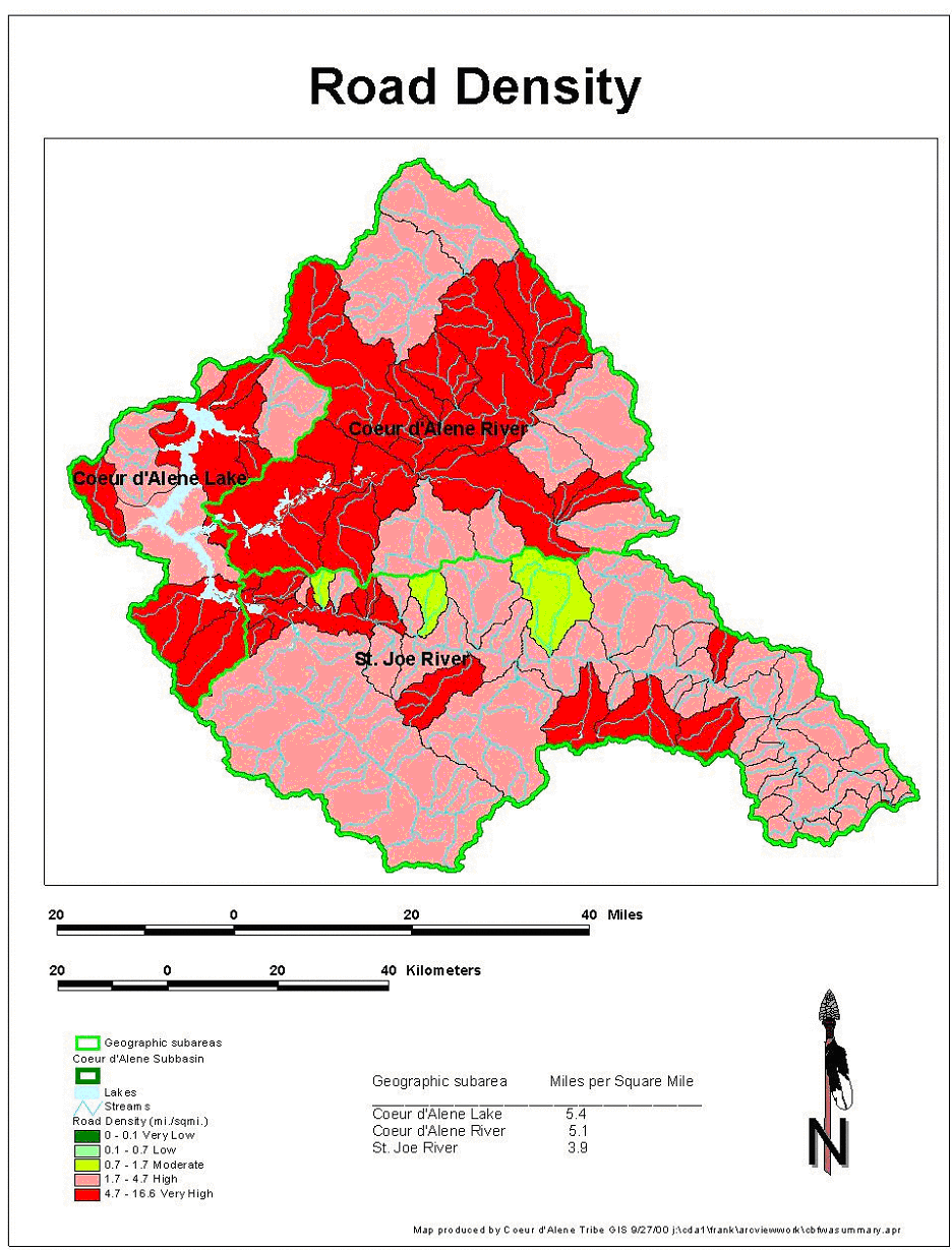