No. 24. Montane Coniferous WetlandsChristopher B. ChappellGeographic Distribution. This habitat occurs in mountains throughout much of Washington and Oregon, except the Basin and Range of southeastern Oregon, the Klamath Mountains of southwestern Oregon, and the Coast Range of Oregon. This includes the Cascade Range, Olympic Mountains, Okanogan Highlands, Blue and Wallowa mountains.
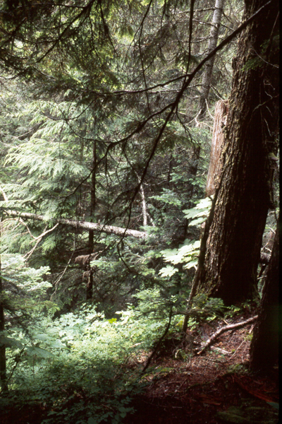
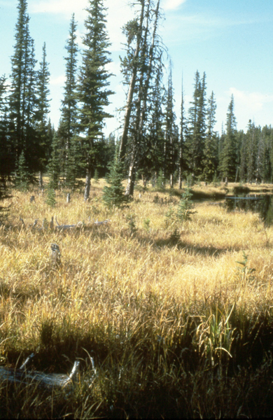
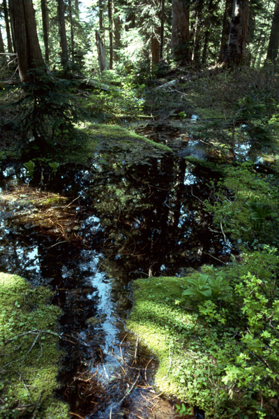
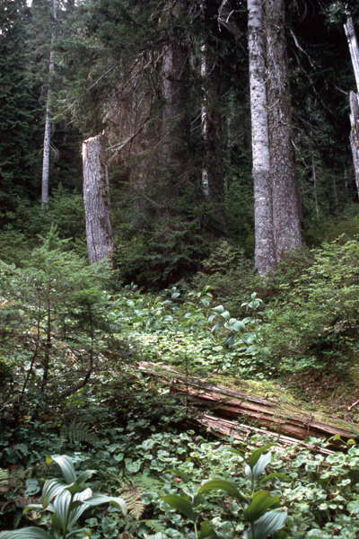
Landscape Setting. This habitat occurs along stream courses or as patches, typically small, within a matrix of Montane Mixed Conifer Forest, or less commonly, Eastside Mixed Conifer Forest or Lodgepole Pine Forest and Woodlands. It also can occur adjacent to other wetland habitats: Eastside Riparian-Wetlands, Westside Riparian-Wetlands, or Herbaceous Wetlands. The primary land uses are forestry and watershed protection. Structure. This is a forest or woodland (>30% tree canopy cover) dominated by evergreen conifer trees. Deciduous broadleaf trees are occasionally co-dominant. The understory is dominated by shrubs (most often deciduous and relatively tall), forbs, or graminoids. The forb layer is usually well developed even where a shrub layer is dominant. Canopy structure includes single-storied canopies and complex multi-layered ones. Typical tree sizes range from small to very large. Large woody debris is often a prominent feature, although it can be lacking on less productive sites.
Dominant or co-dominant shrubs include devil’s-club (Oplopanax horridus), stink currant (Ribes bracteosum), black currant (R. hudsonianum), swamp gooseberry (R. lacustre), salmonberry (Rubus spectabilis), red-osier dogwood (Cornus sericea), Douglas’ spirea (Spirea douglasii), common snowberry (Symphoricarpos albus), mountain alder (Alnus incana), Sitka alder (Alnus viridis ssp. sinuata), Cascade azalea (Rhododendron albiflorum), and glandular Labrador-tea (Ledum glandulosum). The dwarf shrub bog blueberry (Vaccinium uliginosum) is an occasional understory dominant. Shrubs more typical of adjacent uplands are sometimes co-dominant, especially big huckleberry (V. membranaceum), oval-leaf huckleberry (V. ovalifolium), grouseberry (V. scoparium), and fools huckleberry (Menziesia ferruginea). Graminoids that may dominate the understory include bluejoint reedgrass (Calamagrostis canadensis), Holm’s Rocky Mountain sedge (Carex scopulorum), widefruit sedge (C. angustata), and fewflower spikerush (Eleocharis quinquiflora). Some of the most abundant forbs and ferns are ladyfern (Athyrium filix-femina), western oakfern (Gymnocarpium dryopteris), field horsetail (Equisetum arvense), arrowleaf groundsel (Senecio triangularis), two-flowered marshmarigold (Caltha leptosepala ssp. howellii), false bugbane (Trautvetteria carolinensis), skunk-cabbage (Lysichiton americanus), twinflower (Linnaea borealis), western bunchberry (Cornus unalaschkensis), clasping-leaved twisted-stalk (Streptopus amplexifolius), singleleaf foamflower (Tiarella trifoliata var. unifoliata), and five-leaved bramble (Rubus pedatus).
Natural Disturbance Regime. Flooding, debris flow, fire, and wind are the major natural disturbances. Many of these sites are seasonally or temporarily flooded. Floods vary greatly in frequency depending on fluvial position. Floods can deposit new sediments or create new surfaces for primary succession. Debris flows/torrents are major scouring events that reshape stream channels and riparian surfaces, and create opportunities for primary succession and redistribution of woody debris. Fire is more prevalent east of the Cascade Crest. Fires are typically high in severity and can replace entire stands, as these tree species have low fire resistance. Although fires have not been studied specifically in these wetlands, fire frequency is probably low. These wetland areas are less likely to burn than surrounding uplands, and so may sometimes escape extensive burns as old forest refugia 1. Shallow rooting and wet soils are conducive to windthrow, which is a common small-scale disturbance that influences forest patterns. Snow avalanches probably disturb portions of this habitat in the northwestern Cascades and Olympic Mountains. Fungal pathogens and insects also act as important small-scale natural disturbances.
Effects of Management and Anthropogenic Impacts. Roads and clearcut logging practices can increase the frequency of landslides and resultant debris flows/torrents, as well as sediment loads in streams 198, 199, 229. This in turn alters hydrologic patterns and the composition and structure of montane riparian habitats. Logging typically reduces large woody debris and canopy structural complexity. Timber harvest on some sites can cause the water table to rise and subsequently prevent trees from establishing 221. Wind disturbance can be greatly increased by timber harvest in or adjacent to this habitat. Status and Trends. This habitat is naturally limited in its extent and has probably declined little in area over time. Portions of this habitat have been degraded by the effects of logging, either directly on site or through geohydrologic modifications. This type is probably relatively stable in extent and condition, although it may be locally declining in condition because of logging and road building. Five of 32 plant associations representing this habitat listed in the National Vegetation Classification are considered imperiled or critically imperiled 10. [ Top ] [ Literature Citations ] [ Wildlife-Habitat Types - Table 1 ] |