No. 28. Bays and EstuariesMikell O’Mealy and David H. JohnsonGeographic Distribution. This habitat reflects areas with significant mixing
of salt and freshwater, including lower reaches of rivers, intertidal sand and
mud flats, saltwater and brackish marshes, and open-water portions of associated
bays. The habitat is distributed along the marine coast and shoreline of
Washington and Oregon. There are some 21 principal bays and estuaries on the
Oregon coast, and 34 in Washington 5, 95, 178. Willapa Bay and Grays
Harbor (both in Washington) are expansive and have the largest and second
largest intertidal areas of the 2 states. The Columbia River Estuary is the
largest estuary in the Pacific Northwest. This habitat does not include open
water areas of Puget Sound (see Inland Marine Deeper Waters). Similar bay and
estuarine habitats exist on the coasts of California and British Columbia. The greater Puget Sound at times is considered a very large estuary 180; for purposes of this project Puget Sound is comprised of 3 wildlife habitats: Bays and Estuaries, Marine Nearshore, and Inland Marine Deeper Waters. Physical Setting. Climate is moderated by the Pacific Ocean and is usually mild. Mean temperatures at coastal stations generally range from 40 to 70°F (4-21°C) year-round with little north-south variation within Washington and Oregon. Annual rainfall along the coastal zone averages 80-90 inches (203-229 cm) and is concentrated in winter months, producing correspondingly high river runoff to bays and estuaries 173, 176. Elevation is at sea level to a few feet above. Coastal zone topography is characterized by long stretches of sandy beaches broken by steep rocky cliffs, rocky headlands, and the mouths of bays and estuaries. Organics, silt, and sand are the primary substrate components of this habitat and vary in specific composition and distribution with variable physical factors 120.
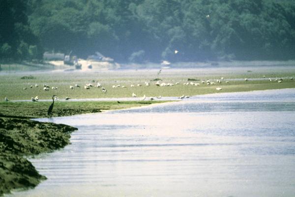
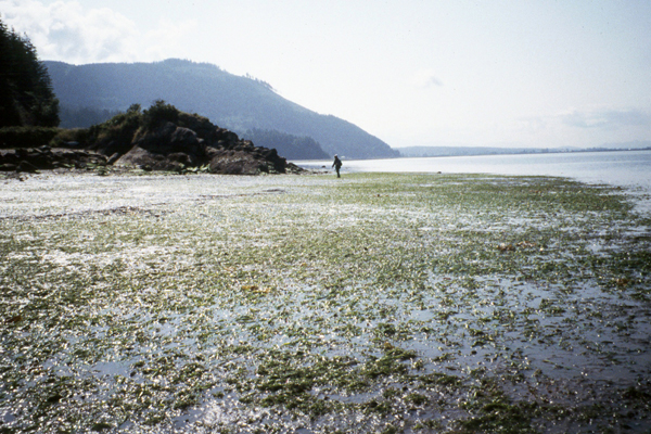
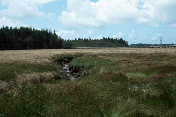
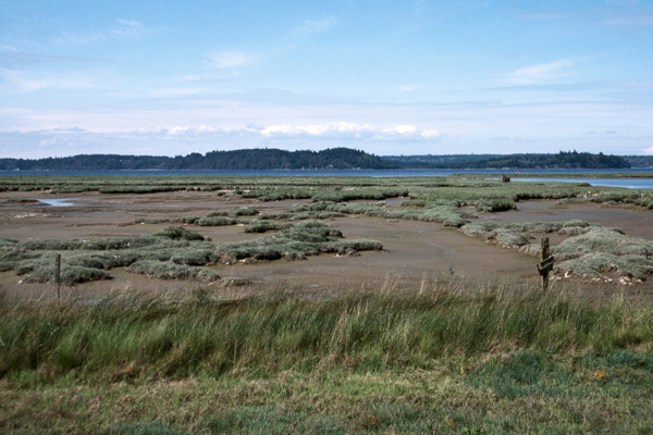
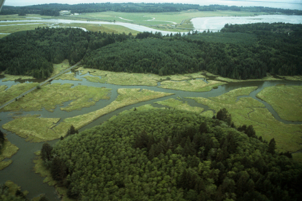
Structure. At the most seaward extent (e.g., river mouths), water depths are shallow (mostly <20 ft [6 m]) except for dredged channels. This habitat is strongly influenced by the daily tides and currents. Depending on location, mean higher high water to mean lower low water ranges from 6.1 to 10.2 ft (1.9 to 3.1 m). Tidal currents in channels of the principal estuaries typically range from 1 to 5 knots (0.5 to 2.6 m/sec) 176. Diverse habitats result from riverine discharges and tidal fluxes, salinity, mixing, sedimentation, discharge, and insolation. Unconsolidated or consolidated tideflats are composed of rocks, gravel, sand, silt and clay as well as abundant organic material 68, 204. Inundated by daily tidal flows, tideflats may support eelgrass, various algal species, and invertebrate communities 5. Eelgrass meadows create protected environments and structured habitats for various wildlife species 173. Salt marshes form at the upper tidal boundary above tideflats 120. Salt marshes are usually open to closed graminoid or forb communities. Highly branched estuarine channels drain across salt marshes and tideflats, creating a diverse mix of structures 192. At the most inland extent of this habitat, transitional marsh forms between salt marshes and bordering upland vegetation dominated by grass or woody vegetation 6.
Composition. Eelgrass meadows stabilize submerged tideflats and are co-dominated by surfgrass and eelgrass species. Three diagnostic surfgrass species (Phyllospadix scouleri, P. torreyi, and P. serrulatus) occur on rocky substrates in exposed waters, whereas 2 species of eelgrasses (Zostera marina, Z. japonica) are characteristic of mud or mixed mud-sand substrates in areas sheltered from turbulent waters 68, 173. Highly productive macroalgae that dominate estuarine channels include various blue-green algae, green algae (Enteromorpha spp.) and rockweed (Fucus spp.) 192. Tideflats bordering salt marshes often are co-dominated by pickleweed (Salicornia virginica), arrowgrass (Triglochin maritima) and three-square rush (Scirpus americanus) 5. The transition to higher areas of the low-marsh zone is indicated by the dominance of jaumea (Jaumea carnosa), saltgrass (Distichlis spicata), and Lyngby’s sedge (Carex lyngbyei) 68. Major components of mid- and high salt marsh areas are alkaligrass (Puccinellia pumila) and Canadian sand spurry (Spergularia canadensis) 120. Salt rush (Juncus lesueurii), tufted hairgrass (Deschampsia caespitosa), Pacific silverweed (Argentina egedii) and spreading bentgrass (Agrostis stolonifera) are salt-tolerant upland species diagnostic of high salt marshes that experience freshwater runoff or riverine discharge 6.
Succession and Stand Dynamics. General successional stages reflect unconsolidated barren tideflats to stabilized high salt marshes and salt meadows. Unvegetated tideflats are colonized by pioneer plants, commonly eelgrass, that are tolerant of extended tidal inundation and vary depending on sediment type 173. Initial colonization causes sediment accretion and gradual rise in land elevation, changes that shift environmental conditions and permit other plants to establish. Arrowgrass, pickleweed, sand spurry, and spike rush can invade the emerging marsh, further increasing and stabilizing substrates. Saltgrass and sedge establish on higher areas of the marsh. When initial colonizers die back, tufted hairgrass and salt rush may establish 5. Various exotic species have become naturalized in Oregon and Washington, including spreading bentgrass (Agrostis stolonifera) and sand spurry (Spergularia marina) introduced from Europe, brass buttons (Cotula coronopifolia) introduced from South Africa, and marsh cordgrass (Spartina alterniflora) introduced from the Atlantic Coast of North America 6, 120. These successional stages can be disrupted by riverine or tidal scouring and succession can be reinitiated at any point.
Status and Trends. Significant quantitative and qualitative alterations of this habitat have occurred with Euro-American settlement. Although natural erosion and accretion processes continue, most habitat modification can be attributed to anthropogenic impacts 192. Because of original diking for crop production and flood control, almost no areas of natural high marsh remain in Oregon 120. These dikes, and other more recent barriers, prevent natural recovery and re-establishment of this habitat. Remaining examples of the bay and estuarine habitat exist in various conditions, from the more natural areas, areas undergoing active restoration, to the more prevalent polluted, degraded, or overused areas throughout Oregon and Washington. With increasing population pressures in coastal areas and the corresponding threats of habitat use and conversion, future trends will likely be continued degradation and reduction of remaining bay and estuarine areas. [ Top ] [ Literature Citations ] [ Wildlife-Habitat Types - Table 1 ] |