| Proposal title | Implement Floodplain Operational Loss Assessment, Protection, Mitigation and Rehabilitation on the Lower Kootenai River Watershed Ecosystem |
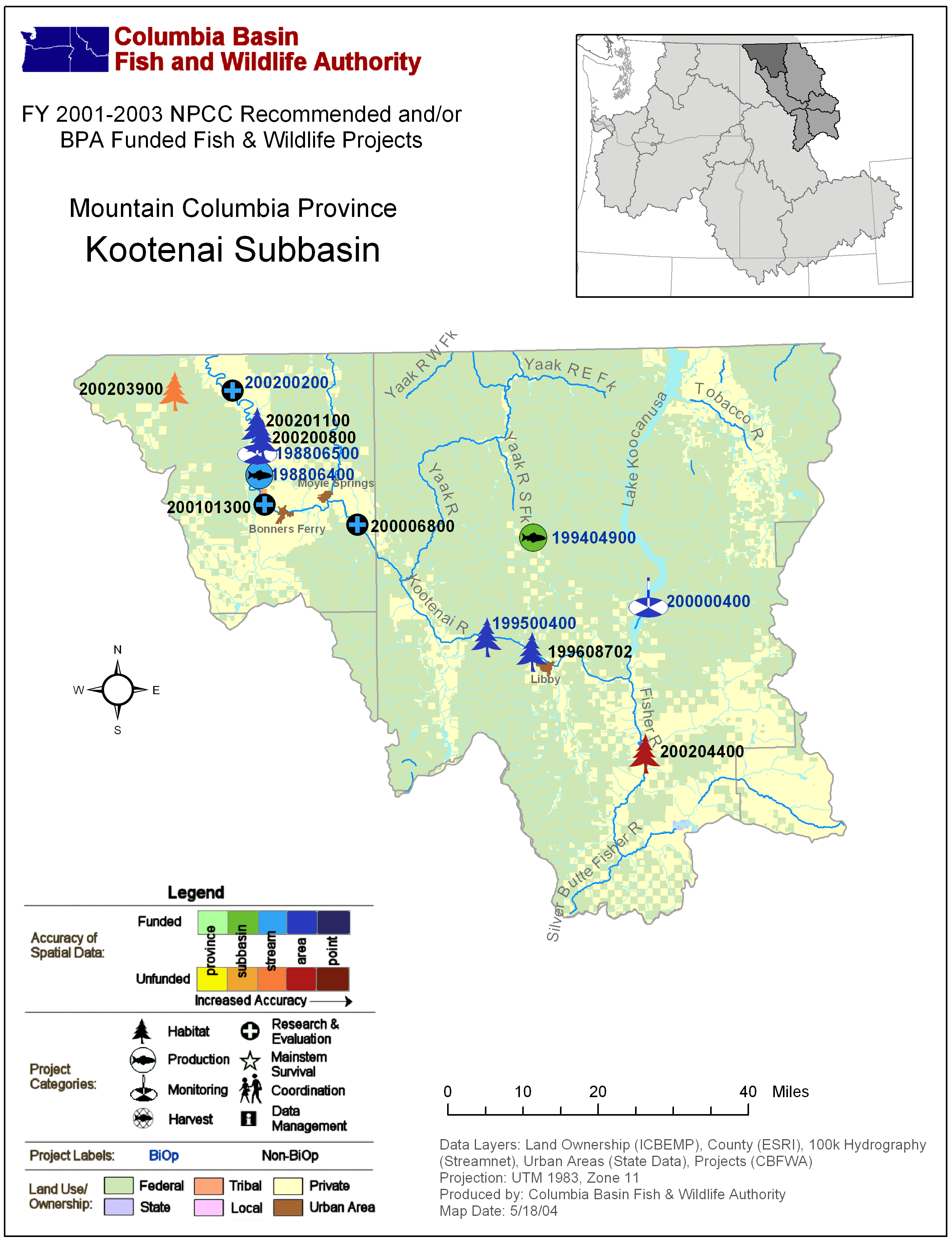
| Proposal ID | 200201100 |
| Organization | Kootenai Tribe of Idaho (KTOI) |
| Proposal contact person or principal investigator |
| Name | Scott Soults |
| Mailing address | P.O. Box 1269 Bonners Ferry, ID 83805 |
| Phone / email | 2082673620 / soults@kootenai.org |
| Manager authorizing this project | Scott Soults |
| Review cycle | Mountain Columbia |
| Province / Subbasin | Mountain Columbia / Kootenai |
| Short description | Pilot project to assess operational losses with long-term mitigation, protection, enhancement, rehabilitation in floodplain ecosystems on the Lower Kootenai River Watershed. |
| Target species | Black bear, moose, beaver, mink, river otter, muskrat, white-tailed deer, yellow warbler, elk |
| Objective | Task | Duration in FYs | Estimated 2002 cost | Subcontractor |
|---|
| 1) Review, analyze and select research projects that will best assess operational losses in the Lower Kootenai River Watershed and are regionally applicable. |
(a) Review and consolidate literature on past operational loss assessment designs, activities, and related biological information. |
2002 |
$2,500 |
|
|
(b) Develop a list of qualified personnel, solicit involvement and implement a Research Design Review Team (RDRT) to review and select research projects that will best assess operational losses in the Lower Kootenai River Watershed and are regionally appl |
2002 |
$3,500 |
|
|
(c) RDRT develop criteria for ranking and selection of operational loss assessments projects. |
2002 |
$4,500 |
Yes |
|
(d) RDRT develop and write Request For Proposals (RFP) soliciting for operational loss assessment projects. |
2002 |
$2,500 |
Yes |
|
(e) RDRT develop a vendor list and submit RFP to a broad base of research professionals. |
2002 |
$650 |
Yes |
|
(f) RDRT review, rank and select the “top 10” research design proposals for operational loss studies. |
2002 |
$2,500 |
Yes |
|
(g) RDRT organize and implement an open review forum (Operational Loss Symposium) for presentations, RDRT final review and selection of research projects that best assess operational losses in the Lower Kootenai River Watershed |
2002 |
$6,000 |
Yes |
|
(h) Implement a minimum of two research projects that best assess operational losses in the Lower Kootenai River Watershed and are regionally applicable. |
2003 |
$0 |
Yes |
| 2)Assess historic (early 1900’s) and current condition and status of floodplain vegetation types, slough, pocket water and associated watercourses within the Lower Kootenai River Watershed by 2003. |
(a) Review and consolidate literature on historic vegetation communities within the lower Kootenai River Watershed floodplain. |
2002 |
$5,000 |
|
|
(b) Conduct interviews of long time residents, Tribal members and elders to document local knowledge of historic Lower Kootenai Watershed stream courses and plant communities. |
2002 |
$10,000 |
|
|
(c) Develop an inventory of historical aerial photographs, site-specific photos for the Lower Kootenai Watershed, natural analogue sites and surrounding areas. |
2002 |
$1,000 |
|
|
(d) Consolidate original streambed and floodplain survey data existing for the Lower Kootenai Watershed (i.e., pre-channelization and land leveling). |
2002 |
$18,000 |
|
|
(e) Create a Geographical Information System (GIS) layer by digitizing tributaries, sloughs, pocket water and floodplain topography before channelization and land leveling (pre 1920’s surveys and 1928 GLO maps). |
2002 |
$18,500 |
Yes |
| 3) Produce hydrologic models for the floodplain and each natural analogue stream course by 2003. |
(a) Conduct assessments of tributary, slough and oxbow and river channel functions. |
2002 |
$28,900 |
Yes |
|
(b) Identify a reference reach with two full meanders for each tributary/slough/oxbow/watercourse to be restored (or similar fluvial geomorphology model may be utilized to assess other factor such as rearing habitat, etc.). |
2002 |
$20,000 |
|
|
(c) Develop hydrologic models based on the surveyed cross-sections of reference reaches (i.e., fluvial geomorphology, tributary and slough interactions). |
2002 |
$0 |
Yes |
|
(d) Develop a GIS layer of historical native vegetation communities and distributions within the Lower Kootenai Watershed utilizing EDT data and soils data. |
2003 |
$0 |
Yes |
|
(e) EPA Work - Assessment of vegetation and stratification of environments on the Kootenai River dike system. |
2002 |
$0 |
|
|
(f) Assess and compare impacts of regulated and unregulated water levels on semiaquatic furbearers. |
2002-2003 |
$32,856 |
|
|
(g) Assess the braided and meandering Lower Kootenai River reaches from a riparian vegetation life stage analysis. |
2002 |
$20,000 |
|
| 4) Develop a framework for regional floodplain operational loss assessments by 2004, with the use of Lower Kootenai River floodplain operational assessment, EDT, and normative analogue comparisons during 2003. |
(a) Detail floodplain potential, priority restoration and protection areas in the Lower Kootenai Watershed using historical and existing vegetation coverage, EDT, analogue comparisons and current land ownership. |
2002 |
$10,000 |
Yes |
|
(b) Detail a strategy for dike soil stabilization and riparian vegetation propagation potentials, priority restoration and protection areas along the Lower Kootenai River Watershed dike system. |
2003 |
$0 |
Yes |
|
(c) Initiate analysis and peer review of operational loss assessment estimation techniques for regional review. |
2003-2004 |
$0 |
|
|
(d) Produce publication of historical vegetation patterns and associations in the Lower Kootenai River Watershed. |
2004 |
$0 |
|
| 5)Plan and establish a trust fund or other funding strategy for securing management rights, and operations and maintenance to mitigate priority floodplain habitat areas by 2005. |
(a) Establish a trust fund to secure management rights. |
2005 |
$0 |
|
| Objective | Task | Duration in FYs | Estimated 2002 cost | Subcontractor |
|---|
| 1) By year10, rehabilitate 15 percent or more of the riparian habitat lost in the Kootenai subbasin with the no new net losses of riparian habitat. |
(a) Design management plan, HEP survey, Rehabilitate with shrubs, grass and other vegetation associated with high priority habitat. |
ongoing after 2005 |
$0 |
|
| 2) By year 10, rehabilitate 15 percent or more of the wetland habitat lost in the Kootenai subbasin with no new net losses of wetland habitat. |
(a) Design management plan, HEP survey, Rehabilitate with shrubs, grass and other vegetation associated with high priority habitat. |
ongoing after 2005 |
$0 |
|
| 3) By year 10, rehabilitate 15 percent or more of grassland habitats lost in the Kootenai subbasin with no new net losses of grassland habitats. |
(a) Design management plan, HEP survey, Rehabilitate with shrubs, grass and other vegetation associated with high priority habitat. |
ongoing after 2005 |
$0 |
|
| 4) By year 10, rehabilitate 20 percent or more of the aspen forest habitat lost in the Kootenai subbasin with no new net losses of aspen forest habitats. |
(a) Design management plan, HEP survey, Rehabilitate with shrubs, grass and other vegetation associated with high priority habitat. |
ongoing after 2005 |
$0 |
|
| 5) Promote potential for providing dual benefits to both fish and wildlife resources. |
(a) Design management plan, HEP survey, Rehabilitate with shrubs, grass and other vegetation associated with high priority habitat. |
ongoing after 2005 |
$0 |
|
| Objective | Task | Duration in FYs | Estimated 2002 cost | Subcontractor |
|---|
| 1) Assist in the coordination and development of a Lower Kootenai River Watershed Council (Citizen/Technical Committee) |
(a) assist facilitate technical group, present projects, research and attend meetings |
ongoing |
$2,728 |
|
| 2) Identify and evaluate effectiveness of existing local and regional conservation programs and funding mechanisms for floodplain, wetland and riparian protection, rehabilitation and enhancement activities by 2003. |
(a) Investigate local and regional Federal, State, County, and City or private organizations for grant and cost share program information |
2003 |
$0 |
|
| 3) Detail a strategy for incorporation of floodplain restoration, rehabilitation in LKRWC watershed strategy by 2004. |
(a) Present information, slideshows, data, materials to propose floodplain restoration and positive effects, education and information. |
2004 |
$0 |
|
| 4) Promote long term benefits to fish and wildlife populations. |
(a) Develop outreach programs, tours, slideshows, education and information exchanges with schools, etc. |
2002 |
$450 |
|
| 5) Coordinate all project planning, implementation, monitoring and evaluation efforts and associated results with other regional and provincial fish and wildlife managers, BPA, and the NWPPC. |
(a) Information exchange, attend BPA/NWPPC/CBFWA meetings and workshops, present data at professional meetings and workshops, etc. |
ongoing |
$3,280 |
|
| Objective | Task | Duration in FYs | Estimated 2002 cost | Subcontractor |
|---|
| 1) Develop a monitoring and evaluation protocol for determining effectiveness of implementation activities (i.e., CBFWA –wildlife manager document, etc.). |
(a) Utilize CBFWA plans and incorporate site-specific strategies for water control structures, field computer tracking program (excel), HEP |
ongoing |
$0 |
|
| 2) Monitor trends in parameters for determining effectiveness of implementation activities. |
(a) baseline surveys, HEP revisits, and field computer tracking program (excel) |
ongoing |
$0 |
|
| 3) Conduct evaluations of survival and growth of restoration and enhancement plantings. |
(a) Field computer tracking program (excel), Survey small mammal damage, weed control survey |
ongoing |
$0 |
|
| 4) Conduct annual noxious weed monitoring. |
(a) Coordinate with extension service on surveys, field computer tracking program (excel) |
ongoing |
$0 |
|
| 5) Monitor the overall effectiveness of the restoration projects. |
(a) Photo points, field computer tracking program (excel and SAS) |
ongoing |
$0 |
|
| 6) Adapt management plans, strategies and objectives to sustain and promote benefits to wildlife populations and habitats. |
(a) Re-tool field computer tracking program (excel and SAS), breeding bird surveys, transects for presence/absence |
ongoing |
$0 |
|
This information was not provided on the original proposals, but was generated during the review process.
The proposal does have three significant deficiencies. First, the flood-pulse concept from the river-ecology literature is not mentioned. Even more important, a though the proposal recognizes that "the watershed has little likelihood of functioning the same way it did 200 years ago", there is no mention of what alternative land and water management practices will be considered. For instance, are there alternate operating policies for Libby Dam that might help to restore functioning of the flood plain? If there is no chance of restoring ecological function, what is the purpose of a five-year, $5M project? Furthermore, the proposal includes information about only one of the "key personnel" - for this kind of money, there must be more people working on the project? In any case, there is no evidence that a qualified hydrologist will be involved in the project. Given the magnitude of the funding requested, ISRP requests a revised proposal that addresses the above three deficiencies, and in addition provides a concise list of deliverables, an internal review process, and funding milestones. Vitae for key project personnel are essential.